
Memorials & monuments · South East England
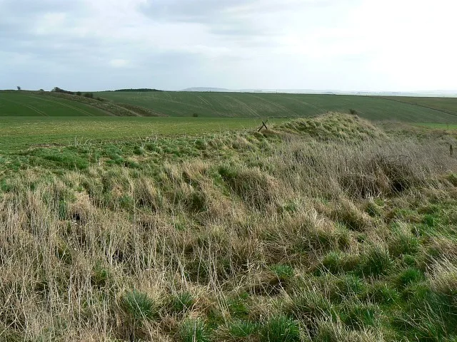
Cross Dyke
In or near Upavon.
Cross Dyke — a memorial in england-south-east, United Kingdom.

Brian Robert Marshall — CC BY-SA 2.0 via Wikimedia Commons licence

Plan your visit
- Typical visit
- 15 min–45 min
- Nearest railway station
- Pewsey · 9.2 km
- Free entry
- Dog-friendly
Getting there & planning your visit
To visit Cross Dyke, the nearest railway station is Pewsey, located 9.2 km away. The postcode for navigation is SN9 6EE, and entry to the memorial is free.
About
Cross Dyke is a memorial located in england-south-east, United Kingdom. Sourced from OpenStreetMap (ODbL licence); see local listings for visitor information, opening hours and admission details.
Photo gallery
Protected designations
- Site of Special Scientific Interest: River Avon System SSSI
- Site of Special Scientific Interest: Salisbury Plain SSSI
- Area of Outstanding Natural Beauty: North Wessex Downs
Designations sourced from Natural England open data under OGL v3.
From the Wikipedia article
A cross dyke or cross-dyke (also referred to as a cross-ridge dyke, covered way, linear ditch, linear earthwork or spur dyke) is a linear earthwork believed to be a prehistoric land boundary that usually measures between 0.2 and 1 kilometre (0.12 and 0.62 mi) in length. A typical cross dyke consists of one or more ditches running in parallel with one or more raised banks. Univallate cross dykes typically have a flat-bottomed ditch while the ditches of multivallate cross dykes possess a V-shaped cross-section. A defining characteristic of a cross dyke is that it cuts across the width of an upland ridge or the neck of an upland spur. Cross dykes generally occur at altitudes over 150 metres (490 ft) above mean sea level.
Excerpt from Wikipedia under CC BY-SA 4.0. See the source article linked in Sources below.
- Coordinates
- 51.2720, -1.8417
- District
- Wiltshire
- Parish
- Upavon
- Postcode
- SN9 6EE
- Parliamentary constituency
- East Wiltshire
- Nearest railway station
- Pewsey — 9.2 km
Sources
- osm: node/3808366601 (ODbL)
- wikipedia: Cross dyke (CC BY-SA 4.0)
Other places nearby
Casterley Camp
Hill forts · 1.1 km
Slay Barrow
Burial mounds & barrows · 2.8 km

Three Baden Monuments In Churchyard, 14 Metres South Of Tower, Church Of All Saints
Memorials & monuments · 3.1 km

Church of All Saints And St Margaret
Historic churches · 3.1 km

Enford
Villages · 3.1 km

Cleave Hill
Mountains & hills · 3.2 km

Upavon Cemetery War Memorial
Memorials & monuments · 3.3 km

Upavon
Towns & cities · 3.4 km

Group Of Fowle Monuments In Churchyard, 8 Metres South Of Chancel, Church Of St Peter
Memorials & monuments · 3.6 km

Charlton Manor
Caravan parks · 3.7 km

Longstreet
Villages · 3.8 km

Rushall Manor Park Bridge
Historic bridges · 3.8 km
Nearby
📷 5Hill forts · South East England
Casterley Camp
Casterley Camp — site of an Iron Age univallate hillfort located in Wiltshire, England, UK.
Burial mounds & barrows · South West England
Slay Barrow
Slay Barrow — a burial mound in england-south-east, United Kingdom.
📷 5Memorials & monuments · South East England
Three Baden Monuments In Churchyard, 14 Metres South Of Tower, Church Of All Saints
Three Baden Monuments In Churchyard, 14 Metres South Of Tower, Church Of All Saints — Grade II listed building-listed memorial in england-south-east, United Kingdom.
📷 5Historic churches · South East England
Church of All Saints And St Margaret
Church of All Saints And St Margaret — Grade I listed church in Enford, Wiltshire, England, UK.
📷 5📷 5Mountains & hills · South East England
Cleave Hill
Cleave Hill — mountain in england south east. Elevation: 170 m.
Where to eat & stay near Cross Dyke
Places to stay
📷 5Caravan parks · South East England
Charlton Manor
Charlton Manor — a caravan park in england south east.
 📷 5
📷 5Campsites · South East England
The Woodbridge Camp SIte
The Woodbridge Camp SIte — a campsite in england south east.
 📷 5
📷 5B&Bs · South West England
Puckshipton House
Puckshipton House — a bed-and-breakfast in england south east.
 📷 5
📷 5Campsites · South West England
Stonehenge Touring Park
Stonehenge Touring Park — a campsite in england south east.
 📷 5📷 5
Places to eat & drink
 📷 5
📷 5 📷 5
📷 5Historic pubs · South West England
The Greyhound Tavern
The Greyhound Tavern in England South West, United Kingdom.
 📷 5
📷 5 📷 7
📷 7Historic pubs · South West England
Black Swan Hotel
Black Swan Hotel in England South West, United Kingdom.
 📷 5
📷 5Historic pubs · South West England
Malet Arms
Malet Arms in England South West, United Kingdom.
 📷 7
📷 7Cafés · South East England
St Peter's and St Paul's
St Peter's and St Paul's — a café in england south east.
More memorials in this region
 📷 5
📷 5Memorials & monuments · South East England
Air Forces Memorial
Air Forces Memorial is a memorial in the United Kingdom.
 📷 5
📷 5Memorials & monuments · South East England
All Saints Church
All Saints Church is a memorial in the United Kingdom.
 📷 5
📷 5Memorials & monuments · South East England
Bevans War Memorial
Bevans War Memorial is a memorial in the United Kingdom.
.jpg?width=1200) 📷 5
📷 5Memorials & monuments · South East England
Cumberland Obelisk
Cumberland Obelisk is a memorial in the United Kingdom.
Frequently asked questions
- Where is Cross Dyke?
- Cross Dyke is in South-East England, United Kingdom (postcode SN9 6EE), in the parish of Upavon.
- What is Cross Dyke?
- Cross Dyke — a memorial in england-south-east, United Kingdom.
- How do I get to Cross Dyke?
- The nearest railway station is Pewsey, about 9.2 km away. Drivers can use postcode SN9 6EE.
- Is Cross Dyke a protected site?
- Yes — Cross Dyke is part of the River Avon System SSSI Site of Special Scientific Interest and the Salisbury Plain SSSI Site of Special Scientific Interest.
- Is Cross Dyke free to visit?
- Yes, Cross Dyke is free to enter.
- How do I get to Cross Dyke?
- Drivers can navigate to postcode SN9 6EE. It sits within the East Wiltshire parliamentary constituency.