Mountains & hills · Scottish Lowlands
Craigencolon
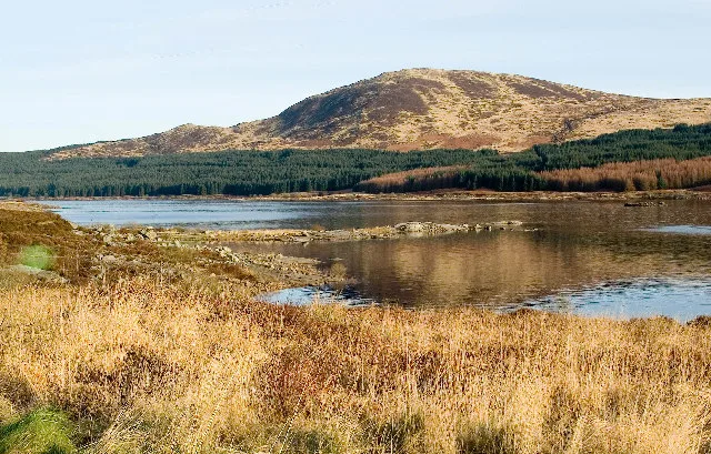
Craigencolon — mountain in scotland lowlands. Elevation: 346 m.

Brian Barclay — CC BY-SA 2.0 via Wikimedia Commons licence
Plan your visit
- Typical visit
- 3 h–8 h
- Best time of year
- Late spring – early autumn (May–Oct)
About
Craigencolon is a mountain located in scotland lowlands. Elevation: 346 m. A named British peak recorded in OpenStreetMap. Peaks are typically named on Ordnance Survey 1:50k mapping.
Photo gallery
Place summary
Craigencolon is a mountain located in the Scottish Lowlands. It is part of the varied landscape characteristic of the region, offering opportunities for walking and exploration. The area is known for its natural beauty and outdoor activities, attracting those interested in hiking and enjoying the countryside. Visitors can expect a tranquil environment, ideal for both casual walkers and more experienced hikers.
AI-generated from the structured facts on this page (operator, designation, listing, era). Not a substitute for visiting.
- Coordinates
- 55.2422, -4.3546
Sources
- osm: n6311276029 (ODbL)
Other places nearby
Loading nearby places…
Nearby
 📷 5
📷 5Mountains & hills · Scottish Lowlands
Eldrick
Eldrick — mountain in scotland lowlands. Elevation: 396 m.
 📷 5
📷 5Vineyards · Scottish Lowlands
Donald's Isle, Loch Doon, settlement 750m SSW of Lamdoughty Farm
Donald's Isle, Loch Doon, settlement 750m SSW of Lamdoughty Farm — a UK vineyard in scotland lowlands, producing English or Welsh wine from cool-climate grape varieties.
📷 5Mountains & hills · Scottish Lowlands
Cullendoch (Cuilleannach)
Cullendoch (Cuilleannach) — mountain in scotland lowlands. Elevation: 343 m.
📷 5Mountains & hills · Scottish Lowlands
Cullendoch Hill
Cullendoch Hill — a hill or mountain in scotland lowlands.
 📷 3
📷 3Natural landmarks · Scottish Lowlands
Loch Doon
Loch Doon — lake in East Ayrshire, Scotland, UK, outflows to the River Doon.
 📷 5
📷 5Mountains & hills · Scottish Lowlands
Little Craig
Little Craig — mountain in scotland lowlands. Elevation: 338 m.
Where to eat & stay near Craigencolon
Places to stay
 📷 5
📷 5Caravan parks · Scottish Lowlands
Loch Doon Caravan Park
Loch Doon Caravan Park — a caravan park in scotland lowlands.
 📷 5
📷 5Campsites · Scottish Lowlands
Glentrool Camping & Caravan Site
Glentrool Camping & Caravan Site — a campsite in scotland lowlands.
 📷 5
📷 5Campsites · Scottish Lowlands
Otter Pool "Stay the night"
Otter Pool "Stay the night" — a campsite in scotland lowlands.
Places to eat & drink
 📷 5
📷 5Historic pubs · Scottish Lowlands
Doon Tavern, High Street, Dalmellington
Doon Tavern, High Street, Dalmellington in Scotland Lowlands, United Kingdom.
 📷 5
📷 5Historic pubs · Scottish Lowlands
The White House and Adjoining Joiner's Shop, Kirkmichael Arms, Straiton Road, Kirkmichael
The White House and Adjoining Joiner's Shop, Kirkmichael Arms, Straiton Road, Kirkmichael in Scotland Lowlands, United Kingdom.
 📷 5
📷 5Historic pubs · Scottish Lowlands
The Sun Inn, 23 The Square, Cumnock
The Sun Inn, 23 The Square, Cumnock in Scotland Lowlands, United Kingdom.
 📷 5
📷 5Historic pubs · Scottish Lowlands
Commercial Inn, 1-3 Mill Street, Ochiltree
Commercial Inn, 1-3 Mill Street, Ochiltree in Scotland Lowlands, United Kingdom.
More mountains in this region
 📷 3
📷 3Mountains & hills · Scottish Lowlands
Andrewhinney Hill
Andrewhinney Hill — Named summit at 677 m.
 📷 3
📷 3Mountains & hills · Scottish Lowlands
Arbory Hill
Arbory Hill — Named summit at 429 m.
 📷 3
📷 3Mountains & hills · Scottish Lowlands
Auchenton Hill ( East Mount Lowther)
Auchenton Hill ( East Mount Lowther) — Named summit at 631 m.
 📷 3
📷 3Mountains & hills · Scottish Lowlands
Bakestall
Bakestall — Named summit at 673.5 m.
Frequently asked questions
- Where is Craigencolon?
- Craigencolon is in the Scottish Lowlands, United Kingdom.
- What is Craigencolon?
- Craigencolon — mountain in scotland lowlands. Elevation: 346 m.
- How do I get to Craigencolon?
- Its coordinates are 55.2422°, -4.3546°.