
Natural landmarks · Mid Wales
Craig-y-llyn
In or near Abergynolwyn.
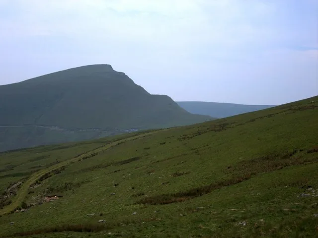
Craig-y-llyn — mountain (622m) in Gwynedd, Wales.

Wikimedia Commons contributors — see linked file page for photographer and licence licence

Plan your visit
- Typical visit
- 1 h–2 h
- Nearest railway station
- Morfa Mawddach · 4.3 km
- Free entry
- Dog-friendly
Getting there & planning your visit
To visit Craig-y-llyn, the nearest railway station is Morfa Mawddach, located 4.3 km away. Entry to the site is free.
About
Craig-y-llyn is a named natural landmark in the United Kingdom. It covers approximately 115 km². Heritage designation: Site of Special Scientific Interest. Part of Cadair Idris. Wikidata describes it as: "mountain (622m) in Gwynedd, Wales". Coordinates: 52.6891°, -3.9761°.
Photo gallery
From the Wikipedia article
Craig-y-llyn is a subsidiary summit of Cadair Idris in the Snowdonia National Park, in Gwynedd, northwest Wales. It lies at the western end of the long Cadair Idris ridge. Its north-facing cwm houses the small glacial lake, Llyn Cyri. The southern flanks have gentle slopes, while the northern are very steep and contain broken crags. The summit is grassy and marked by a few stones. It is often climbed in combination with Tyrrau Mawr.
Excerpt from Wikipedia under CC BY-SA 4.0. See the source article linked in Sources below.
- Coordinates
- 52.6891, -3.9761
- Address
- Gwynedd, Wales
- Nearest railway station
- Morfa Mawddach — 4.3 km
Sources
- wikidata: Q5180664 (CC0)
- wikipedia: Craig-y-llyn (CC BY-SA 4.0)
- commons: Craig y Llyn - geograph.org.uk - 464735.jpg (CC BY-SA 4.0)
Featured in this guide
Other places nearby
Craig-y-llyn
Mountains & hills · 0.0 km

Twll yr Ogof
Mountains & hills · 0.8 km

Mynydd Pennant
Mountains & hills · 1.5 km

Bryn y Gregennen
Mountains & hills · 1.9 km
Tyrrau Mawr
Mountains & hills · 1.9 km
Tyrrau Mawr
Natural landmarks · 2.0 km

Craig-las
Mountains & hills · 2.0 km

Braich Ddu
Mountains & hills · 2.0 km

Pen Llynnau Cregennen
Mountains & hills · 2.0 km

Arthog Stones
Archaeological sites · 2.3 km

Carnedd Lwyd
Mountains & hills · 2.3 km

Cregennan lakes
Lakes · 2.4 km
Nearby
📷 3📷 5📷 5Mountains & hills · Mid Wales
Mynydd Pennant
Mynydd Pennant — mountain in wales mid. Elevation: 467 m.
📷 5Mountains & hills · Mid Wales
Bryn y Gregennen
Bryn y Gregennen — mountain in wales north. Elevation: 280 m.
📷 3📷 3Where to eat & stay near Craig-y-llyn
Places to stay
 📷 5
📷 5 📷 5📷 5📷 5
Hostels · Mid Wales
Arthog Outdoor Education Centre
Arthog Outdoor Education Centre — a hostel in wales north.
 📷 5
📷 5Campsites · Mid Wales
Hafod Dywyll farm campsite
Hafod Dywyll farm campsite — a campsite in wales north.
 📷 5
📷 5Places to eat & drink
 📷 7
📷 7 📷 7
📷 7 📷 7
📷 7 📷 7
📷 7 📷 5
📷 5Restaurants · Mid Wales
The White Lion Hotel
The White Lion Hotel — a restaurant in wales mid.
 📷 6
📷 6More natural landmarks in this region
 📷 3
📷 3 📷 3
📷 3 📷 3
📷 3Natural landmarks · Mid Wales
Llyn Gwernan
Llyn Gwernan is a natural landmark in the United Kingdom.
 📷 3
📷 3Frequently asked questions
- Where is Craig-y-llyn?
- Craig-y-llyn is in Mid Wales, United Kingdom.
- What is Craig-y-llyn?
- Craig-y-llyn — mountain (622m) in Gwynedd, Wales.
- How do I get to Craig-y-llyn?
- The nearest railway station is Morfa Mawddach, about 4.3 km away. Its coordinates are 52.6891°, -3.9761°.
- Is Craig-y-llyn a listed building?
- Craig-y-llyn is officially recognised as Site of Special Scientific Interest listed.
- Is Craig-y-llyn free to visit?
- Yes, Craig-y-llyn is free to enter.
- How do I get to Craig-y-llyn?
- The nearest railway station is Morfa Mawddach, about 4.3 km away.