
Mountains & hills · South Wales
Coity Mountain
Also known as: Mynydd Coety
In or near Argoed.
Coity Mountain — Named summit at 578 m.

Wikimedia Commons contributors — see linked file page for photographer and licence licence

Plan your visit
- Typical visit
- 3 h–8 h
- Best time of year
- Late spring – early autumn (May–Oct)
- Nearest railway station
- Big Pit halt · 1.2 km
- Free entry
- Dog-friendly
Getting there & planning your visit
Coity Mountain is located in South Wales, with the nearest railway station being Big Pit halt, which is 1.2 km away. Entry to the mountain is free. The postcode for navigation is NP4 9XP.
About
Coity Mountain is a named summit in the United Kingdom. Also known as: Mynydd Coety. Wikidata describes it as: "Named summit at 578 m.". Coordinates: 51.7653°, -3.1149°.
Photo gallery
Protected designations
- Site of Special Scientific Interest: River Wye SSSI
Designations sourced from Natural England open data under OGL v3.
From the Wikipedia article
Coity Mountain (also spelled Coety Mountain, Welsh: Mynydd Coety) is a flat-topped mountain in the South Wales Valleys, between Blaenavon and Abertillery. The highest points of both Torfaen and Blaenau Gwent unitary authorities are at the summit of Coity Mountain. The summit is also known as Twyn Ffynhonnau Goerion. Some 2 km (1 mi) to the southeast lies a major subsidiary top of the hill, Mynydd Varteg Fawr (549m) at the southeastern end of whose broad ridge is a trig point at 544m. A few hundred metres to the southeast of this summit is a memorial known as the Dog Stone which commemorates Carlo the Red Setter, a dog shot accidentally by his master while hunting on the 12 August 1864. Co-ordinates for the Dog Stone 51.45'15.58N 3.05'08.81W. Other notable tops include those of Mulfran (524m) (Welsh for cormorant, pronounced 'mill-vran') which overlooks the town of Brynmawr and Mynydd James immediately east of the town of Blaina. Much of the mountain, including the summit is included in the Blaenavon Industrial Landscape World Heritage Site, and a labyrinth of coal mines, including Big Pit National Coal Museum lies under the mountain.
Excerpt from Wikipedia under CC BY-SA 4.0. See the source article linked in Sources below.
Background
Visiting
A number of public rights of way cross the mountain though none traverse the summit. There are in addition a number of vehicular tracks and smaller paths which run both around its flanks and along its broad main ridge. Most of the mountain is access land under the Countryside and Rights of Way Act 2000 and can be freely traversed on foot.
Sourced from Wikipedia under CC BY-SA 4.0.
- Coordinates
- 51.7653, -3.1149
- District
- Torfaen
- Parish
- Blaenavon
- Postcode
- NP4 9XP
- Parliamentary constituency
- Torfaen
- Nearest railway station
- Big Pit halt — 1.2 km
Sources
- osm: n3342973429 (ODbL)
- wikipedia: Coity Mountain (CC BY-SA 4.0)
- commons: On Mynydd Coety - geograph.org.uk - 678860.jpg (CC BY-SA 4.0)
Other places nearby

Coety Mountain
Mountains & hills · 0.0 km

Coity Mawr Cottage Walls
Historic houses · 0.6 km

Coity Canol
Historic houses · 0.9 km
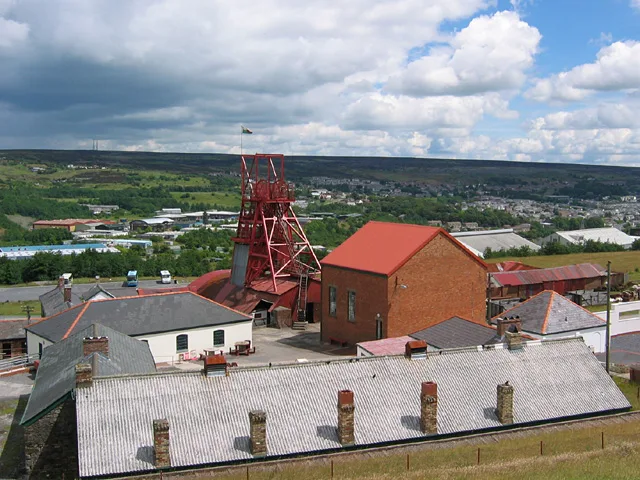
Big Pit National Coal Museum
Museums · 1.0 km

Zion Baptist Chapel
Historic churches · 1.4 km

Pontypool & Blaenavon Railway
Natural landmarks · 1.5 km

Rhymney Brewery & Visitors Centre
Breweries · 1.5 km
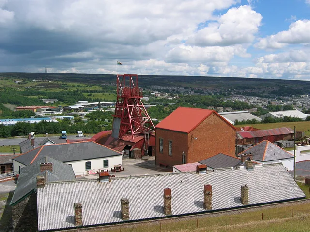
Blaenavon Industrial Landscape
UNESCO World Heritage · 1.7 km

Cefn-Coch
Mountains & hills · 1.8 km

Mynydd James
Mountains & hills · 1.9 km

Gilchrist Memorial
Memorials & monuments · 2.1 km

Mine Winch
Public art & sculpture · 2.1 km
Nearby
📷 5📷 3Historic houses · South Wales
Coity Mawr Cottage Walls
Coity Mawr Cottage Walls — a historic house in South Wales, United Kingdom.
📷 3Historic houses · South Wales
Coity Canol
Coity Canol — a historic house in South Wales, United Kingdom.
📷 5Museums · South Wales
Big Pit National Coal Museum
Big Pit National Coal Museum — former coal mine and industrial heritage museum in Blaenavon in south-east Wales, United Kingdom.
📷 5Historic churches · South Wales
Zion Baptist Chapel
Zion Baptist Chapel — Grade II listed building-listed church in wales-south, United Kingdom.
📷 3Natural landmarks · South Wales
Pontypool & Blaenavon Railway
Pontypool & Blaenavon Railway — a place in South Wales, United Kingdom.
Where to eat & stay near Coity Mountain
Places to stay
 📷 7
📷 7 📷 5
📷 5 📷 5
📷 5 📷 5
📷 5Caravan parks · South Wales
Pen y fan Caravan and Leisure Park
Pen y fan Caravan and Leisure Park — a caravan park in wales south.
 📷 5
📷 5Campsites · South Wales
Pyscodlyn Camping and Caravan Site
Pyscodlyn Camping and Caravan Site — a campsite in wales south.
📷 5Caravan parks · South Wales
Pyscodlyn Camping and Caravan Site
Pyscodlyn Camping and Caravan Site — a caravan park in wales south.
Places to eat & drink
 📷 7
📷 7 📷 5
📷 5Restaurants · South Wales
Little Crown
Little Crown — a restaurant in wales south.
 📷 7
📷 7 📷 5
📷 5Restaurants · South Wales
Sultan of Wales
Sultan of Wales — a restaurant in wales south.
 📷 5
📷 5Restaurants · South Wales
The Walnut Tree
The Walnut Tree — a restaurant in wales south.
 📷 5
📷 5Historic pubs · South Wales
Penllwyn, Former Manor House Now Penllwyn Arms Public House
Penllwyn, Former Manor House Now Penllwyn Arms Public House in Wales South, United Kingdom.
More mountains in this region
 Flagship📷 3
Mountains & hills · South Wales
Milford Haven Waterway
Milford Haven Waterway — ria, or flooded valley, in Pembrokeshire, south-west Wales, UK.
 📷 5
📷 5Mountains & hills · South Wales
Ogof Ffynnon Ddu
Ogof Ffynnon Ddu — cave in the Upper Swansea Valley in South Wales.
 📷 3
📷 3 📷 3
📷 3Frequently asked questions
- Where is Coity Mountain?
- Coity Mountain is in South Wales, United Kingdom (postcode NP4 9XP), in the parish of Blaenavon.
- What is Coity Mountain?
- Coity Mountain — Named summit at 578 m.
- How do I get to Coity Mountain?
- The nearest railway station is Big Pit halt, about 1.2 km away. The nearest town is Argoed. Drivers can use postcode NP4 9XP.
- Is Coity Mountain a protected site?
- Yes — Coity Mountain is part of the River Wye SSSI Site of Special Scientific Interest.
- Is Coity Mountain free to visit?
- Yes, Coity Mountain is free to enter.
- How do I get to Coity Mountain?
- The nearest railway station is Big Pit halt, about 1.2 km away. Drivers can navigate to postcode NP4 9XP.