
Mountains & hills · Scottish Islands
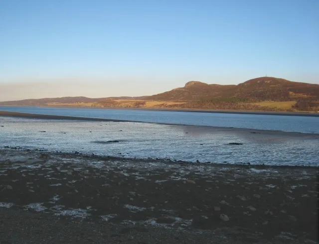
Cnoc an Fhreiceadain
Cnoc an Fhreiceadain — Named summit at 307 m.

Wikimedia Commons contributors — see linked file page for photographer and licence licence

Plan your visit
- Typical visit
- 3 h–8 h
- Best time of year
- Late spring – early autumn (May–Oct)
- Free entry
- Dog-friendly
About
Cnoc an Fhreiceadain is a named summit in the United Kingdom. Wikidata describes it as: "Named summit at 307 m.". Coordinates: 58.5008°, -4.3847°.
Photo gallery
From the Wikipedia article
Cnoc an Fhreiceadain (Hill of Watching or Watch Hill) is a coastal mountain peak in northern Scotland. It is 307 metres (1,007 ft) high with commanding views along the north coast of Scotland to Orkney in the east to Durness and Arkle in the West. It lies in the parish of Tongue with the crofting township of Coldbackie at its foot and looks across the Kyle of Tongue and Tongue Bay to the Rabbit Islands. Cnoc an Fhreiceadain is an Old Red Sandstone conglomerate, and dates from the Paleozoic era, around 400 million years ago. In 2004 as part of the BBC's Top Gear motoring programme, Jeremy Clarkson drove a Land Rover Discovery 3 from sea level to the summit of Cnoc an Fhreiceadain. The programme was criticised by the Mountaineering Council for Scotland for the potential impact of the climb on peat bogs and heather environments.
Excerpt from Wikipedia under CC BY-SA 4.0. See the source article linked in Sources below.
- Coordinates
- 58.5008, -4.3847
- District
- Highland
- Postcode
- IV27 4XP
- Parliamentary constituency
- Caithness, Sutherland and Easter Ross
Sources
- osm: n6806722756 (ODbL)
- wikipedia: Cnoc an Fhreiceadain (CC BY-SA 4.0)
- commons: View of Cnoc an Fhreiceadain across the Kyle of Tongue.jpg (CC BY-SA 4.0)
Other places nearby

Coldbackie
Other places · 0.6 km

Ben Tongue
Mountains & hills · 0.9 km
Ben Tongue
Mountains & hills · 0.9 km

Skullomie
Piers · 1.6 km

Ben Blandy
Mountains & hills · 1.6 km

Skullomie Harbour
Harbours & ports · 2.0 km

Pier, Tongue
Piers · 2.1 km

Tongue House
Historic houses · 2.1 km

Tongue War Memorial
Memorials & monuments · 2.3 km
Tongue Bay
Mountains & hills · 2.3 km

Meall nan Clach Ruadha
Mountains & hills · 2.5 km
Meall nan Clach Ruadha
Mountains & hills · 2.5 km
Nearby
📷 4📷 5Mountains & hills · Scottish Highlands
Ben Tongue
Ben Tongue — mountain in scotland highlands. Elevation: 302 m.
📷 5Mountains & hills · Scottish Highlands
Ben Tongue
Ben Tongue — a hill or mountain in scotland highlands.
📷 4📷 5📷 5Harbours & ports · Scottish Islands
Skullomie Harbour
Skullomie Harbour — a harbour in scotland islands.
Where to eat & stay near Cnoc an Fhreiceadain
Places to stay
 📷 5
📷 5Hostels · Scottish Highlands
Kyle of Tongue Hostel and Holiday Park
Kyle of Tongue Hostel and Holiday Park — a hostel in scotland highlands.
 📷 5
📷 5Campsites · Scottish Islands
Bayview campsite
Bayview campsite — a campsite in scotland islands.
 📷 5
📷 5Caravan parks · Scottish Islands
Craig'Dhu Caravan & Camping Site
Craig'Dhu Caravan & Camping Site — a caravan park in scotland islands.
 📷 5
📷 5 📷 5
📷 5Caravan parks · Scottish Highlands
Choraidh Croft
Choraidh Croft — a caravan park in scotland highlands.
 📷 5
📷 5Hostels · Scottish Islands
Durness Youth Hostel
Durness Youth Hostel — a hostel in scotland islands.
More mountains in this region
 📷 3
📷 3Mountains & hills · Scottish Islands
Acairseid Mhor
Acairseid Mhor — bay in Outer Hebrides, Scotland, UK.
 📷 3
📷 3Mountains & hills · Scottish Islands
Ainshval
Ainshval — Named summit at 781 m.
 📷 3
📷 3 📷 5
📷 5Mountains & hills · Scottish Islands
An Cliseam
An Cliseam — Named summit at 799 m.
Frequently asked questions
- Where is Cnoc an Fhreiceadain?
- Cnoc an Fhreiceadain is in the Scottish Islands, United Kingdom (postcode IV27 4XP).
- What is Cnoc an Fhreiceadain?
- Cnoc an Fhreiceadain — Named summit at 307 m.
- How do I get to Cnoc an Fhreiceadain?
- Drivers can use postcode IV27 4XP.
- Is Cnoc an Fhreiceadain free to visit?
- Yes, Cnoc an Fhreiceadain is free to enter.
- How do I get to Cnoc an Fhreiceadain?
- Drivers can navigate to postcode IV27 4XP. It sits within the Caithness, Sutherland and Easter Ross parliamentary constituency.