
Natural landmarks · North West England
Clougha Pike
In or near Quernmore.
Clougha Pike — mountain in the United Kingdom.

Wikimedia Commons contributors — see linked file page for photographer and licence licence

Plan your visit
- Typical visit
- 1 h–2 h
- Nearest railway station
- Lancaster · 7.5 km
- Free entry
- Dog-friendly
Getting there & planning your visit
To visit Clougha Pike, the nearest railway station is Lancaster, which is 7.5 km away. The postcode for sat-nav is LA2 9EQ, and entry to the site is free.
About
Clougha Pike is a named natural landmark in the United Kingdom. Wikidata describes it as: "mountain in the United Kingdom". Coordinates: 54.0290°, -2.6980°.
Photo gallery
Protected designations
- Site of Special Scientific Interest: Bowland Fells SSSI
- Area of Outstanding Natural Beauty: Forest Of Bowland
Designations sourced from Natural England open data under OGL v3.
From the Wikipedia article
Clougha Pike ( KLUUF-ə) is a hill in the Forest of Bowland in Lancashire, England. From the west it looms over the Conder Valley, the city of Lancaster and Lancaster University. It is visible from as far away as Barrow-in-Furness, South Lakeland mountains such as the Old Man of Coniston, and Blackpool Tower. From the west, it appears to be a large dome shape, with a cliff-like section at the very top. From the south-west, a series of notches or cloughs are visible in its flanks, giving the hill its distinctive name. The notches vary in size and run across the side of the hillside, but not down it. The largest notch has had part of its floor filled in by a small lake and swamp and is a dramatic gritstone boulder-strewn feature. These notches are thought to have been cut by meltwater flowing south-west from the area of Littledale, along the side of a glacier which occupied the Quernmore valley. They are known as marginal notch channels and are among the best examples of these features in Britain. Clougha can be reached from the west, by a pleasant path that travels up its slopes by Rowton (spelt variously) Brook and then diagonally up the final steep broken rock section. It can also be reached from the east from Grit Fell, over boggy land along a muddy path that is sometimes difficult to distinguish. An approach from the north, from the direction of Caton, is also possible. A small car park is also available close to Clougha Pike, just off Rigg Lane. Another starting point to ascend Clougha is from the Victorian folly of Jubilee Tower, where there is also a car park. Its summit furniture includes an Ordnance Survey trig point and two rock wind shelters. The view west from the top is over Morecambe Bay. On a clear day views from Clougha Pike extend to Snowdonia, the Ribble Estuary, the Isle of Man (directly behind Barrow-in-Furness), the fells of the Lake District and many of the Pennine hills. Very rarely, the Mourne Mountains can be seen to the south of the Isle of…
Excerpt from Wikipedia under CC BY-SA 4.0. See the source article linked in Sources below.
- Coordinates
- 54.0290, -2.6980
- County
- Lancashire
- District
- Lancaster
- Parish
- Quernmore
- Postcode
- LA2 9EQ
- Parliamentary constituency
- Morecambe and Lunesdale
- Nearest railway station
- Lancaster — 7.5 km
Sources
- wikidata: Q1102681 (CC0)
- wikipedia: Clougha Pike (CC BY-SA 4.0)
- commons: Trig Pillar, Clougha Pike - geograph.org.uk - 770820.jpg (CC BY-SA 4.0)
Other places nearby
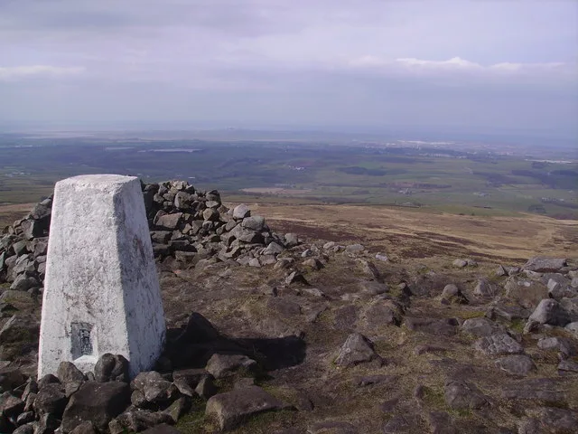
Clougha Pike
Mountains & hills · 0.0 km

Jim Slinn
Memorials & monuments · 0.2 km
Darren Jones
Memorials & monuments · 0.2 km

Grit Fell
Mountains & hills · 1.5 km

The Cragg
Mountains & hills · 2.4 km

Quernmore
Towns & cities · 2.4 km
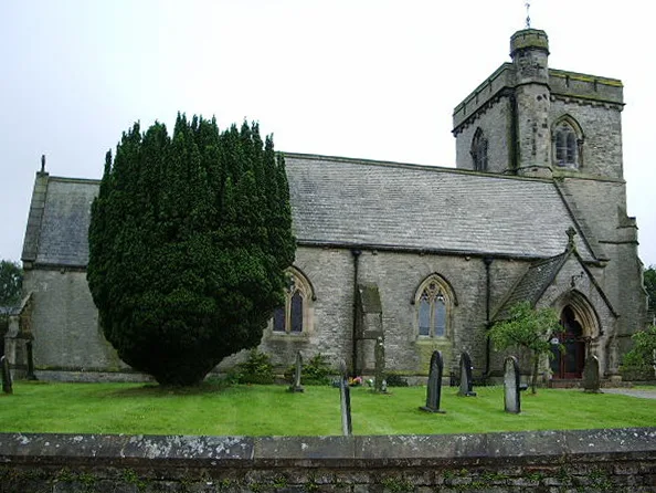
St Peter's Church, Quernmore
Historic churches · 2.7 km

Littledale Scout Camp
Campsites · 3.1 km

Crossghyll Farm Camping Pods
Campsites · 3.2 km

Conder Mill Bridge
Historic bridges · 3.4 km

Littledale Hall
Historic houses · 3.4 km

Whitespout
Waterfalls · 3.7 km
Nearby
📷 3📷 3Memorials & monuments · North West England
Jim Slinn
Jim Slinn — a memorial in england-north-west, United Kingdom.
📷 4Memorials & monuments · North West England
Darren Jones
Darren Jones — a memorial in england-north-west, United Kingdom.
📷 3📷 5Mountains & hills · North West England
The Cragg
The Cragg — mountain in england north west. Elevation: 214 m.
📷 3Towns & cities · North West England
Quernmore
Quernmore — village and civil parish in Lancashire, UK.
Where to eat & stay near Clougha Pike
Places to stay
📷 5Campsites · North West England
Littledale Scout Camp
Littledale Scout Camp — a campsite in england north west.
📷 5Campsites · North West England
Crossghyll Farm Camping Pods
Crossghyll Farm Camping Pods — a campsite in england north west.
 📷 5
📷 5Caravan parks · North West England
Crook O'Lune Caravan Park
Crook O'Lune Caravan Park — a caravan park in england north west.
 📷 5
📷 5Caravan parks · North West England
Glen Tarn Caravan Park
Glen Tarn Caravan Park — a caravan park in england north west.
📷 5Hotels · North West England
Scarthwaite Country House Hotel
Scarthwaite Country House Hotel — a hotel in england north west.
 📷 5
📷 5Caravan parks · North West England
New Parkside Farm Caravan Park
New Parkside Farm Caravan Park — a caravan park in england north west.
Places to eat & drink
 📷 3
📷 3Historic pubs · North West England
The Borough
The Borough — Historic pub — listed building or notable heritage status.
 📷 5
📷 5Historic pubs · North West England
Toll House Inn Hotel
Toll House Inn Hotel — Historic pub — listed building or notable heritage status.
 📷 5
📷 5 📷 7
📷 7 📷 5
📷 5Historic pubs · North West England
Brown Cow Public House
Brown Cow Public House in England North West, United Kingdom.
 📷 7
📷 7Historic pubs · North West England
Ring O' Bells Public House
Ring O' Bells Public House in England North West, United Kingdom.
More natural landmarks in this region
 📷 3
📷 3Natural landmarks · North West England
Statue of Oliver Cromwell
Statue of Oliver Cromwell — Public artwork (statue).
 📷 3
📷 3Natural landmarks · North West England
Dagfields Craft Centre
Dagfields Craft Centre — a other in england-west-midlands, United Kingdom.
 📷 3
📷 3Natural landmarks · North West England
Weaver Valley Cruises
Weaver Valley Cruises — a other in england-west-midlands, United Kingdom.
 📷 3
📷 3Natural landmarks · North West England
Golden Gates
Golden Gates — a other in england-west-midlands, United Kingdom.
Frequently asked questions
- Where is Clougha Pike?
- Clougha Pike is in Lancashire, North-West England, United Kingdom (postcode LA2 9EQ), in the parish of Quernmore.
- What is Clougha Pike?
- Clougha Pike — mountain in the United Kingdom.
- How do I get to Clougha Pike?
- The nearest railway station is Lancaster, about 7.5 km away. Drivers can use postcode LA2 9EQ.
- Is Clougha Pike a protected site?
- Yes — Clougha Pike is part of the Bowland Fells SSSI Site of Special Scientific Interest and the Forest Of Bowland National Landscape (AONB).
- Is Clougha Pike free to visit?
- Yes, Clougha Pike is free to enter.
- How do I get to Clougha Pike?
- The nearest railway station is Lancaster, about 7.5 km away. Drivers can navigate to postcode LA2 9EQ.