
Castles · South West England
Cirencester
In or near South Cerney.
Cirencester ( SY-rən-SEST-ə, occasionally SIS-it-ə) is a market town and civil parish in the Cotswold District of Gloucestershire, England. It lies on the River Churn, a tributary of the Thames. Ci

Neil Owen — CC BY-SA 2.0 via Wikimedia Commons licence

Plan your visit
- Typical visit
- 1.5 h–3 h
- Nearest railway station
- Kemble · 5.9 km
- Free entry
- Family-friendly
- Limited wheelchair access
Getting there & planning your visit
To visit Cirencester Castle, the nearest railway station is Kemble, located 5.9 km away. The postcode for sat-nav is GL7 2NX. Please note that wheelchair accessibility is limited.
About
Cirencester ( SY-rən-SEST-ə, occasionally SIS-it-ə) is a market town and civil parish in the Cotswold District of Gloucestershire, England. It lies on the River Churn, a tributary of the Thames. Cirencester is the eighth largest settlement in Gloucestershire and the largest town within the Cotswolds. It is the home of the Royal Agricultural University, the oldest agricultural college in the English-speaking world, founded in 1840. The town had a population of 20,229 in 2021. The town is 18 miles (29 km) north-west of Swindon, 18 miles (29 km) south-east of Gloucester, 37 miles (60 km) west of Oxford and 39 miles (63 km) north-east of Bristol. The Roman name for the town was Corinium, which is thought to have been associated with the ancient British tribe of the Dobunni, having the same root word as the River Churn. The earliest known reference to the town was by Ptolemy in AD 150. The town's Corinium Museum has an extensive Roman collection.
Photo gallery
360° viewimagery from 2024
Imagery © Mapillary contributors, CC BY-SA 4.0
Official information
Cirencester hosts a variety of markets including weekly Charter Markets, Farmers' Markets, and monthly Arts & Crafts Markets. Visitors can enjoy a vibrant atmosphere with numerous specialty markets and seasonal events throughout the year.
Protected designations
- Site of Special Scientific Interest: Cotswold Water Park SSSI
- Area of Outstanding Natural Beauty: Cotswolds
Designations sourced from Natural England open data under OGL v3.
From the Wikipedia article
Cirencester ( SY-rən-SEST-ə, occasionally SIS-it-ə) is a market town and civil parish in the Cotswold District of Gloucestershire, England. It lies on the River Churn, a tributary of the Thames. Cirencester is the eighth largest settlement in Gloucestershire and the largest town within the Cotswolds. It is the home of the Royal Agricultural University, the oldest agricultural college in the English-speaking world, founded in 1840. The town had a population of 20,229 in 2021. The town is 18 miles (29 km) north-west of Swindon, 18 miles (29 km) south-east of Gloucester, 37 miles (60 km) west of Oxford and 39 miles (63 km) north-east of Bristol. The Roman name for the town was Corinium, which is thought to have been associated with the ancient British tribe of the Dobunni, having the same root word as the River Churn. The earliest known reference to the town was by Ptolemy in AD 150. The town's Corinium Museum has an extensive Roman collection.
Excerpt from Wikipedia under CC BY-SA 4.0. See the source article linked in Sources below.
Background
History
At the end of the 18th century, Cirencester was a thriving market town, at the centre of a network of turnpike roads with easy access to markets for its produce of grain and wool. From 1461, Cirencester Grammar School provided a grammar school education for those who could afford it, and businesses thrived in the town, which was the market town for the surrounding area. In 1789, the opening of the Cirencester branch (or "arm") of the Thames and Severn Canal provided access to markets further afield, by way of a link through the River Thames. In 1841, a branch railway line was opened to Kemble to provide a link to the Great Western Railway at Swindon. The Midland and South Western Junction…
Architecture
The Grade I listed Church of St. John the Baptist is renowned for its Perpendicular Gothic porch, fan vaults and merchants' tombs. The town also has a Roman Catholic church dedicated to St Peter; the foundation stone was laid on 20 June 1895. Coxwell Street to the north of Market Square was the original home of the Baptist Church that was founded in 1651, making it one of the oldest Baptist churches in England; the church moved in January 2017 to a new building on Chesterton Lane. The town's Salvation Army hall in Thomas Street occupies the former Temperance Hall built by the Quaker Christopher Bowly in 1846; it is the oldest such hall in the West of England. The Salvation Army first met in…
Sourced from Wikipedia under CC BY-SA 4.0.
- Coordinates
- 51.7167, -1.9667
- County
- Gloucestershire
- District
- Cotswold
- Parish
- Cirencester
- Postcode
- GL7 2NX
- Parliamentary constituency
- South Cotswolds
- Phone
- +44 1285 655646
- Nearest railway station
- Kemble — 5.9 km
- Official site
- cirencester.gov.uk
Sources
- wikipedia: Cirencester (CC BY-SA 4.0)
Other places nearby

Corn Hall Buildings
Gardens · 0.0 km

The Fleece
Hotels · 0.0 km

Kings Head
Hotels · 0.1 km

Cirencester Markets
Farmers’ markets · 0.1 km

Stud
National landscapes (AONB) · 0.1 km

Cirencester War Memorial
Memorials & monuments · 0.1 km
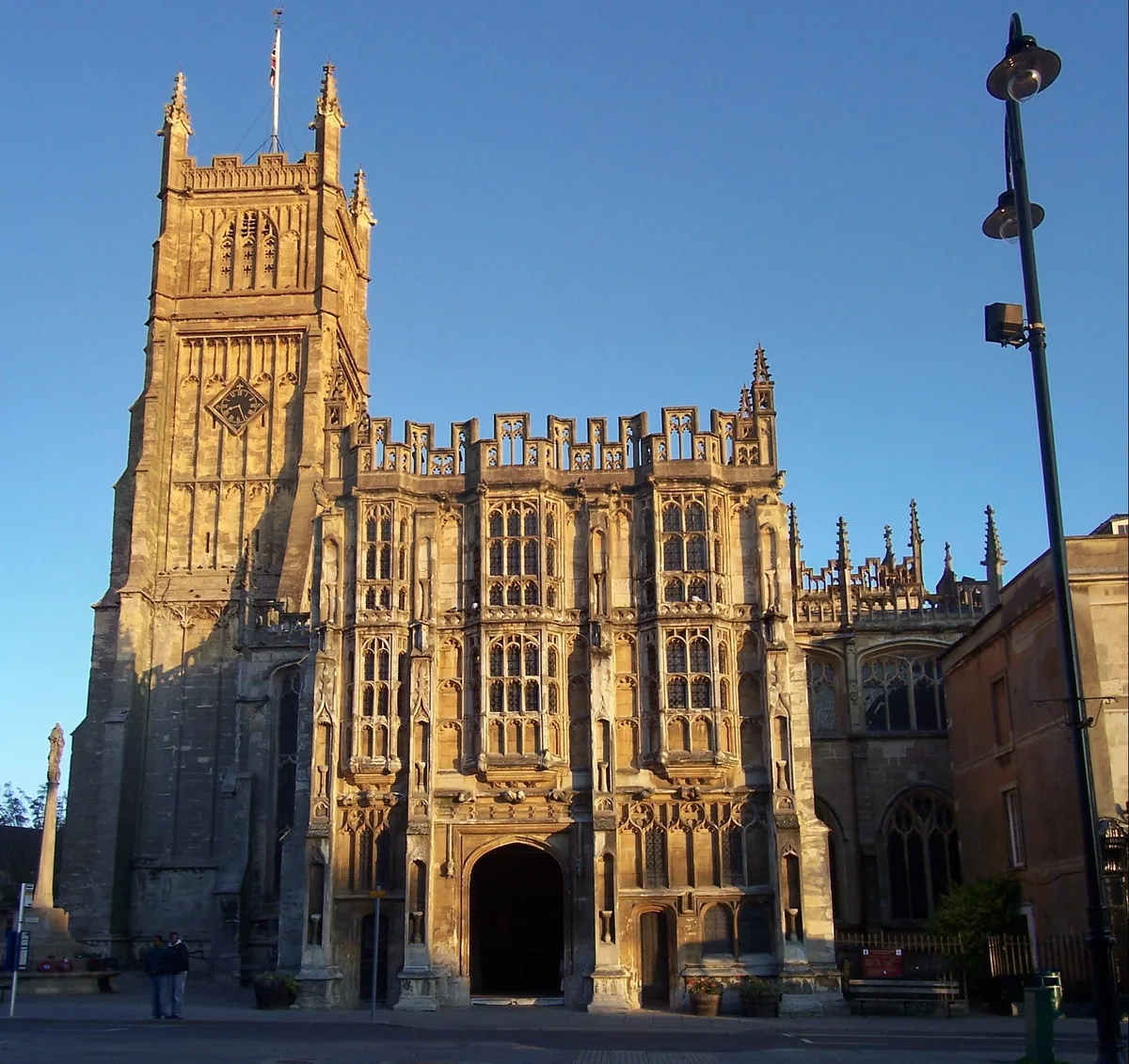
Church of St. John the Baptist, Cirencester
Historic churches · 0.1 km

Pink Lady dancing with big brown Dog
Public art & sculpture · 0.1 km

Hare Mosaic
National landscapes (AONB) · 0.1 km

New Brewery Arts
Open-air theatres · 0.1 km

Horace the Hare
Public art & sculpture · 0.2 km

YHA Cotswolds
Hostels · 0.2 km
Nearby
📷 4Gardens · South West England
Corn Hall Buildings
Corn Hall Buildings — a garden in england-west-midlands, United Kingdom.
📷 7📷 7Hotels · South West England
Kings Head
Kings Head — a hotel in england west midlands.
📷 5Farmers’ markets · South West England
Cirencester Markets
Cirencester Markets — a UK farmers' market in england west midlands.
📷 3National landscapes (AONB) · South West England
Stud
Stud — Public artwork (statue) by Jill Tweed.
📷 3Memorials & monuments · South West England
Cirencester War Memorial
Cirencester War Memorial is a memorial in the United Kingdom.
Where to eat & stay near Cirencester
Places to stay
📷 7📷 7Hotels · South West England
Kings Head
Kings Head — a hotel in england west midlands.
📷 5Hostels · South West England
YHA Cotswolds
YHA Cotswolds — a hostel in england west midlands.
 📷 5
📷 5B&Bs · South West England
The Old Brewhouse
The Old Brewhouse — a bed-and-breakfast in england west midlands.
 📷 5
📷 5Hotels · South West England
The Corinium Hotel And Restaurant
The Corinium Hotel And Restaurant — a hotel in england west midlands.
 📷 5
📷 5Hotels · South West England
Riverside House Hotel
Riverside House Hotel — a hotel in england west midlands.
Places to eat & drink
 📷 7
📷 7Historic pubs · South West England
The Nelson Inn
The Nelson Inn in England South East, United Kingdom.
 📷 5
📷 5Historic pubs · South West England
Golden Farm Public House
Golden Farm Public House in England South East, United Kingdom.
 📷 5
📷 5 📷 7
📷 7Historic pubs · South West England
The Wild Duck Inn
The Wild Duck Inn in England South West, United Kingdom.
 📷 7
📷 7Historic pubs · South West England
The Village Pub
The Village Pub in England South East, United Kingdom.
 📷 5
📷 5Historic pubs · South West England
Horse And Jockey Public House
Horse And Jockey Public House in England South West, United Kingdom.
More castles in this region
 Flagship📷 10
Castles · South West England
Old Wardour Castle
Old Wardour Castle — Grade I listed castle in Wardour, Wiltshire, England, UK.
 📷 5
📷 5Castles · South West England
Ballands Castle
Ballands Castle — former castle in Somerset, England, UK.
 📷 5
📷 5Castles · South West England
Brownsea Castle
Brownsea Castle — grade II listed Device Fort in Purbeck, United Kingdom.
 📷 5
📷 5Castles · South West England
Castle Hill
Castle Hill — castle in Mere, Wiltshire.
Frequently asked questions
- Where is Cirencester?
- Cirencester is in Gloucestershire, the West Midlands, United Kingdom (postcode GL7 2NX), in the parish of Cirencester.
- What is Cirencester?
- Cirencester ( SY-rən-SEST-ə, occasionally SIS-it-ə) is a market town and civil parish in the Cotswold District of Gloucestershire, England. It lies on the River Churn, a tributary of the Thames. Ci
- How do I get to Cirencester?
- The nearest railway station is Kemble, about 5.9 km away. Drivers can use postcode GL7 2NX.
- Is Cirencester a protected site?
- Yes — Cirencester is part of the Cotswold Water Park SSSI Site of Special Scientific Interest and the Cotswolds National Landscape (AONB).
- Does Cirencester charge admission?
- Cirencester typically charges admission. Check the official site for current ticket prices and opening hours.
- How do I get to Cirencester?
- The nearest railway station is Kemble, about 5.9 km away. Drivers can navigate to postcode GL7 2NX.