
Historic churches · North West England
Church of St Bride
In or near Anthorn.
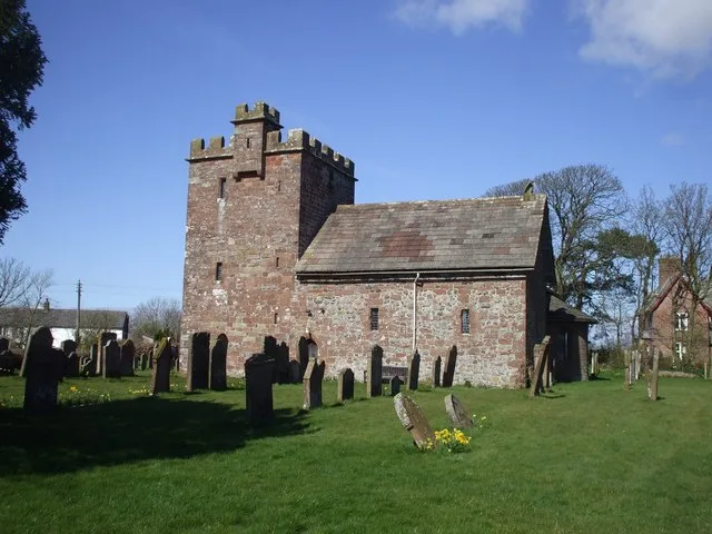
Church of St Bride — church in Kirkbride, Cumberland, Cumbria , England, UK.

Wikimedia Commons contributors — see linked file page for photographer and licence licence

Plan your visit
- Typical visit
- 30 min–1 h
- Nearest railway station
- Wigton · 8.8 km
- Free entry
Getting there & planning your visit
The Church of St Bride is located in Cumberland, postcode CA7 5HR. The nearest railway station is Wigton, which is 8.8 km away. Entry to the church is free.
About
Church of St Bride is a parish church in the Scottish Lowlands. Officially recognised as Grade II* listed building. The site is within the Solway Coast National Landscape (AONB), and is part of the SOUTH SOLWAY MOSSES National Nature Reserve. The nearest railway station is Wigton, about 8.8 km away.
Photo gallery
Heritage listing
Reason for designation: Included and highly graded for its special interest as a medieval church sensitively restored by Prichard and Seddon, which has several good features. History: Small church of classic Norman form with much of the fabric original. The building was restored by Prichard and Seddon in 1856-7. The bell-cote predates the restoration but was added at some time between the late Middle Ages and the C18. The porch was added by Prichard and Seddon when they moved the entrance from south to west. Previously there had been a south porch which is shown on a drawing by Sir Richard Hoare at Clytha Castle. Dr. Peters reported evidence of an intermediate west porch but the rebuilt walling on the south wall looks like Prichard and Seddon s work. The building has changed very little since restoration but it was repaired and re-roofed in the 1990s. This is the church of Monmouthshire s smallest parish, only some 290 acres (117 hectares). Exterior: The church is built of local red sandstone rubble with the Victorian work showing up as more random in character; only the gable copings and the bell-cote are ashlar. The church roof is stone slates, the nave and porch were re-roofed with artificial stone slates in the 1990s. Small nave with west bell-cote, chancel, west porch. The west gable wall of the nave shows a sharp batter to both side and also that the south-west corner is a Victorian rebuild. The porch has a very sharply pointed gable but a much less sharply pointed entrance arch with hollow chamfer and stopped hoodmould, coped gable. The bell-cote is in ashlar and has two arched openings and a gabled top with apex cross. The south wall has a trefoil headed lancet in the rebuilt wall where the south porch was and a 3-light one to the right. The north wall has two 2
From Cadw under OGL v3.
Protected designations
- Site of Special Scientific Interest: Upper Solway Flats & Marshes SSSI
- National Nature Reserve: SOUTH SOLWAY MOSSES
- Area of Outstanding Natural Beauty: Solway Coast
- Ramsar wetland: Upper Solway Flats & Marshes
Designations sourced from Natural England open data under OGL v3.
Place summary
The Church of St Bride is a Grade II* listed building located in the Scottish Lowlands. It is situated within designated areas including the Upper Solway Flats & Marshes SSSI, South Solway Mosses NNR, and the Solway Coast AONB.
AI-generated from the structured facts on this page (operator, designation, listing, era). Not a substitute for visiting.
- Coordinates
- 54.9047, -3.2030
- District
- Cumberland
- Parish
- Kirkbride
- Postcode
- CA7 5HR
- Parliamentary constituency
- Penrith and Solway
- Nearest railway station
- Wigton — 8.8 km
Sources
- wikidata: Q17540774 (CC0)
- commons: Kirkbridechurch.JPG (CC BY-SA 4.0)
Other places nearby

Kirkbride War Memorial
Memorials & monuments · 0.0 km

The Bush Inn
Campsites · 0.3 km

Whitrigg
Villages · 0.6 km

Kirkbride
Villages · 1.3 km

Fingland
Villages · 2.5 km

Newton Arlosh
Villages · 3.6 km

Anthorn
Towns & cities · 3.6 km

Glasson
Villages · 3.7 km
St John the Evangelist's Church, Newton Arlosh
Historic churches · 3.7 km

Cottage and Glendale Holiday Park
Caravan parks · 3.9 km

Glasson Bridge
Historic bridges · 4.1 km

Campfield Marsh Nature Reserve
Forests & woodlands · 4.1 km
Nearby
📷 3Memorials & monuments · North West England
Kirkbride War Memorial
Kirkbride War Memorial — Grade II listed building-listed memorial in scotland-lowlands, United Kingdom.
📷 5Campsites · North West England
The Bush Inn
The Bush Inn — a campsite in scotland lowlands.
📷 5📷 5📷 5📷 5Where to eat & stay near Church of St Bride
Places to stay
📷 5Campsites · North West England
The Bush Inn
The Bush Inn — a campsite in scotland lowlands.
📷 5Caravan parks · North West England
Cottage and Glendale Holiday Park
Cottage and Glendale Holiday Park — a caravan park in scotland lowlands.
 📷 5
📷 5 📷 5
📷 5Caravan parks · North West England
Crofton Hall CL
Crofton Hall CL — a caravan park in scotland lowlands.
 📷 5
📷 5Caravan parks · North West England
Galabank Camping and Caravan Park
Galabank Camping and Caravan Park — a caravan park in scotland lowlands.
 📷 5
📷 5Caravan parks · North West England
Broom Fisheries campsite
Broom Fisheries campsite — a caravan park in scotland lowlands.
Places to eat & drink
 📷 5
📷 5Historic pubs · North West England
Kings Arms Walter Willsons
Kings Arms Walter Willsons in Scotland Lowlands, United Kingdom.
 📷 7
📷 7Historic pubs · North West England
The Greyhound Inn
The Greyhound Inn in Scotland Lowlands, United Kingdom.
 📷 7
📷 7Historic pubs · North West England
Queensberry Arms Hotel
Queensberry Arms Hotel in Scotland Lowlands, United Kingdom.
 📷 5
📷 5Historic pubs · North West England
Horse And Farrier Public House
Horse And Farrier Public House in Scotland Lowlands, United Kingdom.
 📷 5📷 5
More places in this region
 📷 3
📷 3Historic churches · North West England
All Saints Chapel, Somerford
All Saints Chapel, Somerford — church in Cheshire East, Cheshire, England, UK.
 📷 3
📷 3Historic churches · North West England
All Saints Church, Church Lawton
All Saints Church, Church Lawton — Grade II* listed church in Church Lawton, Cheshire East, Cheshire, England, UK.
 📷 3
📷 3Historic churches · North West England
All Saints Church, Scholar Green
All Saints Church, Scholar Green — church in Cheshire East, Cheshire, England, UK.
 📷 3
📷 3Historic churches · North West England
All Saints Church, Siddington
All Saints Church, Siddington — church in Cheshire East, Cheshire, England, UK.
Frequently asked questions
- Where is Church of St Bride?
- Church of St Bride is in the Scottish Lowlands, United Kingdom (postcode CA7 5HR), in the parish of Kirkbride.
- What is Church of St Bride?
- Church of St Bride — church in Kirkbride, Cumberland, Cumbria , England, UK.
- How do I get to Church of St Bride?
- The nearest railway station is Wigton, about 8.8 km away. Drivers can use postcode CA7 5HR.
- Is Church of St Bride a listed building?
- Church of St Bride is officially recognised as Grade II* listed building listed.
- Is Church of St Bride a protected site?
- Yes — Church of St Bride is part of the Upper Solway Flats & Marshes SSSI Site of Special Scientific Interest and the SOUTH SOLWAY MOSSES National Nature Reserve.
- Is Church of St Bride free to visit?
- Yes, Church of St Bride is free to enter.
- How do I get to Church of St Bride?
- Drivers can navigate to postcode CA7 5HR. It sits within the Penrith and Solway parliamentary constituency.