
Forests & woodlands · Mid Wales
Cemaes Head Nature Reserve
Cemaes Head Nature Reserve is a forest or woodland in the United Kingdom.

Wikimedia Commons contributors — see linked file page for photographer and licence licence

Plan your visit
- Typical visit
- 1 h–3 h
- Free entry
- Family-friendly
- Dog-friendly
About
Cemaes Head Nature Reserve is a named forest, woodland or nature reserve in the United Kingdom. Coordinates: 52.1152°, -4.7273°. This entry is part of The Great Britain Guide, a free, ad-free, open-data tourist directory.
Photo gallery
Official information
Cemaes Head is a nature reserve located on the Pembrokeshire coast, known for its steep cliffs and diverse wildlife. Visitors can explore coastal footpaths and observe various seabirds, seals, and other wildlife in their natural habitat.
From the Wikipedia article
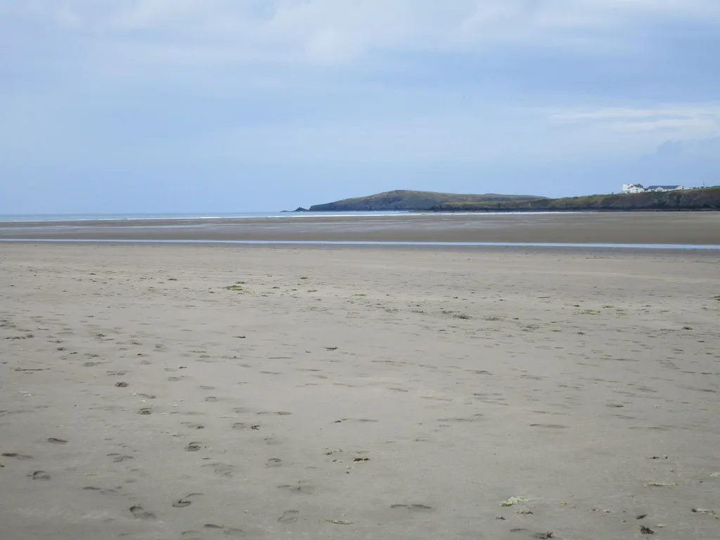
Cemaes Head (formerly Cemais, and historically anglicised as Cemmaes, Kemmaes or Kemmes) (Welsh: Pen Cemaes or Trwyn Cemaes) is a headland and nature reserve in north Pembrokeshire. It lies in the community of St Dogmaels, within the Pembrokeshire Coast National Park. To the west and north it overlooks Cardigan Bay, and to the east Cardigan Island and the estuary of the River Teifi.
Excerpt from Wikipedia under CC BY-SA 4.0. See the source article linked in Sources below.
Background
Description
On the cliff top above the beach of Traeth Godir Coch is an old coastguard lookout post. This was originally built in the 19th century (it is marked on the O.S. map of 1887) and was subsequently enlarged seawards in World War II by the addition of a brick wide-windowed extension. At the same time the main doorway was enlarged and edged with the same red brick. The site was accessed via a track and footpath from Pengarn, ½ mile to the south-east and from Alltycoed Farm upon whose land it lies. This was one of hundreds of wartime coastal lookouts which kept watch for enemy aircraft and submarines; the oil storage tanks at Milford Haven were only a short flight from here, and during the war…
Visiting
Cemaes Head lies on the 186 mi Pembrokeshire Coast Path, close to its northern end. This is itself part of the much longer 870 mi Wales Coast Path. The remote section of path over Cemaes Head from Poppit Sands to Ceibwr Bay is some 5½ miles long, with a considerable amount of ascent and descent. All stiles and gates on the Pembrokeshire Coast Path are numbered from north to south; the stile on Cemaes Head carries the number 1. It is possible to drive up part of Cemaes Head on the lane from Poppit Sands. This lane accesses a couple of private properties near the top, and stops at Allt y Coed campsite, some ¼ mile short of the furthest point of the coastal path; there is car parking available…
Sourced from Wikipedia under CC BY-SA 4.0.
- Coordinates
- 52.1152, -4.7273
- District
- Pembrokeshire
- Parish
- St. Dogmaels
- Postcode
- SA43 3LP
- Parliamentary constituency
- Ceredigion Preseli
- Official site
- www.welshwildlife.org
Sources
- osm: w827438084 (ODbL)
- wikipedia: Cemaes Head (CC BY-SA 4.0)
- commons: Poppit Sands and Cemaes Head.jpg (CC BY-SA 4.0)
Other places nearby

Alltycoed Campsite
Campsites · 0.5 km

Traeth Godir-coch
Beaches · 0.7 km

Pen Garn
Mountains & hills · 1.3 km

Pengarn
Mountains & hills · 1.3 km

Landing Place, Cei Bach
Marinas · 1.4 km

YHA Poppit Sands
Hostels · 1.5 km

Cei-bâch / Little Quay
Beaches · 1.5 km

Cippyn Fach Burnt Mound
Archaeological sites · 1.8 km

Wern-Ddu Burnt Mound
Archaeological sites · 1.8 km

Cardigan
Natural landmarks · 1.9 km
Poppit Sands
Beaches · 2.2 km

Cardigan Lifeboat Station
Beaches · 2.2 km
Nearby
📷 5Campsites · Mid Wales
Alltycoed Campsite
Alltycoed Campsite — a campsite in wales mid.
📷 3📷 5📷 3📷 5📷 5Where to eat & stay near Cemaes Head Nature Reserve
Places to stay
📷 5Campsites · Mid Wales
Alltycoed Campsite
Alltycoed Campsite — a campsite in wales mid.
📷 5 📷 5
📷 5Caravan parks · Mid Wales
Cardigan Bay Holiday Park
Cardigan Bay Holiday Park — a caravan park in wales mid.
 📷 5
📷 5 📷 5
📷 5Caravan parks · Mid Wales
Patch Caravan Park
Patch Caravan Park — a caravan park in wales mid.
 📷 5
📷 5Places to eat & drink
 📷 3
📷 3Historic pubs · Mid Wales
Bar 45
Bar 45 — Historic pub — listed building or notable heritage status.
 📷 5
📷 5Historic pubs · Mid Wales
The Grosvenor
The Grosvenor — Historic pub — listed building or notable heritage status.
 📷 5
📷 5Restaurants · Mid Wales
Fusion Bar and Restaurant
Fusion Bar and Restaurant — a restaurant in wales mid.
 📷 4
📷 4Historic pubs · Mid Wales
Cardiff Arms
Cardiff Arms — Historic pub — listed building or notable heritage status.
 📷 3
📷 3Historic pubs · Mid Wales
The Pendre Inn
The Pendre Inn — Historic pub — listed building or notable heritage status.
 📷 5
📷 5More forests in this region
 📷 3
📷 3Forests & woodlands · Mid Wales
Cardigan Island / Ynys Aberteifi
Cardigan Island / Ynys Aberteifi is a forest or woodland in the United Kingdom.
 📷 3
📷 3Forests & woodlands · Mid Wales
Coed Rheidol National Nature Reserve
Coed Rheidol National Nature Reserve is a forest or woodland in the United Kingdom.
 📷 5
📷 5Forests & woodlands · Mid Wales
Coedmor National Nature Reserve
Coedmor National Nature Reserve is a forest or woodland in the United Kingdom.
 📷 3
📷 3Forests & woodlands · Mid Wales
Cors Dyfi Nature Reserve
Cors Dyfi Nature Reserve is a forest or woodland in the United Kingdom.
Frequently asked questions
- Where is Cemaes Head Nature Reserve?
- Cemaes Head Nature Reserve is in Mid Wales, United Kingdom (postcode SA43 3LP), in the parish of St. Dogmaels.
- What is Cemaes Head Nature Reserve?
- Cemaes Head Nature Reserve is a forest or woodland in the United Kingdom.
- How do I get to Cemaes Head Nature Reserve?
- Drivers can use postcode SA43 3LP.
- Is Cemaes Head Nature Reserve free to visit?
- Yes, Cemaes Head Nature Reserve is free to enter.
- How do I get to Cemaes Head Nature Reserve?
- Drivers can navigate to postcode SA43 3LP. It sits within the Ceredigion Preseli parliamentary constituency.