Mountains & hills · Scottish Lowlands
Carlin's Cairn
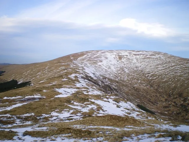
Carlin's Cairn — mountain in scotland lowlands. Elevation: 807 m.

Colin Kinnear — CC BY-SA 2.0 via Wikimedia Commons licence
Plan your visit
- Typical visit
- 3 h–8 h
- Best time of year
- Late spring – early autumn (May–Oct)
About
Carlin's Cairn is a mountain located in scotland lowlands. Elevation: 807 m. A named British peak recorded in OpenStreetMap. Peaks are typically named on Ordnance Survey 1:50k mapping.
Photo gallery
Place summary
Carlin's Cairn is a mountain located in the Scottish Lowlands. It is known for its distinctive shape and prominent position in the landscape. The area offers opportunities for outdoor activities such as hiking and exploring the surrounding natural scenery. Visitors can expect a rugged terrain typical of the region, making it suitable for those interested in experiencing the Scottish outdoors.
AI-generated from the structured facts on this page (operator, designation, listing, era). Not a substitute for visiting.
- Coordinates
- 55.1667, -4.3612
Sources
- osm: n8299808500 (ODbL)
- wikidata: Q86280811 (CC0)
Other places nearby
Loading nearby places…
Nearby
📷 5Mountains & hills · Scottish Lowlands
Carlin's Cairn
Carlin's Cairn — a hill or mountain in scotland lowlands.
 📷 5
📷 5Mountains & hills · Scottish Lowlands
Craigrine
Craigrine — mountain in scotland lowlands. Elevation: 709 m.
 📷 3
📷 3Natural landmarks · Scottish Lowlands
Corserine
Corserine — 814m high mountain in Dumfries and Galloway, Scotland, UK.
 📷 3
📷 3Mountains & hills · Scottish Lowlands
Corserine
Corserine — Named summit at 814 m.
📷 5Mountains & hills · Scottish Lowlands
Craignelder
Craignelder — mountain in scotland lowlands. Elevation: 610 m.
 📷 5
📷 5Mountains & hills · Scottish Lowlands
Meikle Craigtarson
Meikle Craigtarson — mountain in scotland lowlands. Elevation: 620 m.
Where to eat & stay near Carlin's Cairn
Places to stay
 📷 5
📷 5Caravan parks · Scottish Lowlands
Loch Doon Caravan Park
Loch Doon Caravan Park — a caravan park in scotland lowlands.
 📷 5
📷 5Campsites · Scottish Lowlands
Otter Pool "Stay the night"
Otter Pool "Stay the night" — a campsite in scotland lowlands.
 📷 5
📷 5Campsites · Scottish Lowlands
Glentrool Camping & Caravan Site
Glentrool Camping & Caravan Site — a campsite in scotland lowlands.
 📷 5
📷 5Hostels · Scottish Lowlands
Minigaff Youth Hostel
Minigaff Youth Hostel — a hostel in scotland lowlands.
 📷 5
📷 5Hotels · Scottish Lowlands
Cree Bridge House Hotel
Cree Bridge House Hotel — a hotel in scotland lowlands.
 📷 5
📷 5Campsites · Scottish Lowlands
Creebridge Caravan Park
Creebridge Caravan Park — a campsite in scotland lowlands.

More mountains in this region
 📷 3
📷 3Mountains & hills · Scottish Lowlands
Andrewhinney Hill
Andrewhinney Hill — Named summit at 677 m.
 📷 3
📷 3Mountains & hills · Scottish Lowlands
Arbory Hill
Arbory Hill — Named summit at 429 m.
 📷 3
📷 3Mountains & hills · Scottish Lowlands
Auchenton Hill ( East Mount Lowther)
Auchenton Hill ( East Mount Lowther) — Named summit at 631 m.
 📷 3
📷 3Mountains & hills · Scottish Lowlands
Bakestall
Bakestall — Named summit at 673.5 m.
Frequently asked questions
- Where is Carlin's Cairn?
- Carlin's Cairn is in the Scottish Lowlands, United Kingdom.
- What is Carlin's Cairn?
- Carlin's Cairn — mountain in scotland lowlands. Elevation: 807 m.
- How do I get to Carlin's Cairn?
- Its coordinates are 55.1667°, -4.3612°.