
Historic bridges · East of England
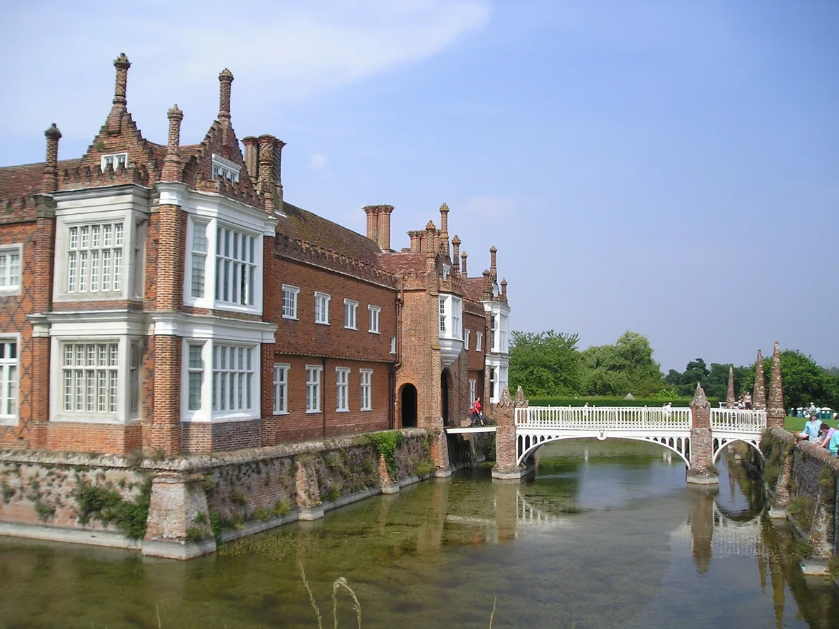
Bridge, About 300 Metres East Of Helmingham Hall
In or near Pettaugh.
Bridge, About 300 Metres East Of Helmingham Hall — Grade II listed building-listed bridge in england-east, United Kingdom.

Geographer — CC BY-SA 2.0 via Wikimedia Commons licence

Plan your visit
- Typical visit
- 15 min–30 min
- Free entry
- Dog-friendly
About
Bridge, About 300 Metres East Of Helmingham Hall is a Grade II listed building-listed bridge in england-east, United Kingdom, registered on the National Heritage List for England (NHLE entry 1033075). Listed status protects buildings and structures of special architectural or historic interest. See the linked Wikipedia article for further details.
Photo gallery
Heritage listing
Details TM 15 NE 4/90 HELMINGHAM HELMINGHAM PARK Bridge, about 300m east of Helmingham Hall GV II Bridge, probably c.1800 as part of works carried out at Helmingham Hall by John Nash. Red brick. Causeway about 4m wide. Tall semicircular arch, spanning a small stream. Parapets about 1m high with gabled brick copings; the parapets are splayed outwards at the approaches. Square terminal piers; these have pyramid finials with coped gables at the base, in a similar manner to the bridge piers in the moat surrounding Helmingham Hall. The bridge carries a path leading from Helmingham Hall to the Parish Church and is an important landscape feature of the Park. Listing NGR: TM1895857666 Legacy The contents of this record have been generated from a legacy data system. Legacy System number: 279709 Legacy System: LBS
From the Historic England List Entry under OGL v3.
Protected designations
- Area of Outstanding Natural Beauty: Suffolk Coast & Heaths
Designations sourced from Natural England open data under OGL v3.
Place summary
The bridge, located about 300 metres east of Helmingham Hall in the East of England, is a Grade II listed building. It is recognised for its architectural significance and historical importance within the landscape.
AI-generated from the structured facts on this page (operator, designation, listing, era). Not a substitute for visiting.
- Coordinates
- 52.1738, 1.2008
- County
- Suffolk
- District
- Mid Suffolk
- Parish
- Helmingham
- Postcode
- IP14 6EQ
- Parliamentary constituency
- Central Suffolk and North Ipswich
Sources
- wikidata: Q26284538 (CC0)
Other places nearby

Church of St Mary, Helmingham
Historic churches · 0.1 km
Helmingham Hall
Stately homes · 0.3 km

Helmingham Hall Gardens
Gardens · 0.4 km

Obelisk, About 750 Metres West Of Helmingham Hall
Forts · 1.1 km

Framsden Village Sign
Public art & sculpture · 1.9 km

Framsden
Villages · 2.0 km

Webster's Mill, Framsden
Mills · 2.1 km

Otley Hall
Historic houses · 2.2 km

Framsden War Memorial
Memorials & monuments · 2.3 km

Otley
Villages · 2.8 km

Otley Village Sign
Public art & sculpture · 2.8 km

Framsden Hall
Historic houses · 2.9 km
Nearby
📷 3Historic churches · East of England
Church of St Mary, Helmingham
Church of St Mary, Helmingham — a Grade I-listed church in england-east, United Kingdom.
📷 3Stately homes · East of England
Helmingham Hall
Helmingham Hall — country house in Helmingham, Suffolk, England, UK.
📷 3Gardens · East of England
Helmingham Hall Gardens
Helmingham Hall Gardens — gardens in Helmingham Hall, United Kingdom.
📷 5Forts · East of England
Obelisk, About 750 Metres West Of Helmingham Hall
Obelisk, About 750 Metres West Of Helmingham Hall — a martello broad in england-east, United Kingdom.
📷 3Public art & sculpture · East of England
Framsden Village Sign
Framsden Village Sign — a public art in england-east, United Kingdom.
📷 5Where to eat & stay near Bridge, About 300 Metres East Of Helmingham Hall
Places to stay
 📷 5
📷 5Campsites · East of England
Broughton Hall Caravan Club CL
Broughton Hall Caravan Club CL — a campsite in england east.
 📷 7
📷 7Hotels · East of England
Limes Hotel
Limes Hotel — a hotel in england east.
 📷 5
📷 5 📷 5
📷 5 📷 7
📷 7 📷 5
📷 5Places to eat & drink
 📷 7
📷 7Historic pubs · East of England
The Greyhound, Gosbeck
The Greyhound, Gosbeck in England East, United Kingdom.
 📷 5
📷 5Historic pubs · East of England
New Bell Public House
New Bell Public House in England East, United Kingdom.
 📷 5
📷 5Historic pubs · East of England
The Red Lion, Debenham
The Red Lion, Debenham in England East, United Kingdom.
 📷 7
📷 7 📷 5
📷 5Historic pubs · East of England
Castle Public House
Castle Public House in England East, United Kingdom.
 📷 5
📷 5Historic pubs · East of England
The Swan Inn, Worlingworth
The Swan Inn, Worlingworth in England East, United Kingdom.
More bridges in this region
.JPG?width=1200) 📷 5
📷 5Historic bridges · East of England
Albert Bridge
Albert Bridge is a historic bridge in the United Kingdom.
.jpg?width=1200) 📷 5
📷 5Historic bridges · East of England
Bedford Town Bridge
Bedford Town Bridge is a historic bridge in the United Kingdom.
 📷 5
📷 5Historic bridges · East of England
Bethnal Green and King's Lynn Line
Bethnal Green and King's Lynn Line is a historic bridge in the United Kingdom.
 📷 5
📷 5Historic bridges · East of England
Bethnal Green and King's Lynn Line
Bethnal Green and King's Lynn Line is a historic bridge in the United Kingdom.
Frequently asked questions
- Where is Bridge, About 300 Metres East Of Helmingham Hall?
- Bridge, About 300 Metres East Of Helmingham Hall is in Suffolk, East of England, United Kingdom (postcode IP14 6EQ), in the parish of Helmingham.
- What is Bridge, About 300 Metres East Of Helmingham Hall?
- Bridge, About 300 Metres East Of Helmingham Hall — Grade II listed building-listed bridge in england-east, United Kingdom.
- How do I get to Bridge, About 300 Metres East Of Helmingham Hall?
- The nearest town is Pettaugh. Drivers can use postcode IP14 6EQ.
- Is Bridge, About 300 Metres East Of Helmingham Hall a listed building?
- Bridge, About 300 Metres East Of Helmingham Hall is officially recognised as Grade II listed building listed.
- Is Bridge, About 300 Metres East Of Helmingham Hall a protected site?
- Yes — Bridge, About 300 Metres East Of Helmingham Hall is part of the Suffolk Coast & Heaths National Landscape (AONB).
- Is Bridge, About 300 Metres East Of Helmingham Hall free to visit?
- Yes, Bridge, About 300 Metres East Of Helmingham Hall is free to enter.
- How do I get to Bridge, About 300 Metres East Of Helmingham Hall?
- Drivers can navigate to postcode IP14 6EQ. It sits within the Central Suffolk and North Ipswich parliamentary constituency.