Natural landmarks · North West England
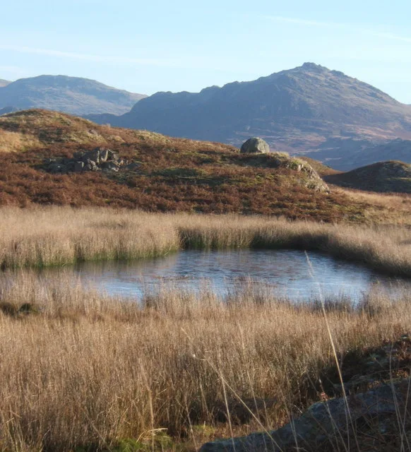
Blea Tarn
In or near Boot.
Blea Tarn — lake in Eskdale, Cumbria, United Kingdom.

Wikimedia Commons contributors — see linked file page for photographer and licence licence
Plan your visit
- Typical visit
- 1 h–2 h
- Nearest railway station
- Beckfoot · 0.7 km
- Free entry
- Dog-friendly
Getting there & planning your visit
To visit Blea Tarn, the nearest railway station is Beckfoot, located 0.7 km away. The postcode for navigation is CA19 1TF, and entry to the site is free.
About
Blea Tarn is a named natural landmark in the United Kingdom. Wikidata describes it as: "lake in Eskdale, Cumbria, United Kingdom". Coordinates: 54.3980°, -3.2870°.
Photo gallery
From the Wikipedia article
Blea Tarn is a lake in Eskdale, Cumbria, in the English Lake District, located about half a mile north of Beckfoot. Located at an elevation of 217 m (712 ft), the lake has an area of 3.3 hectares (8.2 acres) and measures 277 m × 150 m (909 ft × 492 ft), with a maximum depth of 11 m (36 ft). There are other lakes called "Blea Tarn" in the Lake District (in Borrowdale and Little Langdale). John Taylor commented in 1905 that in the ... days when place-names were being given, the inhabitants of one of our secluded valleys were so cut off from their fellows that they would call a rock Eagle Crag or a small sheet of water Blea Tarn, quite unaware that on the other side of the hill the same titles were being afiixed to other cliffs and waters.
Excerpt from Wikipedia under CC BY-SA 4.0. See the source article linked in Sources below.
- Coordinates
- 54.3980, -3.2870
- District
- Cumberland
- Parish
- Eskdale
- Postcode
- CA19 1TF
- Parliamentary constituency
- Barrow and Furness
- Nearest railway station
- Beckfoot — 0.7 km
Sources
- wikidata: Q4925708 (CC0)
- wikipedia: Blea Tarn (Eskdale) (CC BY-SA 4.0)
- commons: Blea Tarn. - geograph.org.uk - 145573.jpg (CC BY-SA 4.0)
Other places nearby
Blind Tarn
Natural landmarks · 0.3 km
Siney Tarn
Natural landmarks · 0.4 km

Blea Tarn Hill
Mountains & hills · 0.5 km

Eskdale War Memorial
Memorials & monuments · 0.8 km

Nab Gill Iron Mine
Viewpoints · 1.0 km

Bridge Over Whillan Beck To South West Of Corn Mill
Historic bridges · 1.1 km

Boot
Towns & cities · 1.1 km

Eskdale Mill
Museums · 1.1 km
Eskdale Corn Mill
Watermills · 1.1 km

Eskdale Campsite
Campsites · 1.3 km
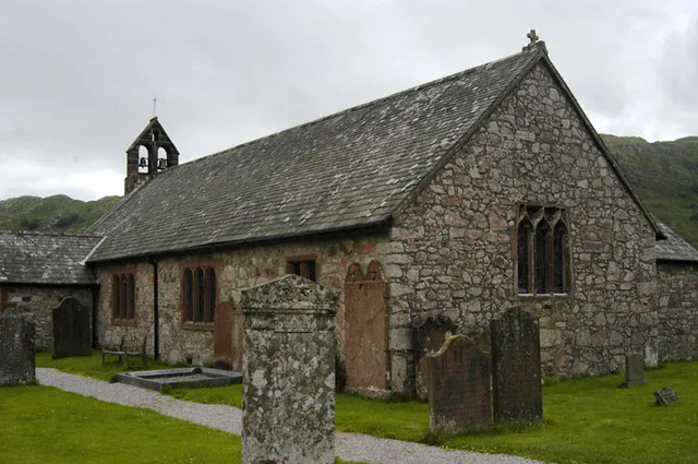
St Catherine's Church, Boot
Historic churches · 1.3 km

Fisherground Campsite
Campsites · 1.4 km
Nearby
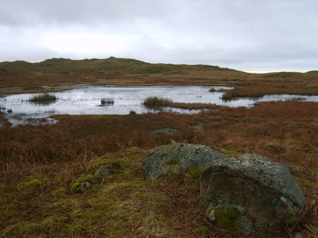
📷 3Natural landmarks · North West England
Blind Tarn
Blind Tarn — lake in Eskdale, Cumbria, England, UK.
📷 3📷 5Mountains & hills · North West England
Blea Tarn Hill
Blea Tarn Hill — mountain in england north west. Elevation: 290 m.
📷 3Memorials & monuments · North West England
Eskdale War Memorial
Eskdale War Memorial — Grade II listed building-listed memorial in england-north-west, United Kingdom.
📷 3Viewpoints · North West England
Nab Gill Iron Mine
Nab Gill Iron Mine is a viewpoint in the United Kingdom.
📷 3Historic bridges · North West England
Bridge Over Whillan Beck To South West Of Corn Mill
Bridge Over Whillan Beck To South West Of Corn Mill — Grade II listed building-listed bridge in england-north-west, United Kingdom.
Where to eat & stay near Blea Tarn
Places to stay
📷 5Campsites · North West England
Eskdale Campsite
Eskdale Campsite — a campsite in england north west.
📷 5Campsites · North West England
Fisherground Campsite
Fisherground Campsite — a campsite in england north west.
 📷 5
📷 5Hostels · North West England
YHA Eskdale
YHA Eskdale — a hostel in england north west.
 📷 5
📷 5Hostels · North West England
YHA Wasdale Hall
YHA Wasdale Hall — a hostel in england north west.
 📷 5
📷 5Campsites · North West England
The Barn Campsite
The Barn Campsite — a campsite in england north west.
 📷 5
📷 5Campsites · North West England
Church Stile Farm And Holiday Park
Church Stile Farm And Holiday Park — a campsite in england north west.
Places to eat & drink
 📷 5
📷 5Historic pubs · North West England
Blacksmiths Arms
Blacksmiths Arms in England North West, United Kingdom.
 📷 7
📷 7Historic pubs · North West England
Church House Public House
Church House Public House in England North West, United Kingdom.
 📷 5
📷 5Restaurants · North West England
The Terrace Coffee House and Restaurant
The Terrace Coffee House and Restaurant — a restaurant in england north west. Cuisine: sandwich;lunch.
 📷 7
📷 7Cafés · North West England
Grange Bridge Cottage
Grange Bridge Cottage — a café in england north east.
 📷 7
📷 7Historic pubs · North West England
The Travellers Rest
The Travellers Rest in England North West, United Kingdom.
 📷 5
📷 5Historic pubs · North West England
Sun Cottage Sun Inn Public House
Sun Cottage Sun Inn Public House in England North West, United Kingdom.
More natural landmarks in this region
 📷 3
📷 3Natural landmarks · North West England
Statue of Oliver Cromwell
Statue of Oliver Cromwell — Public artwork (statue).
 📷 3
📷 3Natural landmarks · North West England
Dagfields Craft Centre
Dagfields Craft Centre — a other in england-west-midlands, United Kingdom.
 📷 3
📷 3Natural landmarks · North West England
Weaver Valley Cruises
Weaver Valley Cruises — a other in england-west-midlands, United Kingdom.
 📷 3
📷 3Natural landmarks · North West England
Golden Gates
Golden Gates — a other in england-west-midlands, United Kingdom.
Frequently asked questions
- Where is Blea Tarn?
- Blea Tarn is in North-West England, United Kingdom (postcode CA19 1TF), in the parish of Eskdale.
- What is Blea Tarn?
- Blea Tarn — lake in Eskdale, Cumbria, United Kingdom.
- How do I get to Blea Tarn?
- The nearest railway station is Beckfoot, about 0.7 km away. Drivers can use postcode CA19 1TF.
- Is Blea Tarn free to visit?
- Yes, Blea Tarn is free to enter.
- How do I get to Blea Tarn?
- The nearest railway station is Beckfoot, about 0.7 km away. Drivers can navigate to postcode CA19 1TF.