Parks · North East England
Bishopwearmouth Burn
In or near Sunderland.
Bishopwearmouth Burn in England North East, United Kingdom.

Alexander P Kapp — CC BY-SA 2.0 via Wikimedia Commons licence
Plan your visit
- Typical visit
- 1 h–2 h
- Nearest railway station
- University · 1.3 km
- Free entry
- Family-friendly
- Dog-friendly
Getting there & planning your visit
To visit Bishopwearmouth Burn, the nearest railway station is University, located 1.3 km away. The postcode for sat-nav is SR4 7PZ, and entry to the park is free.
About
Bishopwearmouth Burn is a place of interest in England North East, United Kingdom — drawn from open-data sources for visitor reference. See the linked Wikipedia article for the full description.
Photo gallery
Protected designations
- Site of Special Scientific Interest: Durham Coast SSSI
Designations sourced from Natural England open data under OGL v3.
From the Wikipedia article
Bishopwearmouth Burn or the Barnes Burn is a stream flowing through the city of Sunderland. A tributary of the River Wear, the stream originates between Thorney Close and Hastings Hill farm. It proceeds to run through Barnes Park and its extensions before going underground due to modern housing and again unculverts briefly at Burn Park, and meeting the river at what was Bishopwearmouth, where it was also referred to as the "Rector's Gill".
Excerpt from Wikipedia under CC BY-SA 4.0. See the source article linked in Sources below.
- Coordinates
- 54.8946, -1.4076
- District
- Sunderland
- Parish
- Sunderland, unparished area
- Postcode
- SR4 7PZ
- Parliamentary constituency
- Sunderland Central
- Nearest railway station
- University — 1.3 km
Sources
- wikidata: Q106808146 (CC0)
- wikipedia: Bishopwearmouth Burn (CC BY-SA 4.0)
Other places nearby
City of Sunderland College
Other places · 0.2 km

Barnes
Parks · 0.3 km

Barnes Park
Parks · 0.4 km

Humbledon Hill
Mountains & hills · 0.5 km

Defended settlement on Humbledon Hill
Archaeological sites · 0.5 km
Defended settlement on Humbledon Hill
Vineyards · 0.5 km
St. Mary's Roman Catholic School, Sunderland
Historic churches · 0.7 km

The Lodge
Cafés · 0.7 km

Plains Farm
Farms (open to visitors) · 0.8 km

Plaque to commemorate civilians killed in World War II
Memorials & monuments · 0.9 km

Bishopwearmouth Cemetery
Cemeteries · 1.0 km

Thornhill School
Historic houses · 1.0 km
Nearby
📷 3Other places · North East England
City of Sunderland College
City of Sunderland College in England North East, United Kingdom.
📷 3📷 4📷 5Mountains & hills · North East England
Humbledon Hill
Humbledon Hill — mountain in scotland lowlands. Elevation: 96 m.
📷 3Archaeological sites · North East England
Defended settlement on Humbledon Hill
Defended settlement on Humbledon Hill — a archaeological in scotland-lowlands, United Kingdom.
📷 5Vineyards · North East England
Defended settlement on Humbledon Hill
Defended settlement on Humbledon Hill — a UK vineyard in scotland lowlands, producing English or Welsh wine from cool-climate grape varieties.
Where to eat & stay near Bishopwearmouth Burn
Places to stay
 📷 5
📷 5Hotels · North East England
Hilton Garden Inn Sunderland
Hilton Garden Inn Sunderland — a hotel in scotland lowlands. 3-star. Brand: Hilton Garden Inn.
 📷 5
📷 5Caravan parks · North East England
Showmen's Guild Site - Sunnyside Farm
Showmen's Guild Site - Sunnyside Farm — a caravan park in scotland lowlands.
 📷 5
📷 5Caravan parks · North East England
Lizard Lane Caravan Park
Lizard Lane Caravan Park — a caravan park in scotland lowlands.
 📷 5
📷 5Hotels · North East England
Bowes Incline Hotel
Bowes Incline Hotel — a hotel in scotland lowlands.
 📷 5
📷 5 📷 5
📷 5Caravan parks · North East England
Plum Tree Park
Plum Tree Park — a caravan park in scotland lowlands.
Places to eat & drink
📷 5 📷 5
📷 5Historic pubs · North East England
Mountain Daisy Public House
Mountain Daisy Public House in England North East, United Kingdom.
 📷 6
📷 6Historic pubs · North East England
Fitzgerald's Public House
Fitzgerald's Public House in England North East, United Kingdom.
 📷 5
📷 5Historic pubs · North East England
Livingstone's Public House
Livingstone's Public House in England North East, United Kingdom.
 📷 5
📷 5Historic pubs · North East England
Greens Public House
Greens Public House in England North East, United Kingdom.
 📷 5
📷 5Historic pubs · North East England
The Dun Cow Public House
The Dun Cow Public House in England North East, United Kingdom.
More parks in this region
 📷 3
📷 3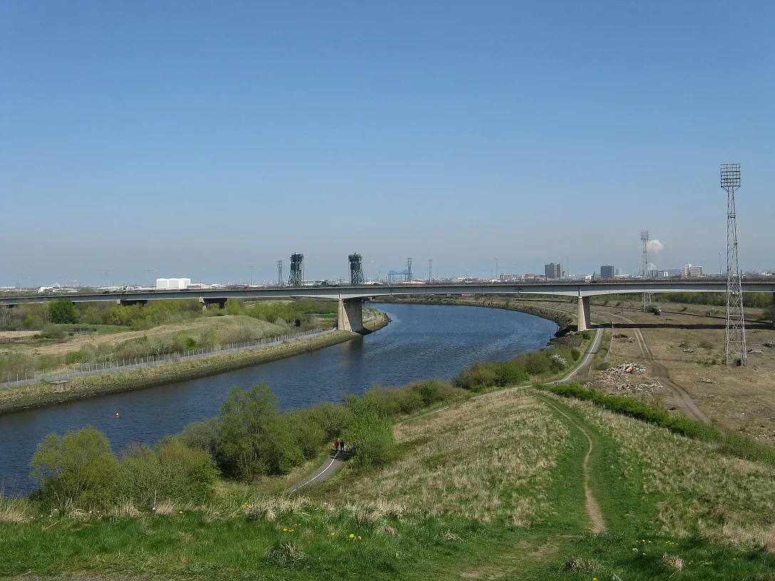 📷 4
📷 4Parks · North East England
Maze Park Nature Reserve
Maze Park Nature Reserve — park in Middlesbrough, United Kingdom.
 📷 3
📷 3Parks · North East England
Portrack Incinerator
Portrack Incinerator — former waste and power plant in England.
 📷 3
📷 3Parks · North East England
Preston Park, Stockton-on-Tees
Preston Park, Stockton-on-Tees — public park in north eastern England.
Frequently asked questions
- Where is Bishopwearmouth Burn?
- Bishopwearmouth Burn is in North-East England, United Kingdom (postcode SR4 7PZ), in the parish of Sunderland, unparished area.
- What is Bishopwearmouth Burn?
- Bishopwearmouth Burn in England North East, United Kingdom.
- How do I get to Bishopwearmouth Burn?
- The nearest railway station is University, about 1.3 km away. Drivers can use postcode SR4 7PZ.
- Is Bishopwearmouth Burn a protected site?
- Yes — Bishopwearmouth Burn is part of the Durham Coast SSSI Site of Special Scientific Interest.
- Is Bishopwearmouth Burn free to visit?
- Yes, Bishopwearmouth Burn is free to enter.
- How do I get to Bishopwearmouth Burn?
- The nearest railway station is University, about 1.3 km away. Drivers can navigate to postcode SR4 7PZ.