
Beaches · South West England
Bigbury-on-Sea
In or near Kingston.
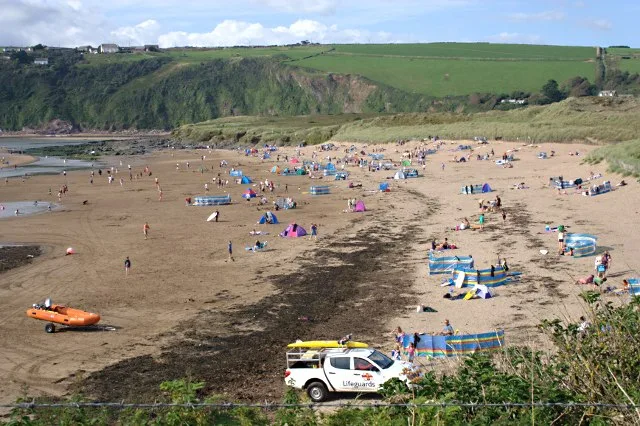
Bigbury-on-Sea is a village in the South Hams district on the south coast of Devon, England. It is part of the civil parish of Bigbury which is centred on a small village of that name about a mile inl

Derek Harper — CC BY-SA 2.0 via Wikimedia Commons licence

Plan your visit
- Typical visit
- 1 h–3 h
- Best time of year
- Summer (Jun–Aug)
- Nearest railway station
- Kingsbridge Ria End · 8.5 km
- Free entry
- Family-friendly
- Dog-friendly
Getting there & planning your visit
To visit Bigbury-on-Sea, the nearest railway station is Kingsbridge Ria End, located 8.5 km away. Entry to the beach is free. The postcode for sat-nav is TQ7 4AU.
About
Bigbury-on-Sea is a village in the South Hams district on the south coast of Devon, England. It is part of the civil parish of Bigbury which is centred on a small village of that name about a mile inland. At the 2021 census, the parish had a population of 564, which was slightly more than the 500 recorded at the 2011 census. Bigbury-on-Sea village is on the coast above the largest sandy beach in South Devon facing south to Bigbury Bay. The tidal island of Burgh Island lies about 270 yards (250 metres) offshore. At the start of the 20th century Bigbury-on-Sea consisted of a few fishermen's cottages with fish cellars. The village grew with the growth in holidaymaking and now has a beach cafe, and by the mainland side of causeway is the Burgh Island Causeway resort built in 1998 replacing the burnt out fishermen's cottages after a controversial planning application. The resort is made up of privately owned and holiday let flats and a private leisure club with indoor pool and gym. The Devon Coastal Path runs behind the resort. The large sandy beach is very popular for wave and wind based water sports, but it lost its Blue Flag beach status in 2012 due to water quality issues. There are two large car parks with easy access to the beaches and the walk across the sand bar to Burgh Island with its Art Deco Hotel and Pilchard Inn. When the tide covers the sand bar access is by the sea tractor. As of March 2020, 63% of properties in the village were holiday-lets or second homes.
Photo gallery
Protected designations
- Area of Outstanding Natural Beauty: South Devon
Designations sourced from Natural England open data under OGL v3.
From the Wikipedia article
Bigbury-on-Sea is a village in the South Hams district on the south coast of Devon, England. It is part of the civil parish of Bigbury which is centred on a small village of that name about a mile inland. At the 2021 census, the parish had a population of 564, which was slightly more than the 500 recorded at the 2011 census. Bigbury-on-Sea village is on the coast above the largest sandy beach in South Devon facing south to Bigbury Bay. The tidal island of Burgh Island lies about 270 yards (250 metres) offshore. At the start of the 20th century Bigbury-on-Sea consisted of a few fishermen's cottages with fish cellars. The village grew with the growth in holidaymaking and now has a beach cafe, and by the mainland side of causeway is the Burgh Island Causeway resort built in 1998 replacing the burnt out fishermen's cottages after a controversial planning application. The resort is made up of privately owned and holiday let flats and a private leisure club with indoor pool and gym. The Devon Coastal Path runs behind the resort. The large sandy beach is very popular for wave and wind based water sports, but it lost its Blue Flag beach status in 2012 due to water quality issues. There are two large car parks with easy access to the beaches and the walk across the sand bar to Burgh Island with its Art Deco Hotel and Pilchard Inn. When the tide covers the sand bar access is by the sea tractor. As of March 2020, 63% of properties in the village were holiday-lets or second homes.
Excerpt from Wikipedia under CC BY-SA 4.0. See the source article linked in Sources below.
- Coordinates
- 50.2840, -3.8947
- County
- Devon
- District
- South Hams
- Parish
- Bigbury
- Postcode
- TQ7 4AU
- Parliamentary constituency
- South Devon
- Nearest railway station
- Kingsbridge Ria End — 8.5 km
Sources
- wikipedia: Bigbury-on-Sea (CC BY-SA 4.0)
Other places nearby

Warren Point
Viewpoints · 0.2 km

Sedgewell Cove
Beaches · 0.3 km

Bigbury Beach
Beaches · 0.4 km

Challaborough Beach
Beaches · 0.5 km

Burgh Island Hotel
Historic houses · 0.5 km

Fisherman's Gardens
Viewpoints · 0.5 km

River Avon, Devon
Museums · 0.7 km

Fisherman’s Lookout
Viewpoints · 0.7 km

Challaborough Bay Holiday Park
Caravan parks · 0.8 km

Bigbury Bay Holiday Park
Caravan parks · 0.8 km

Mount Folly Farm
Campsites · 0.9 km
Bantham beach
Beaches · 1.0 km
Nearby
📷 3📷 3📷 5📷 5Beaches · South West England
Challaborough Beach
Challaborough Beach is a beach in the United Kingdom.
📷 4Historic houses · South West England
Burgh Island Hotel
Burgh Island Hotel — a Grade II*-listed historic house in england-south-west, United Kingdom.
📷 5Viewpoints · South West England
Fisherman's Gardens
Fisherman's Gardens is a viewpoint in the United Kingdom.
Where to eat & stay near Bigbury-on-Sea
Places to stay
📷 5Caravan parks · South West England
Challaborough Bay Holiday Park
Challaborough Bay Holiday Park — a caravan park in england south west. Brand: Parkdean Resorts.
📷 5Caravan parks · South West England
Bigbury Bay Holiday Park
Bigbury Bay Holiday Park — a caravan park in england south west.
📷 5 📷 5
📷 5Campsites · South West England
Higher Aunemouth Camping
Higher Aunemouth Camping — a campsite in england south west.
 📷 2
📷 2Caravan parks · South West England
North Upton Caravan and Camp Site
North Upton Caravan and Camp Site — a caravan park in england south west.
 📷 5
📷 5Places to eat & drink
 📷 7
📷 7Historic pubs · South West England
The Old Chapel Inn
The Old Chapel Inn in England South West, United Kingdom.
 📷 6
📷 6 📷 7
📷 7Historic pubs · South West England
White Hart Hotel And The Assembly Rooms
White Hart Hotel And The Assembly Rooms in England South West, United Kingdom.
 📷 7
📷 7Historic pubs · South West England
King Of Prussia Inn
King Of Prussia Inn in England South West, United Kingdom.
 📷 7
📷 7 📷 5
📷 5More beaches in this region
 📷 5
📷 5Beaches · South West England
Alum Chine Beach
Alum Chine Beach is a beach in the United Kingdom.
 📷 5
📷 5Beaches · South West England
Bournemouth Beach
Bournemouth Beach — beach in Bournemouth, Dorset, UK.
 📷 5
📷 5Beaches · South West England
Bournemouth East Beach
Bournemouth East Beach is a beach in the United Kingdom.
 📷 5
📷 5Beaches · South West England
Bournemouth West Beach
Bournemouth West Beach is a beach in the United Kingdom.
Frequently asked questions
- Where is Bigbury-on-Sea?
- Bigbury-on-Sea is in Devon, South-West England, United Kingdom (postcode TQ7 4AU), in the parish of Bigbury.
- What is Bigbury-on-Sea?
- Bigbury-on-Sea is a village in the South Hams district on the south coast of Devon, England. It is part of the civil parish of Bigbury which is centred on a small village of that name about a mile inl
- How do I get to Bigbury-on-Sea?
- The nearest railway station is Kingsbridge Ria End, about 8.5 km away. Drivers can use postcode TQ7 4AU.
- Is Bigbury-on-Sea a protected site?
- Yes — Bigbury-on-Sea is part of the South Devon National Landscape (AONB).
- Is Bigbury-on-Sea free to visit?
- Yes, Bigbury-on-Sea is free to enter.
- How do I get to Bigbury-on-Sea?
- Drivers can navigate to postcode TQ7 4AU. It sits within the South Devon parliamentary constituency.