
Mountains & hills · Scottish Highlands
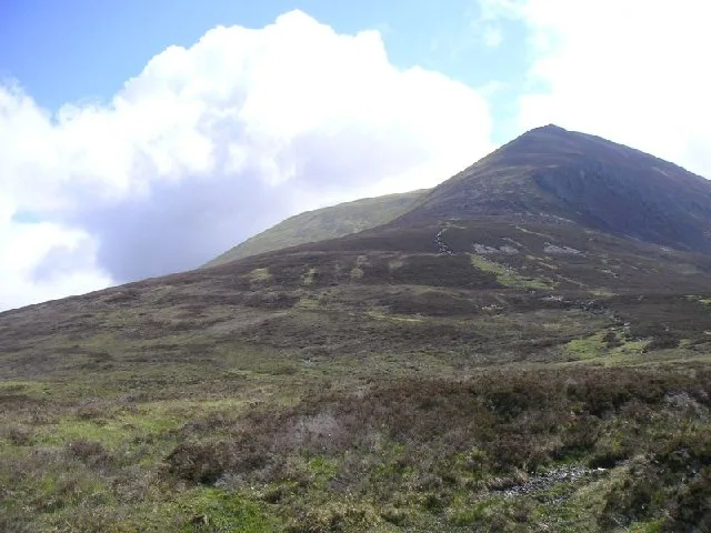
Ben Wyvis
Also known as: Glas Leathad Mòr
In or near Strathpeffer.
Ben Wyvis — Named summit at 1046 m.

Wikimedia Commons contributors — see linked file page for photographer and licence licence

Plan your visit
- Typical visit
- 3 h–8 h
- Best time of year
- Late spring – early autumn (May–Oct)
- Nearest railway station
- Garve · 9.8 km
- Free entry
- Dog-friendly
Getting there & planning your visit
To visit Ben Wyvis in the Scottish Highlands, the nearest railway station is Garve, located 9.8 km away. Entry to the mountain is free.
About
Ben Wyvis is a named summit in the United Kingdom. Also known as: Glas Leathad Mòr. Wikidata describes it as: "Named summit at 1046 m.". Coordinates: 57.6790°, -4.5792°.
Photo gallery
Official information
Ben Wyvis is a prominent Munro located in Easter Ross, known for its distinctive shape and popularity among hikers. Visitors can enjoy various routes to the summit, offering stunning panoramic views and the opportunity for mountain biking in the surrounding areas.
From the Wikipedia article
Ben Wyvis (Scottish Gaelic: Beinn Uais) is a mountain in Easter Ross, in the northern Highlands of Scotland. It lies north-west of Dingwall, in the council area of Highland, and the county of Ross and Cromarty. Ben Wyvis is a large winding and undulating ridge running roughly north–south for about 5 km, the highest point of which is Glas Leathad Mòr at 1,046 metres (3,432 ft). Geologically, the ridge is composed of Moine pelitic gneiss. The mountain is prominent in views of the area, presenting a whale-back shape above the farmland of Strathconon. Ben Wyvis is an important habitat for several species of plants and birds, and is designated as a National Nature Reserve (NNR), a Special Protection Area (SPA), a Special Area of Conservation (SAC), and a Site of Special Scientific Interest (SSSI). Of particular importance is the woolly hair-moss that covers the summit plateau. This springy moss provides ideal nesting territory for dotterel that breed here each summer: Ben Wyvis represents at least 2.4% of the breeding population in Great Britain.
Excerpt from Wikipedia under CC BY-SA 4.0. See the source article linked in Sources below.
Background
History
Ben Wyvis stands on the northern edge of historic lands of Clan Munro. By tradition, the Munros held their land from the Crown. The king declared that they held their lands on condition of furnishing a snowball at midsummer if required. This condition they could easily fulfil, as snow was to be found in some of the mountain corries of their property all year round. The Battle of Bealach nam Broig was fought between rival clans near the pass that separates Ben Wyvis from the lower summit of Carn Mòr, which lies to the northwest. Clans from lands to the north-west who were allied to Clan Mackenzie fought against north-eastern clans (including Clan Munro) who supported the Earl of Ross. The…
Visiting
Ben Wyvis is usually climbed from the west, starting just south of Garbat on the A835 road, where there is a car park maintained by Forestry and Land Scotland. The path follows the north bank of the Allt a' Bhealaich Mhòir through the forest, before entering the NNR. From here the route ascends more steeply to reach An Cabar, the southernmost of the summits that lie along the main ridge. An alternative route, also accessed from the car park, takes in the Top of Tom a' Choinnich, which lies to the north of the main summit: the two routes can be combined to make a circular route. During the 1980s there were proposals for the construction of downhill skiing infrastructure on Ben Wyvis.
Sourced from Wikipedia under CC BY-SA 4.0.
- Coordinates
- 57.6790, -4.5792
- Address
- Easter Ross, Scotland
- Nearest railway station
- Garve — 9.8 km
- Official site
- www.walkhighlands.co.uk
Sources
- osm: n268248292 (ODbL)
- wikipedia: Ben Wyvis (CC BY-SA 4.0)
- commons: An Cabar - geograph.org.uk - 22555.jpg (CC BY-SA 4.0)
Other places nearby

Glas Leathad Mòr
Mountains & hills · 0.0 km
Ben Wyvis
Natural landmarks · 0.0 km

Ben Wyvis - Glas Leathad Mor
Mountains & hills · 0.0 km

An t-Socach
Mountains & hills · 0.7 km

An t-Socach
Mountains & hills · 0.8 km

Ben Wyvis National Nature Reserve
Forests & woodlands · 1.4 km

Tom a' Chòinnich
Mountains & hills · 1.6 km

Tom a' Chòinnich
Mountains & hills · 1.6 km
Tom a' Choinnich
Mountains & hills · 1.6 km

An Cabar
Mountains & hills · 2.2 km

An Cabar
Mountains & hills · 2.3 km

Queen's Cairn
Mountains & hills · 3.6 km
Nearby
📷 3Mountains & hills · Scottish Highlands
Glas Leathad Mòr
Glas Leathad Mòr — a mountain in scotland-highlands, United Kingdom, 1046 m.
📷 5Natural landmarks · Scottish Highlands
Ben Wyvis
Ben Wyvis — mountain in Highland, Scotland, UK.
📷 5Mountains & hills · Scottish Highlands
Ben Wyvis - Glas Leathad Mor
Ben Wyvis - Glas Leathad Mor — a hill or mountain in scotland highlands.
📷 2Mountains & hills · Scottish Highlands
An t-Socach
An t-Socach — a mountain in scotland-highlands, United Kingdom.
📷 5Mountains & hills · Scottish Highlands
An t-Socach
An t-Socach — mountain in scotland highlands. Elevation: 1006 m.
📷 5Forests & woodlands · Scottish Highlands
Ben Wyvis National Nature Reserve
Ben Wyvis National Nature Reserve is a forest or woodland in the United Kingdom.
Where to eat & stay near Ben Wyvis
Places to stay
 📷 5
📷 5B&Bs · Scottish Highlands
Holly Lodge
Holly Lodge — a bed-and-breakfast in scotland highlands.
 📷 5
📷 5Campsites · Scottish Highlands
Riverside Campsite
Riverside Campsite — a campsite in scotland highlands.
 📷 5
📷 5Caravan parks · Scottish Highlands
Dingwall Camping and Caravanning Club
Dingwall Camping and Caravanning Club — a caravan park in scotland highlands.
 📷 5
📷 5Campsites · Scottish Highlands
Black Rock Holiday Park
Black Rock Holiday Park — a campsite in scotland highlands.
 📷 7
📷 7Hotels · Scottish Highlands
Conon Bridge Hotel
Conon Bridge Hotel — a hotel in scotland highlands.
 📷 5
📷 5Hostels · Scottish Highlands
Fairburn Activity Centre
Fairburn Activity Centre — a hostel in scotland highlands.
Places to eat & drink
📷 5Historic pubs · Scottish Highlands
Holly Lodge Hotel, Strathpeffer
Holly Lodge Hotel, Strathpeffer in Scotland Highlands, United Kingdom.
 📷 7
📷 7Historic pubs · Scottish Highlands
Commercial Bar, 84 High Street, Invergordon
Commercial Bar, 84 High Street, Invergordon in Scotland Highlands, United Kingdom.
More mountains in this region
 📷 3
📷 3Mountains & hills · Scottish Highlands
A' Bhuidheanach Bheag
A' Bhuidheanach Bheag — Named summit at 936 m.
 📷 3
📷 3 📷 3
📷 3 📷 3
📷 3Frequently asked questions
- Where is Ben Wyvis?
- Ben Wyvis is in the Scottish Highlands, United Kingdom.
- What is Ben Wyvis?
- Ben Wyvis — Named summit at 1046 m.
- How do I get to Ben Wyvis?
- The nearest railway station is Garve, about 9.8 km away. Its coordinates are 57.6790°, -4.5792°.
- Is Ben Wyvis free to visit?
- Yes, Ben Wyvis is free to enter.