
Natural landmarks · Central Scotland
Beinn Challuim
Also known as: Ben Challum, Beinn Chaluim
In or near Crianlarich.
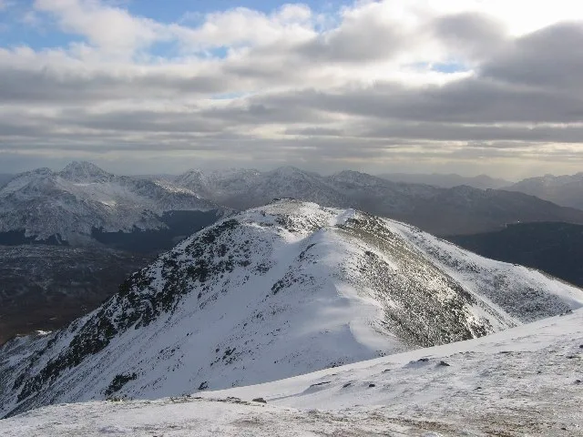
Beinn Challuim — 1025m high mountain in Stirling, Scotland, UK.

Wikimedia Commons contributors — see linked file page for photographer and licence licence

Plan your visit
- Typical visit
- 1 h–2 h
- Nearest railway station
- Upper Tyndrum · 5.7 km
- Free entry
- Dog-friendly
About
Beinn Challuim is a named natural landmark in the United Kingdom. Wikidata describes it as: "1025m high mountain in Stirling, Scotland, UK". Coordinates: 56.4546°, -4.6192°.
Photo gallery
Official information
Ben Challum is a mountain located in Argyll, typically approached from Strath Fillan. While the ascent from this direction is considered unremarkable, the views from the summit and its conical shape from the Glen Lochay side are noteworthy.
From the Wikipedia article
Beinn Challuim (English: Ben Challum) is a mountain in the Breadalbane region of the Scottish Highlands. It is east of the village of Tyndrum, in the Forest of Mamlorn, an ancient deer forest at the northern edge of Loch Lomond and the Trossachs National Park. It is a Munro with a height of 1,025 metres (3,363 ft).
Excerpt from Wikipedia under CC BY-SA 4.0. See the source article linked in Sources below.
Background
Description
With a height of 1025 metres (3363 feet) and a prominence of 450 metres (1480 feet) Ben Challuim qualifies as a Munro and a Marilyn. It stands at the head of Glen Lochay and is a prominent peak when seen from the head of that glen, its western slopes dominate the north eastern side of Strath Fillan. When seen from the south the summit of the mountain cannot be seen, being hidden behind the south top. The mountain name was originally written as Beinn Challuim before Ben Challum became the norm. However in recent years the Ordnance Survey have reverted to using the original name on their maps. The name translates as "Callum's mountain", which could refer to Saint Columba who is known in…
Sourced from Wikipedia under CC BY-SA 4.0.
- Coordinates
- 56.4546, -4.6192
- Address
- Stirling, Scotland
- Nearest railway station
- Upper Tyndrum — 5.7 km
- Official site
- www.walkhighlands.co.uk
Sources
- wikidata: Q3397111 (CC0)
- wikipedia: Beinn Challuim (CC BY-SA 4.0)
- commons: Summit ridge of Beinn Challuim - geograph.org.uk - 7745.jpg (CC BY-SA 4.0)
Other places nearby
Beinn Chaluim
Mountains & hills · 0.0 km

Beinn Challuim South Top
Mountains & hills · 0.7 km

Ben Challum South Top
Mountains & hills · 0.7 km

Cam Chreag
Mountains & hills · 2.6 km

Beinn Chaorach
Mountains & hills · 2.9 km
Beinn Chaorach
Mountains & hills · 2.9 km

Creag Mhor - Stob nan Clach
Mountains & hills · 2.9 km

Forest of Mamlorn
Battlefields & battle sites · 2.9 km

Stob nan Clach
Mountains & hills · 2.9 km

Beinn nan Imirean
Mountains & hills · 3.3 km

Beinn nan Imirean
Mountains & hills · 3.5 km
Sròn nan Eun
Mountains & hills · 3.6 km
Nearby
📷 5Mountains & hills · Central Scotland
Beinn Chaluim
Beinn Chaluim — Named summit at 1025 m.
📷 5Mountains & hills · Central Scotland
Beinn Challuim South Top
Beinn Challuim South Top — a hill or mountain in scotland highlands.
📷 3Mountains & hills · Central Scotland
Ben Challum South Top
Ben Challum South Top — a mountain in scotland-highlands, United Kingdom.
📷 3Mountains & hills · Central Scotland
Cam Chreag
Cam Chreag — a mountain in scotland-highlands, United Kingdom.
📷 5Mountains & hills · Central Scotland
Beinn Chaorach
Beinn Chaorach — a hill or mountain in scotland highlands.
📷 5Mountains & hills · Central Scotland
Beinn Chaorach
Beinn Chaorach — mountain in scotland highlands. Elevation: 818 m.
Where to eat & stay near Beinn Challuim
Places to stay
 📷 5
📷 5Campsites · Central Scotland
Strathfillan Wigwams
Strathfillan Wigwams — a campsite in scotland highlands.
 📷 5
📷 5Caravan parks · Central Scotland
Tyndrum Holiday Park
Tyndrum Holiday Park — a caravan park in scotland highlands.
 📷 5
📷 5Campsites · Central Scotland
By the Way
By the Way — a campsite in scotland highlands.
📷 5📷 5📷 5Places to eat & drink
 📷 5
📷 5Historic pubs · Central Scotland
The Drovers Inn
The Drovers Inn — Historic pub — listed building or notable heritage status.
More natural landmarks in this region
 📷 4
📷 4Natural landmarks · Central Scotland
Blackadder Water
Blackadder Water in England North East, United Kingdom.
 📷 3
📷 3Natural landmarks · Central Scotland
A6105 road
A6105 road in England North East, United Kingdom.
 📷 3
📷 3 📷 3
📷 3Frequently asked questions
- Where is Beinn Challuim?
- Beinn Challuim is in the Scottish Highlands, United Kingdom.
- What is Beinn Challuim?
- Beinn Challuim — 1025m high mountain in Stirling, Scotland, UK.
- How do I get to Beinn Challuim?
- The nearest railway station is Upper Tyndrum, about 5.7 km away. Its coordinates are 56.4546°, -4.6192°.
- Is Beinn Challuim free to visit?
- Yes, Beinn Challuim is free to enter.
- How do I get to Beinn Challuim?
- The nearest railway station is Upper Tyndrum, about 5.7 km away.