
Natural landmarks · Central Scotland
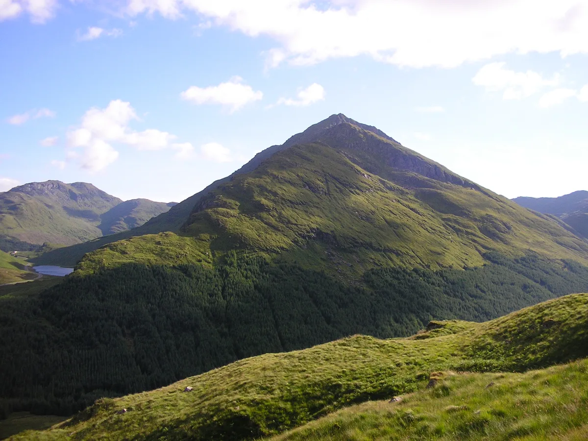
Beinn an Lochain
In or near Cairndow.
Beinn an Lochain — 901m high mountain in Argyll and Bute, Scotland, UK.

Wikimedia Commons contributors — see linked file page for photographer and licence licence

Plan your visit
- Typical visit
- 1 h–2 h
- Nearest railway station
- Arrochar and Tarbet · 9.9 km
- Free entry
- Dog-friendly
Getting there & planning your visit
To visit Beinn an Lochain, the nearest railway station is Arrochar and Tarbet, located 9.9 km away. Entry is free.
About
Beinn an Lochain is a named natural landmark in the United Kingdom. Heritage designation: Site of Special Scientific Interest. Part of Arrochar Alps. Wikidata describes it as: "901m high mountain in Argyll and Bute, Scotland, UK". Coordinates: 56.2301°, -4.8762°.
Photo gallery
From the Wikipedia article
Beinn an Lochain is a mountain in the Arrochar Alps in western Scotland. A Corbett, reaching 901.7 metres (2,958 ft), Beinn an Lochain is situated within the Argyll Forest Park, which is itself within the Loch Lomond and the Trossachs National Park. Although included in Sir Hugh Munro's original list of Scottish mountains over 3,000 feet (914.4 metres) summit elevation, subsequent surveys showed it to be significantly shorter than this. Nonetheless, it remains a popular mountain, and is often quoted as an example of an interesting mountain below the Munro threshold to show that there is more to mountaineering in Scotland than just Munro-bagging. Beinn an Lochain is usually climbed from the car park at Butter Bridge, on the A83, in Glen Kinglas. From there, the summit is reached after a 2.5-kilometre (1+1⁄2 mi) walk along the mountain's north-east ridge, climbing over 700 metres (2,300 ft). The mountain trail offers views of Loch Restil and the pass between Glen Croe and Glen Kinglas.
Excerpt from Wikipedia under CC BY-SA 4.0. See the source article linked in Sources below.
- Coordinates
- 56.2301, -4.8762
- Address
- Cowal, Argyll and Bute, Scotland
- Nearest railway station
- Arrochar and Tarbet — 9.9 km
Sources
- wikidata: Q41214 (CC0)
- wikipedia: Beinn an Lochain (CC BY-SA 4.0)
- commons: Beinn an lochain.jpg (CC BY-SA 4.0)
Other places nearby
Beinn an Lochain
Mountains & hills · 0.1 km

Loch Restil
National parks · 1.1 km

A83 road
Reservoirs & lochs · 1.3 km

Rest And Be Thankful Memorial Stone
Memorials & monuments · 1.3 km
Rest And Be Thankful Memorial Stone, Glen Croe
Memorials & monuments · 1.3 km

Rest And Be Thankful
Viewpoints · 1.4 km

Beinn an t-Seilich
Mountains & hills · 1.7 km

Glen Kinglas
Castles · 1.8 km
Beinn an t-Seilich
Mountains & hills · 1.8 km

Easain Duibh
Waterfalls · 1.9 km

Butter Bridge
Historic bridges · 2.3 km
Beinn Luibhean
Mountains & hills · 2.5 km
Nearby
📷 3📷 5📷 4Reservoirs & lochs · Central Scotland
A83 road
A83 road in Scotland Islands, United Kingdom.
📷 3Memorials & monuments · Central Scotland
Rest And Be Thankful Memorial Stone
Rest And Be Thankful Memorial Stone — a memorial in scotland-highlands, United Kingdom.
📷 5Memorials & monuments · Central Scotland
Rest And Be Thankful Memorial Stone, Glen Croe
Rest And Be Thankful Memorial Stone, Glen Croe — category C listed building-listed memorial in scotland-highlands, United Kingdom.
📷 4Viewpoints · Central Scotland
Rest And Be Thankful
Rest And Be Thankful is a viewpoint in the United Kingdom.
Where to eat & stay near Beinn an Lochain
Places to stay
 📷 5
📷 5Caravan parks · Central Scotland
Honeymoon Bridge
Honeymoon Bridge — a caravan park in scotland highlands.
 📷 5
📷 5Caravan parks · Central Scotland
Stay the Night Ardgartan
Stay the Night Ardgartan — a caravan park in scotland highlands.
 📷 5
📷 5Campsites · Central Scotland
Lochgoilhead Scout Camp
Lochgoilhead Scout Camp — a campsite in scotland highlands.
 📷 5
📷 5Caravan parks · Central Scotland
Lochgoilhead Holiday Park
Lochgoilhead Holiday Park — a caravan park in scotland highlands.
 📷 3
📷 3Campsites · Central Scotland
Coilessan camping permit area March-September
Coilessan camping permit area March-September — a campsite in scotland highlands.
 📷 5
📷 5Campsites · Central Scotland
MacTavish Campsite
MacTavish Campsite — a campsite in scotland highlands.
Places to eat & drink
 📷 5
📷 5Historic pubs · Central Scotland
The Drovers Inn
The Drovers Inn — Historic pub — listed building or notable heritage status.
 📷 3
📷 3Historic pubs · Central Scotland
Ardbrecknish House
Ardbrecknish House — Historic pub — listed building or notable heritage status.
More natural landmarks in this region
 📷 4
📷 4Natural landmarks · Central Scotland
Blackadder Water
Blackadder Water in England North East, United Kingdom.
 📷 3
📷 3Natural landmarks · Central Scotland
A6105 road
A6105 road in England North East, United Kingdom.
 📷 3
📷 3 📷 3
📷 3Frequently asked questions
- Where is Beinn an Lochain?
- Beinn an Lochain is in central Scotland, United Kingdom.
- What is Beinn an Lochain?
- Beinn an Lochain — 901m high mountain in Argyll and Bute, Scotland, UK.
- How do I get to Beinn an Lochain?
- The nearest railway station is Arrochar and Tarbet, about 9.9 km away. The nearest town is Cairndow. Its coordinates are 56.2301°, -4.8762°.
- Is Beinn an Lochain a listed building?
- Beinn an Lochain is officially recognised as Site of Special Scientific Interest listed.
- Is Beinn an Lochain free to visit?
- Yes, Beinn an Lochain is free to enter.