
Castles · Yorkshire & the Humber
Baynard Castle
In or near Cottingham.
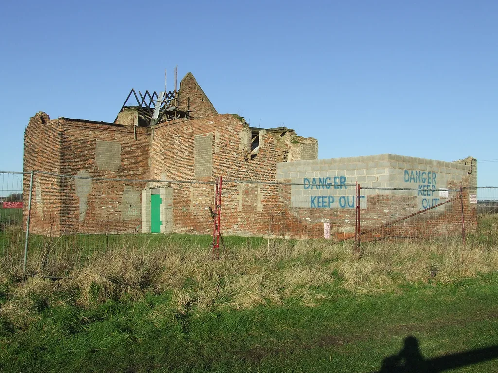
Baynard Castle — former moated castle built in the 12th and 13th centuries in the village of Cottingham, East Riding of Yorkshire, England.

Wikimedia Commons contributors — see linked file page for photographer and licence licence

Plan your visit
- Typical visit
- 1.5 h–3 h
- Nearest railway station
- Cottingham · 1.0 km
- Family-friendly
- Limited wheelchair access
Getting there & planning your visit
To visit Baynard Castle, the nearest railway station is Cottingham, located 1 km away. The postcode for sat-nav is HU16 5PA. Entry is free, but accessibility is limited for wheelchair users.
About
Baynard Castle is a castle in the United Kingdom — fortified architecture from the medieval, Tudor, or Victorian-revival period. Heritage designation: scheduled monument. Wikidata describes it as: "former moated castle built in the 12th and 13th centuries in the village of Cottingham, East Riding of Yorkshire, England". Coordinates: 53.7829°, -0.4216°.
Photo gallery
360° view
Imagery © Mapillary contributors, CC BY-SA 4.0
Heritage listing
Baynard Castle was a moated castle built in the 12th and 13th centuries in the village of Cottingham, East Riding of Yorkshire, England. It was referred to by terms including the 'castle at Cottingham' or 'Stuteville's castle'; the term Baynard Castle is common in 19th-century references and later.
From the Historic England List Entry under OGL v3.
From the Wikipedia article
Baynard Castle was a moated castle built in the 12th and 13th centuries in the village of Cottingham, East Riding of Yorkshire, England. It was referred to by terms including the 'castle at Cottingham' or 'Stuteville's castle'; the term Baynard Castle is common in 19th-century references and later.
Excerpt from Wikipedia under CC BY-SA 4.0. See the source article linked in Sources below.
Background
History
References to a manor house at the castle site in Cottingham date to as early as the 1170s; The male line of the de Stutevilles ended in 1233, and the castle was acquired by the le Wake family. Edward I stayed at the castle during Christmas 1299. In 1327 a second licence to crenellate was issued to Thomas Wake, but by the time of his death in 1349 the manor house was said to have fallen into decay. After Thomas Wake's death ownership of the castle passed via his sister Margaret Wake to the Earles of Kent (and Barons Holand). In 1365 the manor began to be repaired and the construction of a gate was ordered.
Description
The castle earthworks were rectangular in shape, with a bank and ditch, enclosing approximately 11 acre, a second line of ditch fortifications protected the northern half of the castle. A keep is postulated to have been in the north-east corner, and the current (2012) entrance to the site in the south-east quadrant is thought to relate to the original entrance.
Visiting
The use of the term Baynard Castle is recorded as early as the 19th century. In addition to the Old Manor House, two other buildings are listed buildings on the castle site, a coach house and associated stable, and 'The White House', both two-storey brick buildings dating to the 18th century located on the path leading to the castle site.
Sourced from Wikipedia under CC BY-SA 4.0.
- Coordinates
- 53.7829, -0.4216
- District
- East Riding of Yorkshire
- Parish
- Cottingham
- Postcode
- HU16 5PA
- Parliamentary constituency
- Kingston upon Hull North and Cottingham
- Nearest railway station
- Cottingham — 1 km
- Official site
- thegreatbritainguide.com
Sources
- wikidata: Q4874645 (CC0)
- wikipedia: Baynard Castle, Cottingham (CC BY-SA 4.0)
- commons: Baynard Castle, Cottingham, OS map, 1910.jpg (CC BY-SA 4.0)
Other places nearby

Picture Playhouse
Theatres · 0.5 km

Cottingham
Towns & cities · 0.5 km

Cottingham Cemetery
Cemeteries · 0.6 km

Southwood Hall
Historic houses · 0.8 km

Cottingham railway station
Heritage railway stations · 1.0 km

Thwaite Hall Gardens
Gardens · 1.3 km

Cottingham Castle Tower
Follies · 1.9 km
Haltemprice Priory
Abbeys & priories · 2.0 km

Skidby Mill
Windmills · 2.1 km

Skidby
Villages · 2.7 km

Wyke College
Natural landmarks · 3.0 km

Papa's Fish and Chips
Restaurants · 3.2 km
Nearby
📷 3Theatres · Yorkshire & the Humber
Picture Playhouse
Picture Playhouse in England Yorkshire, United Kingdom.
📷 5Towns & cities · Yorkshire & the Humber
Cottingham
Cottingham — village and civil parish in the East Riding of Yorkshire, England.
📷 3Cemeteries · Yorkshire & the Humber
Cottingham Cemetery
Cottingham Cemetery is a cemetery in the United Kingdom.
📷 3Historic houses · Yorkshire & the Humber
Southwood Hall
Southwood Hall — house in Cottingham, East Riding of Yorkshire, England, UK.
📷 5Heritage railway stations · Yorkshire & the Humber
Cottingham railway station
Cottingham railway station — a Grade II*-listed railway station in england-yorkshire, United Kingdom.
📷 3Gardens · Yorkshire & the Humber
Thwaite Hall Gardens
Thwaite Hall Gardens — Grade II listed park and garden in Cottingham, East Riding of Yorkshire, England, UK.
Where to eat & stay near Baynard Castle
Places to stay
 📷 5
📷 5Campsites · Yorkshire & the Humber
Butt Farm Caravan and Camping site
Butt Farm Caravan and Camping site — a campsite in england yorkshire.
 📷 5
📷 5Caravan parks · Yorkshire & the Humber
Raywell Hall Country Lodge Park
Raywell Hall Country Lodge Park — a caravan park in england yorkshire.
 📷 5
📷 5Campsites · Yorkshire & the Humber
Raywell Park
Raywell Park — a campsite in england yorkshire.
 📷 5
📷 5 📷 7
📷 7Hotels · Yorkshire & the Humber
DoubleTree by Hilton Hull
DoubleTree by Hilton Hull — a hotel in england yorkshire. 4-star. Brand: DoubleTree.
 📷 7
📷 7Hotels · Yorkshire & the Humber
The Beverley Arms
The Beverley Arms — a hotel in england yorkshire.
Places to eat & drink
📷 5Restaurants · Yorkshire & the Humber
Papa's Fish and Chips
Papa's Fish and Chips — a restaurant in england yorkshire. Cuisine: fish;fish and chips;chips. Brand: Papa's.
 📷 7
📷 7Historic pubs · Yorkshire & the Humber
Haworth Arms Public House
Haworth Arms Public House in England Yorkshire, United Kingdom.
 📷 5
📷 5Historic pubs · Yorkshire & the Humber
St. George's Hotel
St. George's Hotel in England Yorkshire, United Kingdom.
 📷 5
📷 5Historic pubs · Yorkshire & the Humber
Monks Walk Public House
Monks Walk Public House in England Yorkshire, United Kingdom.
 📷 5
📷 5Historic pubs · Yorkshire & the Humber
Criterion Public House
Criterion Public House in England Yorkshire, United Kingdom.
 📷 7
📷 7Cafés · Yorkshire & the Humber
Straddles Coffee Shop
Straddles Coffee Shop — a café in england yorkshire.
More castles in this region
 📷 5
📷 5Castles · Yorkshire & the Humber
Ashton-under-Lyne
Ashton-under-Lyne, also known simply as Ashton, is a market town in Tameside, Greater Manchester, United Kingdom. The population was 48,604 at the 2021 census. Historically a part of Lancashire, it is
 📷 5
📷 5Castles · Yorkshire & the Humber
Audenshaw
Audenshaw is a town in Tameside, Greater Manchester, England, 4.9 miles (7.9 km) east of Manchester. Historically part of Lancashire, in 2011 it had a population of 11,419. The name derives from Aldwi
 📷 5
📷 5Castles · Yorkshire & the Humber
Bramhall
Bramhall is a large village in the Metropolitan Borough of Stockport, Greater Manchester, England. It was formerly a civil parish in Cheshire. At the 2021 census, the built-up area, as defined by the
 📷 5
📷 5Castles · Yorkshire & the Humber
Bredbury
Bredbury is a town in the Metropolitan Borough of Stockport, Greater Manchester, England; it lies 8 miles (12.9 km) south-east of Manchester, 2 miles (3.2 km) east of Stockport and 3 miles (4.8 km) so
Frequently asked questions
- Where is Baynard Castle?
- Baynard Castle is in Yorkshire, United Kingdom (postcode HU16 5PA), in the parish of Cottingham.
- What is Baynard Castle?
- Baynard Castle — former moated castle built in the 12th and 13th centuries in the village of Cottingham, East Riding of Yorkshire, England.
- How do I get to Baynard Castle?
- The nearest railway station is Cottingham, about 1.0 km away. Drivers can use postcode HU16 5PA.
- Is Baynard Castle a listed building?
- Baynard Castle is officially recognised as scheduled monument listed.
- Does Baynard Castle charge admission?
- Baynard Castle typically charges admission. Check the official site for current ticket prices and opening hours.
- How do I get to Baynard Castle?
- The nearest railway station is Cottingham, about 1.0 km away. Drivers can navigate to postcode HU16 5PA.