Towns & cities · North East England
Bardon Mill
Bardon Mill — village in Northumberland, England, UK.

Wikimedia Commons contributors — see linked file page for photographer and licence licence
Plan your visit
- Typical visit
- 3 h–6 h
- Nearest railway station
- Bardon Mill · 0.5 km
- Free entry
- Family-friendly
- Dog-friendly
About
Bardon Mill is a town, city, village or settlement in the United Kingdom. Recent population estimates put it at around 363 people. Wikidata describes it as: "village in Northumberland, England, UK". Coordinates: 54.9750°, -2.3370°.
Photo gallery
Protected designations
- Site of Special Scientific Interest: River Eden and Tributaries SSSI
Designations sourced from Natural England open data under OGL v3.
From the Wikipedia article
Bardon Mill is a small village in Northumberland, within the vicinity of the ancient Hadrian's Wall. It is located around 10+1⁄2 miles (17 kilometres) from Hexham, 26+1⁄2 mi (43 km) from Carlisle, and 32 mi (51 km) from Newcastle upon Tyne. Nearby landmarks include Allen Banks & Staward Gorge, Sycamore Gap, The Sill: National Landscape Discovery Centre and Vindolanda Roman Fort.
Excerpt from Wikipedia under CC BY-SA 4.0. See the source article linked in Sources below.
- Coordinates
- 54.9750, -2.3370
- District
- Northumberland
- Parish
- Bardon Mill
- Postcode
- NE47 7BH
- Parliamentary constituency
- Hexham
- Population
- 363
- Nearest railway station
- Bardon Mill — 0.5 km
Sources
- wikidata: Q1858460 (CC0)
- wikipedia: Bardon Mill (CC BY-SA 4.0)
- commons: Bardon Mill in 2007.jpg (CC BY-SA 4.0)
Other places nearby

Beltingham River Shingle
Wildlife reserves · 0.4 km

Millhouse Bridge
Historic bridges · 0.4 km
Northumberland Wildlife Trust nature reserve
Wildlife reserves · 0.5 km

Bardon Mill railway station
Heritage railway stations · 0.6 km

Hawthorn Cottage Industry
Natural landmarks · 0.6 km
Bardon Mill Village Green
Natural landmarks · 0.7 km
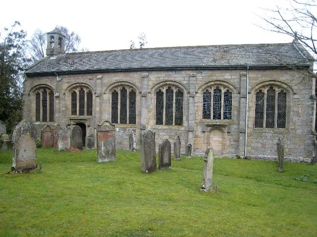
Church of St Cuthbert
Historic churches · 0.7 km

Ridley Railway Bridge
Historic bridges · 0.8 km

A69 road
Other places · 0.8 km

Thorngrafton
Villages · 0.9 km

Beltingham
Historic churches · 1.0 km

Redburn
Parks · 1.0 km
Bardon Mill is a village located in the Scottish Lowlands with a population of 363. Our guide lists nearby attractions within reach.
At a glance
- Population
- 363
- Constituency
- Hexham
- Top categories near here
Things to see in Bardon Mill
131 attractions within 12 km — showing the 24 most editorially-significant. Full guide: things to do in Bardon Mill →
 ★ Iconic📷 4
Archaeological sites · North East England
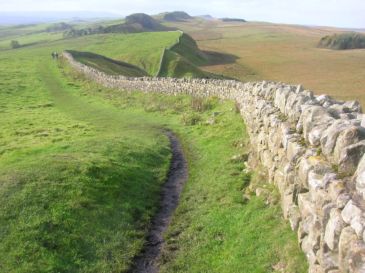
Hadrian's Wall
73-mile UNESCO World Heritage Roman frontier wall — Britain's most extensive Roman monument.
 📷 5
📷 5Archaeological sites · North East England
Milecastle 41
Milecastle 41 in England North East, United Kingdom.
 📷 4
📷 4National landscapes (AONB) · North East England
Allendale Town
Allendale Town in England North East, United Kingdom.
 📷 5
📷 5 📷 5
📷 5Archaeological sites · North East England
Once Brewed
Once Brewed in England North East, United Kingdom.
📷 4 📷 3
📷 3Heritage railway stations · North East England
Allendale railway station
Allendale railway station in England North East, United Kingdom.
📷 4Historic churches · North East England
Beltingham
Beltingham in England North East, United Kingdom.
 📷 4
📷 4Other places · North East England
Knag Burn Gateway
Knag Burn Gateway in England North East, United Kingdom.
 📷 3
📷 3Farms (open to visitors) · North East England
Milecastle 38
Milecastle 38 in England North East, United Kingdom.
 📷 4
📷 4 📷 3
📷 3Archaeological sites · North East England
Milecastle 37
Milecastle 37 in England North East, United Kingdom.
 📷 3
📷 3Archaeological sites · North East England
Milecastle 40
Milecastle 40 in England North East, United Kingdom.
 📷 3
📷 3Archaeological sites · North East England
Milecastle 36
Milecastle 36 in England North East, United Kingdom.
 📷 4
📷 4Historic bridges · North East England
Ridley Bridge
Ridley Bridge in England North East, United Kingdom.
📷 4Historic bridges · North East England
Ridley Railway Bridge
Ridley Railway Bridge in England North East, United Kingdom.
 📷 3
📷 3Historic bridges · North East England
Lipwood Railway Bridge
Lipwood Railway Bridge in England North East, United Kingdom.
📷 4Historic bridges · North East England
Millhouse Bridge
Millhouse Bridge in England North East, United Kingdom.
📷 3Wildlife reserves · North East England
Beltingham River Shingle
Beltingham River Shingle in England North East, United Kingdom.
 📷 5
📷 5Natural landmarks · North East England
Sycamore Gap Tree
Sycamore Gap Tree in England North East, United Kingdom.
 📷 4
📷 4Wildlife reserves · North East England
Muckle Moss
Muckle Moss in England North East, United Kingdom.
 📷 3📷 4
Heritage railway stations · North East England
Bardon Mill railway station
Bardon Mill railway station in England North East, United Kingdom.
 📷 4
📷 4Nearby
📷 3Wildlife reserves · North East England
Beltingham River Shingle
Beltingham River Shingle in England North East, United Kingdom.
📷 4Historic bridges · North East England
Millhouse Bridge
Millhouse Bridge in England North East, United Kingdom.
📷 3Wildlife reserves · North East England
Northumberland Wildlife Trust nature reserve
Northumberland Wildlife Trust nature reserve — a wildlife reserve in scotland-lowlands, United Kingdom.
📷 4Heritage railway stations · North East England
Bardon Mill railway station
Bardon Mill railway station in England North East, United Kingdom.
📷 3Natural landmarks · North East England
Hawthorn Cottage Industry
Hawthorn Cottage Industry — a other in scotland-lowlands, United Kingdom.
📷 3Natural landmarks · North East England
Bardon Mill Village Green
Bardon Mill Village Green — a other in scotland-lowlands, United Kingdom.
Where to eat & stay near Bardon Mill
Places to stay
 📷 5
📷 5 📷 5
📷 5Campsites · North East England
Winshields Farm Campsite
Winshields Farm Campsite — a campsite in scotland lowlands.
 📷 5
📷 5Caravan parks · North East England
Poplars Riverside Caravan Park
Poplars Riverside Caravan Park — a caravan park in scotland lowlands.
 📷 5
📷 5Campsites · North East England
Hadrian's Wall Campsite
Hadrian's Wall Campsite — a campsite in scotland lowlands.
 📷 5
📷 5B&Bs · North East England
Old Repeater Station
Old Repeater Station — a bed-and-breakfast in scotland lowlands.
 📷 5
📷 5Caravan parks · North East England
Seldom Seen Caravan Park
Seldom Seen Caravan Park — a caravan park in scotland lowlands.
Places to eat & drink
 📷 7
📷 7Historic pubs · North East England
Anchor Hotel
Anchor Hotel in Scotland Lowlands, United Kingdom.
 📷 5
📷 5 📷 5
📷 5 📷 6
📷 6 📷 5
📷 5Historic pubs · North East England
Travellers' Rest Inn
Travellers' Rest Inn in Scotland Lowlands, United Kingdom.
 📷 7
📷 7Historic pubs · North East England
The Vicars Pele
The Vicars Pele in Scotland Lowlands, United Kingdom.
More towns in this region
 Flagship📷 3
Towns & cities · North East England
Newby
Newby — village and civil parish in Hambleton, North Yorkshire, England, UK.
 📷 5
📷 5Towns & cities · North East England
Archdeacon Newton
Archdeacon Newton — village and civil parish in County Durham, England, UK.
 📷 3
📷 3Towns & cities · North East England
Boosbeck
Boosbeck — village in North Yorkshire, England, UK.
 📷 3
📷 3Frequently asked questions
- Where is Bardon Mill?
- Bardon Mill is in the Scottish Lowlands, United Kingdom (postcode NE47 7BH), in the parish of Bardon Mill.
- What is Bardon Mill?
- Bardon Mill — village in Northumberland, England, UK.
- How do I get to Bardon Mill?
- The nearest railway station is Bardon Mill, about 0.5 km away. Drivers can use postcode NE47 7BH.
- Is Bardon Mill a protected site?
- Yes — Bardon Mill is part of the River Eden and Tributaries SSSI Site of Special Scientific Interest.
- Is Bardon Mill free to visit?
- Yes, Bardon Mill is free to enter.
- How do I get to Bardon Mill?
- The nearest railway station is Bardon Mill, about 0.5 km away. Drivers can navigate to postcode NE47 7BH.