Country parks · North West England
Apedale Community Country Park
In or near Chesterton, Staffordshire.
Apedale Community Country Park is a 454-acre (184 ha) country park in the borough of Newcastle-under-Lyme, Staffordshire, England. The park is unusual for the area as it was previously an opencast min

Richard Styles — CC BY-SA 2.0 via Wikimedia Commons licence
Plan your visit
- Typical visit
- 1.5 h–3 h
- Nearest railway station
- Silverdale · 0.3 km
- Free entry
- Family-friendly
- Dog-friendly
Getting there & planning your visit
Apedale Community Country Park is located in Newcastle-under-Lyme, Staffordshire, with the postcode ST5 6BJ. The nearest railway station is Silverdale, which is 0.3 km away. Entry to the park is free.
About
Apedale Community Country Park is a 454-acre (184 ha) country park in the borough of Newcastle-under-Lyme, Staffordshire, England. The park is unusual for the area as it was previously an opencast mine. The area has a long history of mining, with the nearby former collieries at Silverdale and Holditch also having been redeveloped for other uses. The shallow mine at Holditch was redeveloped into a business park and an industrial estate, which led to significant capital gains for Staffordshire County Council. The amelioration of the park was part paid for out of these receipts. Within the park is the Apedale Heritage Centre. The adjoining Moseley Railway Trust is currently running the first phase of the 2 ft (610 mm) narrow gauge Apedale Valley Light Railway extending further into the parkland. There is a series of tracks, waymarked routes and self-guided trails. The country park is also the home of Newcastle Countryside Project and is bordered by the communities of Silverdale, Chesterton, Knutton and Cross Heath.
Photo gallery
Official information
Apedale Community Country Park offers a variety of attractions including mine tours, a museum, and a light railway. Visitors can explore the natural beauty of the country park and engage in educational activities.
From the Wikipedia article
Apedale Community Country Park is a 454-acre (184 ha) country park in the borough of Newcastle-under-Lyme, Staffordshire, England. The park is unusual for the area as it was previously an opencast mine. The area has a long history of mining, with the nearby former collieries at Silverdale and Holditch also having been redeveloped for other uses. The shallow mine at Holditch was redeveloped into a business park and an industrial estate, which led to significant capital gains for Staffordshire County Council. The amelioration of the park was part paid for out of these receipts. Within the park is the Apedale Heritage Centre. The adjoining Moseley Railway Trust is currently running the first phase of the 2 ft (610 mm) narrow gauge Apedale Valley Light Railway extending further into the parkland. There is a series of tracks, waymarked routes and self-guided trails. The country park is also the home of Newcastle Countryside Project and is bordered by the communities of Silverdale, Chesterton, Knutton and Cross Heath.
Excerpt from Wikipedia under CC BY-SA 4.0. See the source article linked in Sources below.
- Coordinates
- 53.0323, -2.2709
- County
- Staffordshire
- District
- Newcastle-under-Lyme
- Parish
- Newcastle-under-Lyme, unparished area
- Postcode
- ST5 6BJ
- Parliamentary constituency
- Newcastle-under-Lyme
- Nearest railway station
- Silverdale — 0.3 km
- Official site
- www.apedale.co.uk
Sources
- wikipedia: Apedale Community Country Park (CC BY-SA 4.0)
Other places nearby

Apedale Winding Wheel
Viewpoints · 0.2 km

Apedale Heritage Centre
Museums · 0.4 km

Watermills Chimney
Memorials & monuments · 0.5 km

Apedale Community Country Park Visitor Centre
Natural landmarks · 0.7 km

Black Bank
Mountains & hills · 0.8 km

Alsagers Bank
Mountains & hills · 1.3 km
Alsagers Bank
Mountains & hills · 1.4 km

Chesterton War Memorial
Memorials & monuments · 1.6 km

Alsagers Bank War Memorial
Memorials & monuments · 1.7 km
Chesterton, Staffordshire
Towns & cities · 1.7 km

Silverdale
Towns & cities · 1.8 km

Silverdale
Villages · 1.9 km
Nearby
📷 3Viewpoints · West Midlands
Apedale Winding Wheel
Apedale Winding Wheel is a viewpoint in the United Kingdom.
📷 3Museums · West Midlands
Apedale Heritage Centre
Apedale Heritage Centre — a museum in england-west-midlands, United Kingdom.
📷 3Memorials & monuments · West Midlands
Watermills Chimney
Watermills Chimney is a memorial in the United Kingdom.
📷 3Natural landmarks · West Midlands
Apedale Community Country Park Visitor Centre
Apedale Community Country Park Visitor Centre — a natural landmark in england-west-midlands, United Kingdom.
📷 5Mountains & hills · West Midlands
Black Bank
Black Bank — mountain in england west midlands. Elevation: 222 m.
📷 5Mountains & hills · West Midlands
Alsagers Bank
Alsagers Bank — a hill or mountain in england west midlands.
Where to eat & stay near Apedale Community Country Park
Places to stay
 📷 5
📷 5Hotels · West Midlands
Courtyard by Marriott
Courtyard by Marriott — a hotel in england west midlands. 4-star. Brand: Marriott.
 📷 5
📷 5Hotels · West Midlands
Travelodge
Travelodge — a hotel in england west midlands.
 📷 5
📷 5Hotels · West Midlands
Borough Arms Hotel
Borough Arms Hotel — a hotel in england west midlands.
 📷 5
📷 5Hotels · West Midlands
Hilton Garden Inn Stoke on Trent
Hilton Garden Inn Stoke on Trent — a hotel in england west midlands. 4-star. Brand: Hilton Garden Inn.
 📷 5
📷 5Hotels · West Midlands
North Stafford Hotel
North Stafford Hotel — a hotel in england west midlands.
 📷 5
📷 5Caravan parks · West Midlands
Stableford Caravan Park
Stableford Caravan Park — a caravan park in england west midlands.
Places to eat & drink
 📷 5
📷 5Historic pubs · North West England
The Wine Vaults Public House
The Wine Vaults Public House in England North West, United Kingdom.
 📷 5
📷 5 📷 3
📷 3Historic pubs · West Midlands
Duke William
Duke William — Historic pub — listed building or notable heritage status.
 📷 5
📷 5Historic pubs · West Midlands
Leopard Public House
Leopard Public House in England North West, United Kingdom.
 📷 5
📷 5Historic pubs · West Midlands
The Old Greyhound Public House
The Old Greyhound Public House in England North West, United Kingdom.
 📷 5
📷 5Historic pubs · West Midlands
The Vine Public House
The Vine Public House in England North West, United Kingdom.
More places in this region
 Flagship📷 3
Country parks · North West England
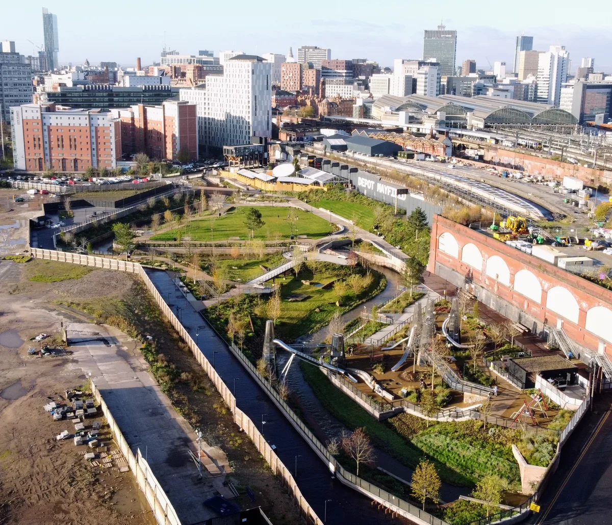
Mayfield Park
Mayfield Park — park in Manchester, United Kingdom.
 📷 3
📷 3Country parks · North West England
Congleton Park
Congleton Park — park in Congleton, Cheshire, England, UK.
 📷 3
📷 3Country parks · North West England
Didsbury Park
Didsbury Park — park in Didsbury, Manchester, England, UK.
 📷 3
📷 3Country parks · North West England
Ladybarn Park
Ladybarn Park — urban park in Withington, Manchester, England, United Kingdom.
Frequently asked questions
- Where is Apedale Community Country Park?
- Apedale Community Country Park is in Staffordshire, North-West England, United Kingdom (postcode ST5 6BJ), in the parish of Newcastle-under-Lyme, unparished area.
- What is Apedale Community Country Park?
- Apedale Community Country Park is a 454-acre (184 ha) country park in the borough of Newcastle-under-Lyme, Staffordshire, England. The park is unusual for the area as it was previously an opencast min
- How do I get to Apedale Community Country Park?
- The nearest railway station is Silverdale, about 0.3 km away. Drivers can use postcode ST5 6BJ.
- Is Apedale Community Country Park free to visit?
- Yes, Apedale Community Country Park is free to enter.
- How do I get to Apedale Community Country Park?
- The nearest railway station is Silverdale, about 0.3 km away. Drivers can navigate to postcode ST5 6BJ.