Natural landmarks · North West England
Angle Tarn
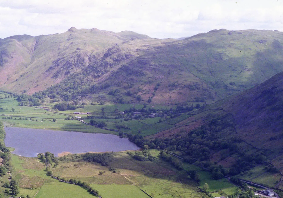
In or near Patterdale.
Angle Tarn — lake near Patterdale, Cumbria, England, United Kingdom.

Wikimedia Commons contributors — see linked file page for photographer and licence licence
Plan your visit
- Typical visit
- 1 h–2 h
- Free entry
- Dog-friendly
About
Angle Tarn is a named natural landmark in the United Kingdom. Wikidata describes it as: "lake near Patterdale, Cumbria, England, United Kingdom". Coordinates: 54.5197°, -2.9006°.
Photo gallery
Protected designations
- Site of Special Scientific Interest: River Eden and Tributaries SSSI
Designations sourced from Natural England open data under OGL v3.
From the Wikipedia article
Angle Tarn is a tarn in Cumbria, England, within the Lake District National Park, about a mile north-east of Hartsop. Located at an altitude of 479 m (1,572 ft), the lake has an area of 5.9 hectares (15 acres), measures 385 by 260 m (1,263 by 853 ft), with a maximum depth of 9 m (30 ft). The lake is very distinctive in that it resembles a fish hook in shape. It contains two rocky islets and a small broken peninsula. It is located on the Angletarn Pikes, which are named after it. This should not be confused with Angle Tarn (Langstrath), a smaller lake with the same name about 18.5 km to the northeast near Bowfell, also within the Lake District National Park. Angle Tarn is a popular spot for overnight wild camping, especially on weekends and in the summer months. The tarn has been described by Alfred Wainwright as among the best of Lakeland tarns.
Excerpt from Wikipedia under CC BY-SA 4.0. See the source article linked in Sources below.
- Coordinates
- 54.5197, -2.9006
- District
- Westmorland and Furness
- Parish
- Patterdale
- Postcode
- CA11 0NY
- Parliamentary constituency
- Westmorland and Lonsdale
Sources
- wikidata: Q4763352 (CC0)
- wikipedia: Angle Tarn (Patterdale) (CC BY-SA 4.0)
- commons: Angle Tarn.JPG (CC BY-SA 4.0)
Other places nearby

Buck Crag
Mountains & hills · 0.5 km
Brock Crags
Natural landmarks · 0.5 km

Brock Crags (summit)
Mountains & hills · 0.5 km

Brock Crags (Wainwright)
Mountains & hills · 0.6 km

Angletarn Pikes South Top
Mountains & hills · 0.6 km

Heck Crag
Mountains & hills · 0.8 km

Angletarn Pikes
Mountains & hills · 0.8 km

Angletarn Pikes
Natural landmarks · 0.8 km

Dubhow Copper Mine
Viewpoints · 1.0 km

Stony Rigg
Mountains & hills · 1.1 km

Hartsop Fold Holiday Lodges
Caravan parks · 1.3 km

Hartsop Fold
Caravan parks · 1.3 km
Nearby
📷 5Mountains & hills · North West England
Buck Crag
Buck Crag — mountain in england north east. Elevation: 569.5 m.
📷 3📷 5Mountains & hills · North West England
Brock Crags (summit)
Brock Crags (summit) — mountain in england north east. Elevation: 564.3 m.
📷 3Mountains & hills · North West England
Brock Crags (Wainwright)
Brock Crags (Wainwright) — Named summit at 561.2 m.
📷 3Mountains & hills · North West England
Angletarn Pikes South Top
Angletarn Pikes South Top — Named summit at 563.6 m.
📷 5Mountains & hills · North West England
Heck Crag
Heck Crag — mountain in england north east. Elevation: 560 m.
Where to eat & stay near Angle Tarn
Places to stay
📷 5Caravan parks · North West England
Hartsop Fold Holiday Lodges
Hartsop Fold Holiday Lodges — a caravan park in england north east.
📷 5 📷 5
📷 5B&Bs · North West England
Greenbank Farm Bed and Breakfast
Greenbank Farm Bed and Breakfast — a bed-and-breakfast in england north east.
 📷 5
📷 5B&Bs · North West England
Deepdale Hall B&B
Deepdale Hall B&B — a bed-and-breakfast in england north east.
 📷 5
📷 5Campsites · North West England
Patterdale Youth Hostel camp site
Patterdale Youth Hostel camp site — a campsite in england north east.
📷 5Hostels · North West England
Patterdale Youth Hostel
Patterdale Youth Hostel — a hostel in england north east. Brand: Youth Hostels Association.
Places to eat & drink
 📷 7
📷 7Historic pubs · North West England
The Travellers Rest
The Travellers Rest in England North West, United Kingdom.
 📷 5
📷 5Historic pubs · North West England
Golden Rule Hotel
Golden Rule Hotel in England North West, United Kingdom.
 📷 4
📷 4Restaurants · North West England
Holbeck Ghyll
Holbeck Ghyll is a restaurant located in Windermere, Cumbria, England. "The late 19th century building was once Lord Lonsdale's hunting lodge and only became a hotel in the 1970s. It won a Michelin st
 📷 5
📷 5Restaurants · North West England
Holbeck Ghyll Restaurant
Holbeck Ghyll Restaurant — a restaurant in england north west.
📷 5Historic pubs · North West England
Holbeck Ghyll
Holbeck Ghyll in England North West, United Kingdom.
 📷 5
📷 5Historic pubs · North West England
Horse And Farrier Inn And Stables
Horse And Farrier Inn And Stables in Scotland Lowlands, United Kingdom.
More natural landmarks in this region
 📷 3
📷 3Natural landmarks · North West England
Statue of Oliver Cromwell
Statue of Oliver Cromwell — Public artwork (statue).
 📷 3
📷 3Natural landmarks · North West England
Dagfields Craft Centre
Dagfields Craft Centre — a other in england-west-midlands, United Kingdom.
 📷 3
📷 3Natural landmarks · North West England
Weaver Valley Cruises
Weaver Valley Cruises — a other in england-west-midlands, United Kingdom.
 📷 3
📷 3Natural landmarks · North West England
Golden Gates
Golden Gates — a other in england-west-midlands, United Kingdom.
Frequently asked questions
- Where is Angle Tarn?
- Angle Tarn is in North-East England, United Kingdom (postcode CA11 0NY), in the parish of Patterdale.
- What is Angle Tarn?
- Angle Tarn — lake near Patterdale, Cumbria, England, United Kingdom.
- How do I get to Angle Tarn?
- Drivers can use postcode CA11 0NY.
- Is Angle Tarn a protected site?
- Yes — Angle Tarn is part of the River Eden and Tributaries SSSI Site of Special Scientific Interest.
- Is Angle Tarn free to visit?
- Yes, Angle Tarn is free to enter.
- How do I get to Angle Tarn?
- Drivers can navigate to postcode CA11 0NY. It sits within the Westmorland and Lonsdale parliamentary constituency.