
Historic churches · East Midlands
Ancaster, Lincolnshire
In or near Byards Leap.
Ancaster is a village and civil parish in the South Kesteven district of Lincolnshire, England, on the site of a Roman town. The population of the civil parish was 1,317 at the 2001 census, increasing

Chris — CC BY-SA 2.0 via Wikimedia Commons licence
_-_geograph.org.uk_-_6578455.jpg)
Plan your visit
- Typical visit
- 30 min–1 h
- Nearest railway station
- Ancaster · 2.0 km
- Free entry
Getting there & planning your visit
To visit Ancaster in Lincolnshire, the nearest railway station is Ancaster, located 2 km away. The postcode for your sat-nav is NG32 3PY. Entry to the church is free.
About
Ancaster is a village and civil parish in the South Kesteven district of Lincolnshire, England, on the site of a Roman town. The population of the civil parish was 1,317 at the 2001 census, increasing to 1,647 at the 2011 census. The civil parish includes the settlements of Sudbrook and West Willoughby. The village is related to the titles of Duke of Ancaster and Kesteven and Earl of Ancaster, both of which are now extinct.
Photo gallery
Protected designations
- Site of Special Scientific Interest: Copper Hill SSSI
Designations sourced from Natural England open data under OGL v3.
From the Wikipedia article
Ancaster is a village and civil parish in the South Kesteven district of Lincolnshire, England, on the site of a Roman town. The population of the civil parish was 1,317 at the 2001 census, increasing to 1,647 at the 2011 census. The civil parish includes the settlements of Sudbrook and West Willoughby. The village is related to the titles of Duke of Ancaster and Kesteven and Earl of Ancaster, both of which are now extinct.
Excerpt from Wikipedia under CC BY-SA 4.0. See the source article linked in Sources below.
Background
History
Ancaster was a Roman town at the junction of the Roman roads of Ermine Street and King Street. During the Romano-British period, the Romans built a roadside settlement on the site of a "Corieltauvi" settlement. It was traditionally thought to have been named "Causennis," although that is now believed to be Saltersford near Grantham. Ancaster lies on Ermine Street, the major Roman road heading north from London. To the north-west of Ancaster is a Roman marching camp, and some 4th-century Roman earthworks are still visible. Excavations have found a cemetery containing more than 250 Roman burials, including 11 stone sarcophagi. In the later years of Roman occupation, a large stone wall with…
Sourced from Wikipedia under CC BY-SA 4.0.
- Coordinates
- 52.9700, -0.5400
- County
- Lincolnshire
- District
- South Kesteven
- Parish
- Ancaster
- Postcode
- NG32 3PY
- Parliamentary constituency
- Grantham and Bourne
- Nearest railway station
- Ancaster — 2 km
- Official site
- www.neighbourhood.statistics.gov.uk
Sources
- wikipedia: Ancaster, Lincolnshire (CC BY-SA 4.0)
Other places nearby

Copper Hill
Mountains & hills · 0.5 km

English Electric Canberra B(I)8
Museums · 0.7 km

Ancaster
Castles · 1.1 km

Ancaster Camp
Archaeological sites · 1.2 km
Ancaster Roman town
Vineyards · 1.2 km
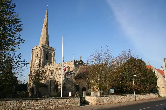
St Martin's Church, Ancaster
Historic churches · 1.2 km
.jpg?width=1200)
Ancaster Hall
Historic houses · 1.2 km

Ancaster village cross
Memorials & monuments · 1.5 km

Woodland Waters
Campsites · 1.6 km

West Willoughby War Memorial
Memorials & monuments · 1.8 km

Roman marching camp
Archaeological sites · 2.1 km

Kelby
Villages · 2.5 km
Nearby
📷 5Mountains & hills · East Midlands
Copper Hill
Copper Hill — mountain in england east midlands. Elevation: 105 m.
📷 5Museums · East Midlands
English Electric Canberra B(I)8
English Electric Canberra B(I)8 — a museum in england-east-midlands, United Kingdom.
📷 5📷 3Archaeological sites · East Midlands
Ancaster Camp
Ancaster Camp — a archaeological in england-east-midlands, United Kingdom.
📷 5Vineyards · East Midlands
Ancaster Roman town
Ancaster Roman town — a UK vineyard in england east midlands, producing English or Welsh wine from cool-climate grape varieties.
📷 3Historic churches · East Midlands
St Martin's Church, Ancaster
St Martin's Church, Ancaster — church in Ancaster, Lincolnshire, England, UK.
Where to eat & stay near Ancaster, Lincolnshire
Places to stay
📷 5Campsites · East Midlands
Woodland Waters
Woodland Waters — a campsite in england east midlands.
 📷 5
📷 5Caravan parks · East Midlands
Wagtail Country Park
Wagtail Country Park — a caravan park in england east midlands.
 📷 5
📷 5 📷 5
📷 5Campsites · East Midlands
Oakhill Leisure Ltd
Oakhill Leisure Ltd — a campsite in england east midlands.
 📷 5
📷 5Caravan parks · East Midlands
Skybarn Farm CAMC CL
Skybarn Farm CAMC CL — a caravan park in england east midlands.
 📷 3
📷 3Caravan parks · East Midlands
Cathedral View Holiday Park
Cathedral View Holiday Park — a caravan park in england east midlands.
Places to eat & drink
 📷 5
📷 5Historic pubs · East Midlands
Houblon Arms Public House
Houblon Arms Public House in England East, United Kingdom.
 📷 5
📷 5Historic pubs · East Midlands
Brownlow Arms Public House
Brownlow Arms Public House in England East, United Kingdom.
 📷 5
📷 5Historic pubs · East Midlands
The Waggon And Horses
The Waggon And Horses in England East, United Kingdom.
 📷 5
📷 5 📷 7
📷 7 📷 6
📷 6More places in this region
 📷 5
📷 5Historic churches · East Midlands
All Saints' Church, Stamford
All Saints' Church, Stamford — church in Stamford, Lincolnshire, England, UK.
 📷 5
📷 5Historic churches · East Midlands
Church of All Saints
Church of All Saints — church in Little Casterton, Rutland, United Kingdom.
 📷 5
📷 5Historic churches · East Midlands
Church of All Saints
Church of All Saints — church in Fenland, UK.
 📷 5
📷 5Historic churches · East Midlands
Church of St Leonard
Church of St Leonard — church in Fenland, UK.
Frequently asked questions
- Where is Ancaster, Lincolnshire?
- Ancaster, Lincolnshire is in Lincolnshire, the East Midlands, United Kingdom (postcode NG32 3PY), in the parish of Ancaster.
- What is Ancaster, Lincolnshire?
- Ancaster is a village and civil parish in the South Kesteven district of Lincolnshire, England, on the site of a Roman town. The population of the civil parish was 1,317 at the 2001 census, increasing
- How do I get to Ancaster, Lincolnshire?
- The nearest railway station is Ancaster, about 2.0 km away. Drivers can use postcode NG32 3PY.
- Is Ancaster, Lincolnshire a protected site?
- Yes — Ancaster, Lincolnshire is part of the Copper Hill SSSI Site of Special Scientific Interest.
- Is Ancaster, Lincolnshire free to visit?
- Yes, Ancaster, Lincolnshire is free to enter.
- How do I get to Ancaster, Lincolnshire?
- The nearest railway station is Ancaster, about 2.0 km away. Drivers can navigate to postcode NG32 3PY.