Mountains & hills · Scottish Highlands
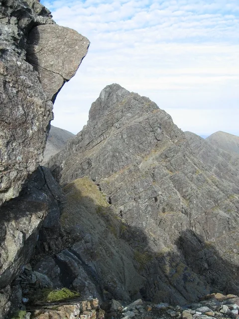
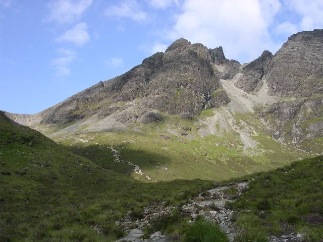
An Stac
An Stac — mountain in scotland highlands. Elevation: 528 m.

Ian Taylor — CC BY-SA 2.0 via Wikimedia Commons licence
Plan your visit
- Typical visit
- 3 h–8 h
- Best time of year
- Late spring – early autumn (May–Oct)
About
An Stac is a mountain located in scotland highlands. Elevation: 528 m. A named British peak recorded in OpenStreetMap. Peaks are typically named on Ordnance Survey 1:50k mapping.
Photo gallery
Place summary
An Stac is a prominent mountain located in the Scottish Highlands. It is noted for its rugged terrain and striking geological features. Visitors can expect a challenging ascent with rewarding views of the surrounding landscape. The area is popular among hikers and climbers seeking outdoor adventure in a remote setting.
AI-generated from the structured facts on this page (operator, designation, listing, era). Not a substitute for visiting.
- Coordinates
- 57.2154, -6.0730
Sources
- osm: n9933458089 (ODbL)
Other places nearby
Loading nearby places…
Nearby
📷 5Mountains & hills · Scottish Highlands
An Stac
An Stac — a hill or mountain in scotland highlands.
 📷 3
📷 3Natural landmarks · Scottish Highlands
Clach Glas
Clach Glas — mountain on the Isle of Skye, in Highland, Scotland, UK.
 📷 4
📷 4Mountains & hills · Scottish Highlands
Blà Bheinn
Blà Bheinn — Named summit at 928 m.
 📷 4
📷 4Natural landmarks · Scottish Highlands
Blà Bheinn
Blà Bheinn — 929m high mountain on the Isle of Skye, in Highland, Scotland, UK.
 📷 5
📷 5Mountains & hills · Scottish Highlands
Blabheinn
Blabheinn — a hill or mountain in scotland highlands.
 📷 5
📷 5Mountains & hills · Scottish Highlands
Sgurr nan Each
Sgurr nan Each — a hill or mountain in scotland highlands.
Where to eat & stay near An Stac
Places to stay
 📷 5
📷 5Campsites · Scottish Highlands
Camping Skye
Camping Skye — a campsite in scotland highlands.
 📷 5
📷 5Hostels · Scottish Highlands
Sligachan Bunkhouse
Sligachan Bunkhouse — a hostel in scotland highlands.
 📷 5
📷 5Hostels · Scottish Highlands
Broadford Backpackers Hostel
Broadford Backpackers Hostel — a hostel in scotland highlands.
 📷 5
📷 5Hostels · Scottish Highlands
Broadford Youth Hostel
Broadford Youth Hostel — a hostel in scotland highlands. Brand: Hostelling Scotland.
 📷 5
📷 5Campsites · Scottish Highlands
Sligachan Campsite
Sligachan Campsite — a campsite in scotland highlands.
 📷 5
📷 5Hostels · Scottish Highlands
Skye Basecamp
Skye Basecamp — a hostel in scotland highlands.
More mountains in this region
 📷 3
📷 3Mountains & hills · Scottish Highlands
A' Bhuidheanach Bheag
A' Bhuidheanach Bheag — Named summit at 936 m.
 📷 3
📷 3Mountains & hills · Scottish Highlands
A' Chailleach
A' Chailleach — Named summit at 997 m.
 📷 3
📷 3Mountains & hills · Scottish Highlands
A' Chailleach
A' Chailleach — Named summit at 930 m.
 📷 3
📷 3Mountains & hills · Scottish Highlands
A' Chaoirnich
A' Chaoirnich — Named summit at 875 m.
Frequently asked questions
- Where is An Stac?
- An Stac is in the Scottish Highlands, United Kingdom.
- What is An Stac?
- An Stac — mountain in scotland highlands. Elevation: 528 m.
- How do I get to An Stac?
- Its coordinates are 57.2154°, -6.0730°.