Piers · North Wales
Admiralty Pier (Including Sea Wall Between Salt Island Bridge and George Iv Arch), Salt Island
In or near Trearddur.
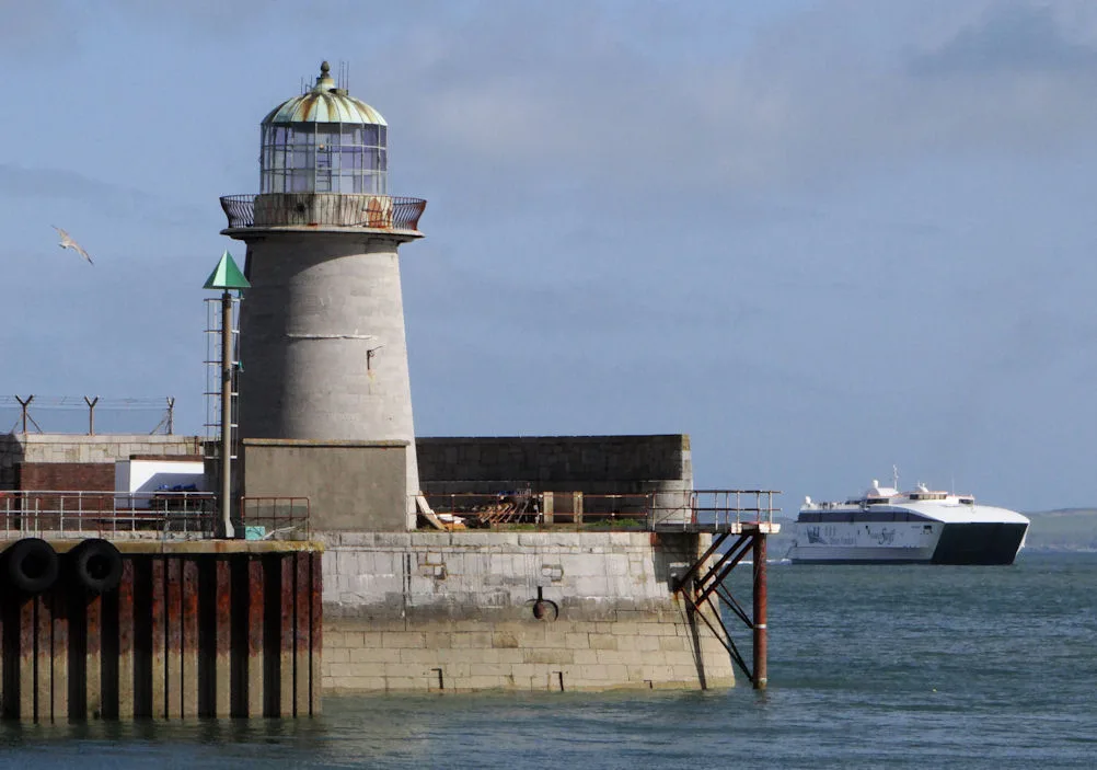
Admiralty Pier (Including Sea Wall Between Salt Island Bridge and George Iv Arch), Salt Island — Grade II listed building-listed pier in wales-north, United Kingdom.

Malcolm Neal — CC BY-SA 2.0 via Wikimedia Commons licence
Plan your visit
- Typical visit
- 30 min–1 h
- Best time of year
- Summer
- Nearest railway station
- Holyhead · 1.0 km
- Free entry
- Family-friendly
- Dog-friendly
- Limited wheelchair access
Getting there & planning your visit
To visit Admiralty Pier, you can reach it via Holyhead railway station, which is 1 km away. The postcode for sat-nav is LL65 1DR, and entry is free. Please note that wheelchair access is limited.
About
Admiralty Pier (Including Sea Wall Between Salt Island Bridge and George Iv Arch), Salt Island is a Grade II listed building-listed pier in wales-north, United Kingdom, registered on the Cadw register of listed buildings (Wales) (entry 14757). Listed status protects buildings and structures of special architectural or historic interest. See the linked Wikipedia article for further details.
Photo gallery
Heritage listing
Reason for designation: Listed as an integral part of this important harbour scheme designed by Rennie. Group value. History: In 1810 an Act of Parliament was passed which included much needed improvement to the harbour at Holyhead which had by that time become established as the principal port for communication with Ireland, in particular it was the station for the Post Office steam packets. This work involved the construction of the Admiralty Pier and lighthouse to the east of Salt Island and Harbour-Master’s Offices and Customs House, with later addition of the George IV Arch. Exterior: Stone pier, 1810-1821 by John Rennie Senior, engineer. Approximately 500m long (from Salt Island Bridge, including facing and consolidating walls on Salt Island). Large squared masonry blocks. Square projection to SE side; pier broadens at E end at lighthouse. Stone stairs down to water level on S side, and sloping revetted wall to seaward (N) side, above which is wall circa 2m high with walkway (metal handrail). Location: At NE end of Victoria Road, projecting E into harbour.
From Cadw under OGL v3.
Place summary
Admiralty Pier, located in Holyhead, North Wales, is a Grade II listed building. It includes the sea wall between Salt Island Bridge and George IV Arch, serving as a notable structure in the area.
AI-generated from the structured facts on this page (operator, designation, listing, era). Not a substitute for visiting.
- Coordinates
- 53.3143, -4.6224
- District
- Isle of Anglesey
- Parish
- Holyhead
- Postcode
- LL65 1DR
- Parliamentary constituency
- Ynys Môn
- Nearest railway station
- Holyhead — 1 km
Sources
- wikidata: Q29492577 (CC0)
Other places nearby

George IV Arch
Memorials & monuments · 0.2 km
Holyhead Mail Pier Lighthouse
Lighthouses · 0.2 km

Salt Island
Islands · 0.2 km

Port of Holyhead
Harbours & ports · 0.7 km

Caer Gybi Roman Fort
Forts · 0.7 km

Skinner Monument
Memorials & monuments · 0.7 km
Caer Gybi
Castles · 0.8 km

Eglwys y Bedd
Historic churches · 0.8 km

Holyhead Town Hall
Theatres · 0.8 km

Cybi Cinema
Theatres · 0.8 km
Newry Beach
Beaches · 0.8 km

Holyhead
Historic churches · 0.9 km
Nearby
📷 4Memorials & monuments · North Wales
George IV Arch
George IV Arch is a memorial in the United Kingdom.
📷 4Lighthouses · North Wales
Holyhead Mail Pier Lighthouse
Holyhead Mail Pier Lighthouse — lighthouse, Grade II listed building in Holyhead, Wales; at the E end of Admiralty Pier.
📷 5📷 3Harbours & ports · North Wales
Port of Holyhead
Port of Holyhead — commercial and ferry port in Anglesey, Wales, UK.
📷 3📷 5Memorials & monuments · North Wales
Skinner Monument
Skinner Monument — Grade II listed building-listed memorial in wales-north, United Kingdom.
Where to eat & stay near Admiralty Pier (Including Sea Wall Between Salt Island Bridge and George Iv Arch), Salt Island
Places to stay
 📷 5
📷 5Caravan parks · North Wales
Valley Of The Rocks Caravan Park
Valley Of The Rocks Caravan Park — a caravan park in wales north.
📷 5Campsites · North Wales
Valley Of The Rocks Campsite
Valley Of The Rocks Campsite — a campsite in wales north.
 📷 5
📷 5Caravan parks · North Wales
Trearddur Bay Country Park
Trearddur Bay Country Park — a caravan park in wales north.
 📷 5
📷 5Campsites · North Wales
Penrhyn Bay Caravan Park
Penrhyn Bay Caravan Park — a campsite in wales north.
 📷 5📷 5
Campsites · North Wales
Blackthorn Farm Campsite
Blackthorn Farm Campsite — a campsite in wales north.
Places to eat & drink
 📷 5
📷 5Restaurants · North Wales
Oyster Catcher
Oyster Catcher — a restaurant in wales north.
 📷 5
📷 5Historic pubs · North Wales
The Kings Head Hotel
The Kings Head Hotel in Wales North, United Kingdom.
 📷 5
📷 5Historic pubs · North Wales
The Bull Hotel, Llangefni
The Bull Hotel, Llangefni in Wales North, United Kingdom.
More piers in this region
.jpg?width=1200) 📷 5
📷 5 📷 3
📷 3Piers · North Wales
Colwyn Bay Pier
Colwyn Bay Pier is a pier in the United Kingdom.
 📷 3
📷 3Piers · North Wales
Llandudno Pier
Llandudno Pier is a pier in the United Kingdom.
 📷 3
📷 3Piers · North Wales
Pier Biwmares / Beaumaris Pier
Pier Biwmares / Beaumaris Pier is a pier in the United Kingdom.
Frequently asked questions
- Where is Admiralty Pier (Including Sea Wall Between Salt Island Bridge and George Iv Arch), Salt Island?
- Admiralty Pier (Including Sea Wall Between Salt Island Bridge and George Iv Arch), Salt Island is in North Wales, United Kingdom (postcode LL65 1DR), in the parish of Holyhead.
- What is Admiralty Pier (Including Sea Wall Between Salt Island Bridge and George Iv Arch), Salt Island?
- Admiralty Pier (Including Sea Wall Between Salt Island Bridge and George Iv Arch), Salt Island — Grade II listed building-listed pier in wales-north, United Kingdom.
- How do I get to Admiralty Pier (Including Sea Wall Between Salt Island Bridge and George Iv Arch), Salt Island?
- The nearest railway station is Holyhead, about 1.0 km away. Drivers can use postcode LL65 1DR.
- Is Admiralty Pier (Including Sea Wall Between Salt Island Bridge and George Iv Arch), Salt Island a listed building?
- Admiralty Pier (Including Sea Wall Between Salt Island Bridge and George Iv Arch), Salt Island is officially recognised as Grade II listed building listed.
- Is Admiralty Pier (Including Sea Wall Between Salt Island Bridge and George Iv Arch), Salt Island free to visit?
- Yes, Admiralty Pier (Including Sea Wall Between Salt Island Bridge and George Iv Arch), Salt Island is free to enter.
- How do I get to Admiralty Pier (Including Sea Wall Between Salt Island Bridge and George Iv Arch), Salt Island?
- The nearest railway station is Holyhead, about 1.0 km away. Drivers can navigate to postcode LL65 1DR.