Scottish Lowlands · Archaeological sites
Archaeological sites in Scottish Lowlands
504 archaeological sites to visit in Scottish Lowlands. Oldest in our list: Tibbers Castle (1250). Most are tudor stuart in date (1 of 504).
 📷 3
📷 3Hill forts · Scottish Lowlands
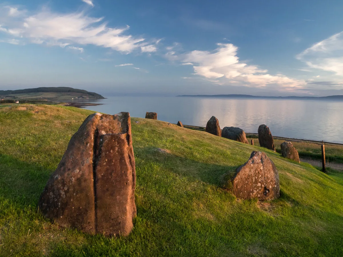
Auchagallon Stone Circle
Auchagallon Stone Circle — archaeological site in North Ayrshire, Scotland, UK.
 📷 5
📷 5Hill forts · Scottish Lowlands
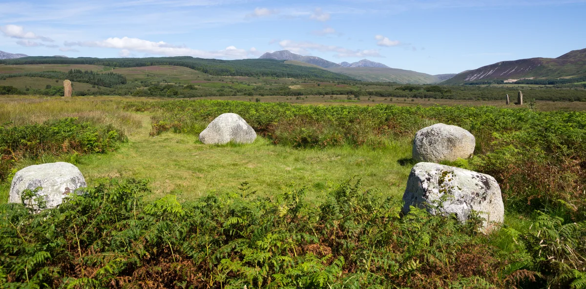
Machrie Moor Stone Circles
Machrie Moor Stone Circles — archaeological site in North Ayrshire, Scotland, UK.
 📷 3
📷 3Hill forts · Scottish Lowlands
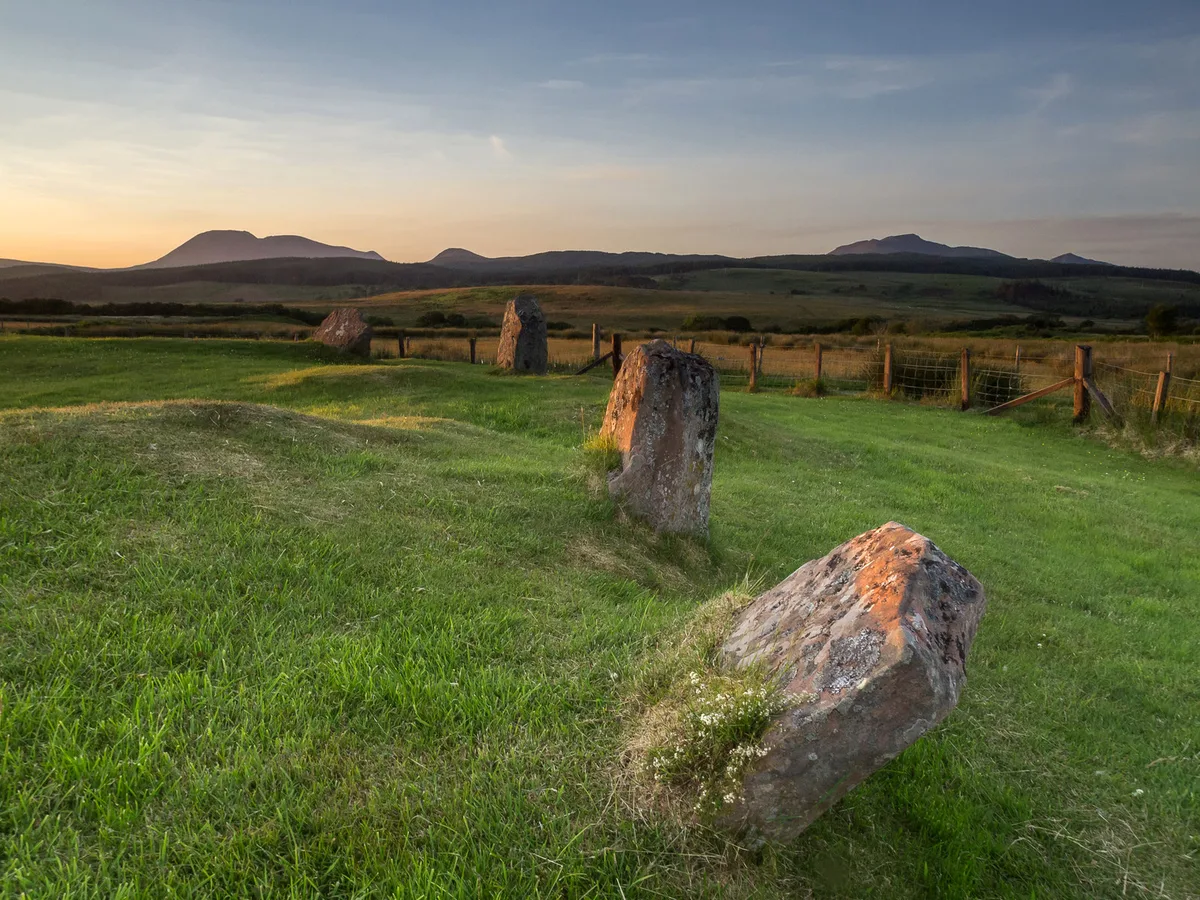
Moss Farm Road Stone Circle
Moss Farm Road Stone Circle — archaeological site in North Ayrshire, Scotland, UK.
 📷 3
📷 3Archaeological sites · Scottish Lowlands
Cup marked stone
Cup marked stone — a archaeological in scotland-highlands, United Kingdom.
 📷 3
📷 3Archaeological sites · Scottish Lowlands
'the Sailor's Grave' Cist
'the Sailor's Grave' Cist — a archaeological in scotland-highlands, United Kingdom.
 📷 3
📷 3Archaeological sites · Scottish Lowlands
Cup and Ring Marked Rock
Cup and Ring Marked Rock — a archaeological in scotland-highlands, United Kingdom.
 📷 3
📷 3Archaeological sites · Scottish Lowlands
Cup and ring marked stone
Cup and ring marked stone — a archaeological in scotland-highlands, United Kingdom.
 📷 3
📷 3Archaeological sites · Scottish Lowlands
Cup and ring marked stones
Cup and ring marked stones — a archaeological in scotland-highlands, United Kingdom.
 📷 3
📷 3Archaeological sites · Scottish Lowlands
Group of stones
Group of stones — a archaeological in scotland-highlands, United Kingdom.
 📷 3
📷 3Archaeological sites · Scottish Lowlands
Dunan Mòr
Dunan Mòr — a archaeological in scotland-highlands, United Kingdom.
 📷 3
📷 3Archaeological sites · Scottish Lowlands
Carragh Bhan
Carragh Bhan — a archaeological in scotland-highlands, United Kingdom.
 📷 3
📷 3Archaeological sites · Scottish Lowlands
Toft Colliery
Toft Colliery — a archaeological in scotland-highlands, United Kingdom.
 📷 3
📷 3Archaeological sites · Scottish Lowlands
Meallach's Grave
Meallach's Grave — a archaeological in scotland-highlands, United Kingdom.
 📷 5
📷 5Archaeological sites · Scottish Lowlands
Garvalt, dun site
Garvalt, dun site — a archaeological in scotland-highlands, United Kingdom.
 📷 5
📷 5Archaeological sites · Scottish Lowlands
An Dunan, dun site
An Dunan, dun site — a archaeological in scotland-highlands, United Kingdom.
 📷 3
📷 3Archaeological sites · Scottish Lowlands
Cladh Eilisteir
Cladh Eilisteir — a archaeological in scotland-highlands, United Kingdom.

Archaeological sites · Scottish Lowlands
Carn Daibhidh
Carn Daibhidh — a archaeological in scotland-highlands, United Kingdom.
 📷 3
📷 3Archaeological sites · Scottish Lowlands
Lossit, promontory fort
Lossit, promontory fort — a archaeological in scotland-highlands, United Kingdom.
 📷 3
📷 3Archaeological sites · Scottish Lowlands
Port Froige, dun site
Port Froige, dun site — a archaeological in scotland-highlands, United Kingdom.
 📷 3
📷 3Archaeological sites · Scottish Lowlands
Lower Killeyan, dun site
Lower Killeyan, dun site — a archaeological in scotland-highlands, United Kingdom.
 📷 3
📷 3Archaeological sites · Scottish Lowlands
Dunan Buidhe, dun site
Dunan Buidhe, dun site — a archaeological in scotland-highlands, United Kingdom.
 📷 3
📷 3Archaeological sites · Scottish Lowlands
Lurabus, dun site
Lurabus, dun site — a archaeological in scotland-highlands, United Kingdom.
 📷 3
📷 3Archaeological sites · Scottish Lowlands
Dun a' Chail, dun site
Dun a' Chail, dun site — a archaeological in scotland-highlands, United Kingdom.
 📷 3
📷 3Archaeological sites · Scottish Lowlands
Borraichill Mor, dun site
Borraichill Mor, dun site — a archaeological in scotland-highlands, United Kingdom.
 📷 3
📷 3Archaeological sites · Scottish Lowlands
Rubha Na Meise Baine, dun site
Rubha Na Meise Baine, dun site — a archaeological in scotland-highlands, United Kingdom.
 📷 3
📷 3Archaeological sites · Scottish Lowlands
Cnoc Grianail, dun site
Cnoc Grianail, dun site — a archaeological in scotland-highlands, United Kingdom.
 📷 5
📷 5Archaeological sites · Scottish Lowlands
Cnoc Crun na Maoil, dun site
Cnoc Crun na Maoil, dun site — a archaeological in scotland-highlands, United Kingdom.
 📷 2
📷 2Archaeological sites · Scottish Lowlands
Cill a' Chuibein, dun site
Cill a' Chuibein, dun site — a archaeological in scotland-highlands, United Kingdom.
 📷 3
📷 3Archaeological sites · Scottish Lowlands
Dunan Charmaic, dun site
Dunan Charmaic, dun site — a archaeological in scotland-highlands, United Kingdom.
 📷 2
📷 2Archaeological sites · Scottish Lowlands
Druim Arn-ir-ach, dun site
Druim Arn-ir-ach, dun site — a archaeological in scotland-highlands, United Kingdom.
 📷 3
📷 3Archaeological sites · Scottish Lowlands
Dun Barr Uachdaraich, dun site
Dun Barr Uachdaraich, dun site — a archaeological in scotland-highlands, United Kingdom.
 📷 3
📷 3Archaeological sites · Scottish Lowlands
Glencreggan, dun site
Glencreggan, dun site — a archaeological in scotland-highlands, United Kingdom.
 📷 3
📷 3Archaeological sites · Scottish Lowlands
Gallochoille Cottage, dun site
Gallochoille Cottage, dun site — a archaeological in scotland-highlands, United Kingdom.
 📷 3
📷 3Archaeological sites · Scottish Lowlands
Dun Mhic Choigil, dun site
Dun Mhic Choigil, dun site — a archaeological in scotland-highlands, United Kingdom.
 📷 3
📷 3Archaeological sites · Scottish Lowlands
Dùn an Fhamhair, dun site
Dùn an Fhamhair, dun site — a archaeological in scotland-highlands, United Kingdom.
 📷 2
📷 2Archaeological sites · Scottish Lowlands
Rubha nan Sgarbh, dun site
Rubha nan Sgarbh, dun site — a archaeological in scotland-highlands, United Kingdom.
 📷 3
📷 3Archaeological sites · Scottish Lowlands
Sunadale, dun site
Sunadale, dun site — a archaeological in scotland-highlands, United Kingdom.
 📷 3
📷 3Archaeological sites · Scottish Lowlands
Eascairt, dun site
Eascairt, dun site — a archaeological in scotland-highlands, United Kingdom.
 📷 3
📷 3Archaeological sites · Scottish Lowlands
Aitnock, dun site
Aitnock, dun site — a archaeological in scotland-highlands, United Kingdom.
 📷 3
📷 3Archaeological sites · Scottish Lowlands
Cnoc an t-Sabhail, dun site
Cnoc an t-Sabhail, dun site — a archaeological in scotland-highlands, United Kingdom.
 📷 3
📷 3Archaeological sites · Scottish Lowlands
Kemp Law, dun site
Kemp Law, dun site — a archaeological in scotland-highlands, United Kingdom.
 📷 3
📷 3Archaeological sites · Scottish Lowlands
Kinerarach, dun site
Kinerarach, dun site — a archaeological in scotland-highlands, United Kingdom.
 📷 5
📷 5Archaeological sites · Scottish Lowlands
Coalashee, dun site
Coalashee, dun site — a archaeological in scotland-highlands, United Kingdom.
 📷 3
📷 3Archaeological sites · Scottish Lowlands
Achamhinish, dun site
Achamhinish, dun site — a archaeological in scotland-highlands, United Kingdom.
 📷 3
📷 3Archaeological sites · Scottish Lowlands
Port Mor, dun site
Port Mor, dun site — a archaeological in scotland-highlands, United Kingdom.
 📷 3
📷 3Archaeological sites · Scottish Lowlands
Holms Henge
Holms Henge — a archaeological in scotland-highlands, United Kingdom.

Archaeological sites · Scottish Lowlands
Dun nan Gall
Dun nan Gall — a archaeological in scotland-highlands, United Kingdom.
 📷 3
📷 3Archaeological sites · Scottish Lowlands
Thorntoun, Motte
Thorntoun, Motte — a archaeological in scotland-highlands, United Kingdom.
 📷 3
📷 3Archaeological sites · Scottish Lowlands
Carmel Bank Motte
Carmel Bank Motte — a archaeological in scotland-highlands, United Kingdom.
📷 3Archaeological sites · Scottish Lowlands
Dun Beachaire, dun site
Dun Beachaire, dun site — a archaeological in scotland-highlands, United Kingdom.
📷 3Archaeological sites · Scottish Lowlands
Ronachan Bay, dun site
Ronachan Bay, dun site — a archaeological in scotland-highlands, United Kingdom.
 📷 3
📷 3Archaeological sites · Scottish Lowlands
Clauchland' Point Lookout
Clauchland' Point Lookout — a archaeological in scotland-highlands, United Kingdom.
 📷 3
📷 3Archaeological sites · Scottish Lowlands
Helenton Mote
Helenton Mote — a archaeological in scotland-highlands, United Kingdom.
 📷 2
📷 2Archaeological sites · Scottish Lowlands
Cup Marked Rock
Cup Marked Rock — a archaeological in scotland-highlands, United Kingdom.
 📷 3
📷 3Archaeological sites · Scottish Lowlands
Dunagoil Vitrified Fort
Dunagoil Vitrified Fort — a archaeological in scotland-highlands, United Kingdom.
📷 3Archaeological sites · Scottish Lowlands
Little Dunagoil Fort
Little Dunagoil Fort — a archaeological in scotland-highlands, United Kingdom.
📷 3Archaeological sites · Scottish Lowlands
Dunagoil: burial chamber, forts, caves, cupmarked stone and longhouses.
Dunagoil: burial chamber, forts, caves, cupmarked stone and longhouses. — a archaeological in scotland-highlands, United Kingdom.
 📷 3
📷 3Archaeological sites · Scottish Lowlands
Whiteside (settlement)
Whiteside (settlement) — a archaeological in scotland-highlands, United Kingdom.
 📷 3
📷 3Archaeological sites · Scottish Lowlands
Buiston Crannog
Buiston Crannog — a archaeological in scotland-highlands, United Kingdom.
 📷 3
📷 3Archaeological sites · Scottish Lowlands
Portrigh Strip Earthwork
Portrigh Strip Earthwork — a archaeological in scotland-highlands, United Kingdom.