
Museums · West Midlands
Wombourne
In or near Lower Penn.
Wombourne — a museum in england-west-midlands, United Kingdom.

Gordon Griffiths — CC BY-SA 2.0 via Wikimedia Commons licence

Plan your visit
- Typical visit
- 1.5 h–3 h
- Best time of year
- Year-round
- Nearest railway station
- Coseley · 7.0 km
- Family-friendly
- Limited wheelchair access
About
Wombourne is a museum in england-west-midlands, United Kingdom, listed in the Wikipedia register of British heritage and tourism sites. See the linked Wikipedia article for full details.
Photo gallery
Place summary
Wombourne is a museum located in the West Midlands. It showcases local history and heritage, providing insights into the area's past. The museum features a range of exhibits that reflect the cultural and industrial development of Wombourne.
AI-generated from the structured facts on this page (operator, designation, listing, era). Not a substitute for visiting.
Background
History
, found at Wombourne in 1943. Now in the collection of Wolverhampton Art Gallery.]] The village has Anglo-Saxon origins, and was part of the large central kingdom of Mercia, which was settled by Angles. The whole region was wooded when the Germanic settlers arrived, and hamlet names like Bratch ("newly-cleared-land") and Blakeley ("dark clearing") attest to the need to clear land for settlement. The settlers reared large herds of pigs, which were easily fed in the beech, oak and birch woods, which are the naturally-predominant vegetation in the region. Local toponyms like Kingswinford ("royal pig crossing") and Swindon ("pig hill") confirm the importance of pig rearing in Anglo-Saxon times.
Description
Wombourne is mentioned in the Domesday Book of 1086, and was clearly a medium-sized village by the standards of the time. Before the Norman Conquest, it was owned by an Anglo-Saxon nobleman called Thorsten. By the time of the Domesday survey, William Fitz Ansculf held seven hides of land, some of them let from him by one Ralph of Wombourne. William was an important landowner throughout the West Midlands, the son of Ansculf of Picquigny, a Picard baron who came to England with William the Conqueror and built a castle at Dudley. William's total holding at Wombourne supported 8 ploughs and was worth £3. There were 13 villagers (probably not including dependents, so perhaps thirty to forty…
Sourced from Wikipedia under CC BY-SA 4.0.
- Coordinates
- 52.5302, -2.1857
- County
- Staffordshire
- District
- South Staffordshire
- Parish
- Wombourne
- Postcode
- WV5 0HX
- Parliamentary constituency
- Kingswinford and South Staffordshire
- Nearest railway station
- Coseley — 7 km
Sources
- wikipedia: Wombourne (CC BY-SA 4.0)
Other places nearby

Gravel Hill Bridge
Historic bridges · 0.3 km

Wombourne War Memorial
Memorials & monuments · 0.7 km

Himley Hall Hill
Mountains & hills · 1.2 km

Himley
Villages · 1.3 km

Staffordshire And Worcestershire Canal Bridge Number 46 (Bumblehole Bridge) And Associated Lock
Historic bridges · 1.3 km

The Dudley Arms
Historic pubs · 1.4 km

Bratch
Other places · 1.5 km

Staffordshire And Worcestershire Canal Bratch Locks, Bridge Number 47 (Bratch Bridge) Staffordshire And Worcestershire Canal Upper Bratch Bridge And Associated Toll House
Historic bridges · 1.5 km

Bridge Over Wodehouse Mill Pool
Historic bridges · 1.6 km
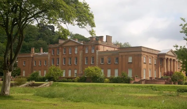
Himley Hall
Historic houses · 1.6 km

Himley House Museum
Museums · 1.6 km

Model Village
Natural landmarks · 1.6 km
Nearby
📷 3Historic bridges · West Midlands
Gravel Hill Bridge
Gravel Hill Bridge — Grade II listed building-listed bridge in england-west-midlands, United Kingdom.
📷 3Memorials & monuments · West Midlands
Wombourne War Memorial
Wombourne War Memorial — Grade II listed building-listed memorial in england-west-midlands, United Kingdom.
📷 5Mountains & hills · West Midlands
Himley Hall Hill
Himley Hall Hill — mountain in england west midlands. Elevation: 143 m.
📷 5📷 3Historic bridges · West Midlands
Staffordshire And Worcestershire Canal Bridge Number 46 (Bumblehole Bridge) And Associated Lock
Staffordshire And Worcestershire Canal Bridge Number 46 (Bumblehole Bridge) And Associated Lock — Grade II listed building-listed bridge in england-west-midlands, United Kingdom.
📷 7Historic pubs · West Midlands
The Dudley Arms
The Dudley Arms in England West Midlands, United Kingdom.
Where to eat & stay near Wombourne
Places to stay
 📷 5
📷 5B&Bs · West Midlands
The Old Court House
The Old Court House — a bed-and-breakfast in england west midlands.
 📷 5
📷 5Hotels · West Midlands
Ramada by Wyndham Park Hall
Ramada by Wyndham Park Hall — a hotel in england west midlands.
 📷 5
📷 5Campsites · West Midlands
Glamping West Midlands
Glamping West Midlands — a campsite in england west midlands.
 📷 5
📷 5 📷 5
📷 5 📷 5
📷 5Hotels · West Midlands
Village Hotel
Village Hotel — a hotel in england west midlands. 3-star. Brand: Village Hotels.
Places to eat & drink
📷 7Historic pubs · West Midlands
The Dudley Arms
The Dudley Arms in England West Midlands, United Kingdom.
 📷 3
📷 3Historic pubs · West Midlands
The Plough Inn
The Plough Inn — Historic pub — listed building or notable heritage status.
 📷 5
📷 5Historic pubs · West Midlands
The Crooked House
The Crooked House in England West Midlands, United Kingdom.
 📷 3
📷 3Historic pubs · West Midlands
The Cross Inn
The Cross Inn — Historic pub — listed building or notable heritage status.
 📷 5
📷 5Historic pubs · West Midlands
The Old Bull's Head Public House And Brewhouse
The Old Bull's Head Public House And Brewhouse in England West Midlands, United Kingdom.
 📷 5
📷 5Historic pubs · West Midlands
The Old Cat Inn
The Old Cat Inn — Historic pub — listed building or notable heritage status.
More museums in this region
 📷 3
📷 3Museums · West Midlands
Redfern Cottage
Redfern Cottage — a museum in england-east-midlands, United Kingdom.
 📷 3
📷 3Museums · West Midlands
Museum of Cannock Chase
Museum of Cannock Chase — a museum in england-east-midlands, United Kingdom.
 📷 5
📷 5Museums · West Midlands
Cannock Chase District
Cannock Chase is a designated Area of Outstanding Natural Beauty and National Landscape in Staffordshire, England. It gives its name to Cannock Chase District, a non-metropolitan local government dist
 📷 5
📷 5Museums · West Midlands
Uttoxeter
Uttoxeter — a museum in england-east-midlands, United Kingdom.
Frequently asked questions
- Where is Wombourne?
- Wombourne is in Staffordshire, the West Midlands, United Kingdom (postcode WV5 0HX), in the parish of Wombourne.
- What is Wombourne?
- Wombourne — a museum in england-west-midlands, United Kingdom.
- How do I get to Wombourne?
- The nearest railway station is Coseley, about 7.0 km away. Drivers can use postcode WV5 0HX.
- How do I get to Wombourne?
- The nearest railway station is Coseley, about 7.0 km away. Drivers can navigate to postcode WV5 0HX.