Reservoirs & lochs · South West England
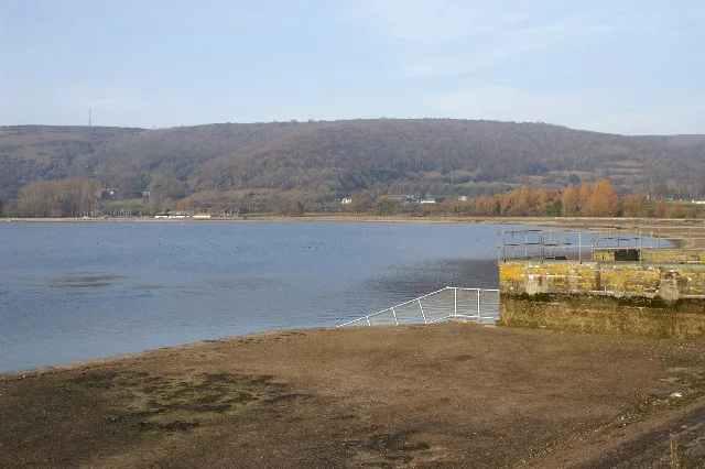
Wistlandpound Reservoir
In or near Kentisbury.
Wistlandpound Reservoir — reservoir in Devon, England, UK.

Wikimedia Commons contributors — see linked file page for photographer and licence licence
Plan your visit
- Typical visit
- 1 h–2.5 h
- Nearest railway station
- Killington Lane · 5.1 km
- Free entry
- Dog-friendly
Getting there & planning your visit
Wistlandpound Reservoir is located in North Devon, with the postcode EX31 4SL. The nearest railway station is Killington Lane, which is 5.1 km away. Entry to the reservoir is free.
About
Wistlandpound Reservoir is a reservoir in the United Kingdom. Wikidata describes it as: "reservoir in Devon, England, UK". Coordinates: 51.1584°, -3.9433°.
Photo gallery
From the Wikipedia article
Wistlandpound Reservoir is a reservoir in Devon, England owned by South West Water. Although final completion was in 1957, the reservoir started supplying the Barnstaple area in September 1956. The earth embankment reservoir holds up to 475,597 cubic metres (16,795,500 cu ft) and covers an area of 18 hectares (44 acres). Situated close to Exmoor National Park, and managed jointly by Forestry England and The South West Lakes Trust, Wistlandpound is a popular recreation area, with bird watching, trout fishing, as well as boating and nature walking among the most popular activities. Calvert Devon has a centre at the Reservoir, providing holiday and activity facilities for those with disabilities and their families, plus schools and large groups. The construction of the reservoir flooded part of the formation of the Lynton and Barnstaple Railway, which can still be seen when water levels are low. The railway, which is being reconstructed, will follow an alternative route around the side of the reservoir. Wistlandpound reservoir is located at grid reference SS642417. The reservoir is used as a water supply, it supplies water to the (former) Ilfracombe urban district (Ilfracombe, Berrynaurbour, Combe Martin, etc) since the disuse of the Slade reservoirs this task has fallen to wistlandpound reservoir, for a short time they would have co-existed as a water supply.
Excerpt from Wikipedia under CC BY-SA 4.0. See the source article linked in Sources below.
- Coordinates
- 51.1584, -3.9433
- County
- Devon
- District
- North Devon
- Parish
- Bratton Fleming
- Postcode
- EX31 4SL
- Parliamentary constituency
- North Devon
- Nearest railway station
- Killington Lane — 5.1 km
Sources
- wikidata: Q7334157 (CC0)
- wikipedia: Wistlandpound Reservoir (CC BY-SA 4.0)
- commons: Wistlandpound Reservoir from the south bank - geograph.org.uk - 1498585.jpg (CC BY-SA 4.0)
Other places nearby

Cracked Barn
Historic houses · 1.0 km

Westland Farm
Campsites · 1.5 km
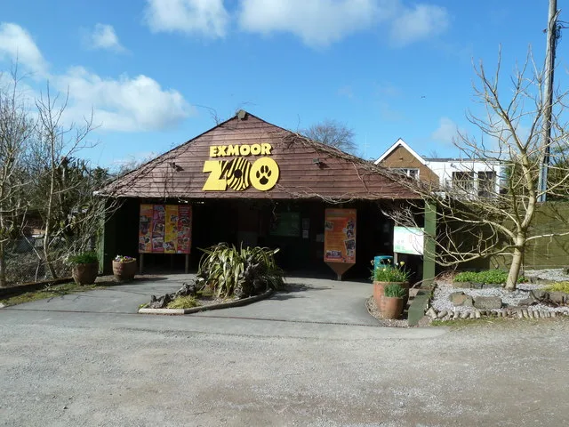
Exmoor Zoo
Zoos & aquariums · 1.8 km

Kentisbury Down
Mountains & hills · 1.8 km

Ruined Tractor
Natural landmarks · 2.0 km

Greenacres Touring Caravan Park
Campsites · 2.1 km

Kentisbury War Memorial
Memorials & monuments · 2.9 km

Kentisbury
Villages · 2.9 km

Arlington, Devon
Museums · 2.9 km

Holwell Barrow
Burial mounds & barrows · 3.1 km

Carriage House
Museums · 3.1 km

Arlington Court
Natural landmarks · 3.3 km
Nearby
📷 3Historic houses · South West England
Cracked Barn
Cracked Barn — a historic house in england-south-west, United Kingdom.
📷 5Flagship📷 10Zoos & aquariums · South West England
Exmoor Zoo
Exmoor Zoo is a zoo or aquarium in the United Kingdom.
📷 5Mountains & hills · South West England
Kentisbury Down
Kentisbury Down — a hill or mountain in england south west.
📷 5Natural landmarks · South West England
Ruined Tractor
Ruined Tractor — a natural landmark in england-south-west, United Kingdom.
📷 5Campsites · South West England
Greenacres Touring Caravan Park
Greenacres Touring Caravan Park — a campsite in england south west.
Where to eat & stay near Wistlandpound Reservoir
Places to stay
📷 5📷 5Campsites · South West England
Greenacres Touring Caravan Park
Greenacres Touring Caravan Park — a campsite in england south west.
 📷 5
📷 5 📷 6
📷 6B&Bs · South West England
Fox And Goose
Fox And Goose — a bed-and-breakfast in england south west.
 📷 5
📷 5Campsites · South West England
South Town Farm Campsite
South Town Farm Campsite — a campsite in england south west.
 📷 4
📷 4Caravan parks · South West England
Wigmore Farm
Wigmore Farm — a caravan park in england south west.
Places to eat & drink
 📷 5
📷 5Historic pubs · South West England
Pack o' Cards
Pack o' Cards in England South West, United Kingdom.
 📷 7
📷 7Historic pubs · South West England
Rising Sun Hotel (Main Part)
Rising Sun Hotel (Main Part) in England South West, United Kingdom.
 📷 7
📷 7Historic pubs · South West England
Rock House Hotel
Rock House Hotel in England South West, United Kingdom.
 📷 5
📷 5Restaurants · South West England
Barum Gate
Barum Gate — a restaurant in england south west. Cuisine: british. Brand: Table Table.
 📷 5
📷 5 📷 5
📷 5Historic pubs · South West England
Royal Exchange Public House
Royal Exchange Public House in England South West, United Kingdom.
More places in this region
 Flagship📷 10
Reservoirs & lochs · South West England
Cheddar Reservoir
Cheddar Reservoir — reservoir in Somerset, England.
 📷 5
📷 5Reservoirs & lochs · South West England
Ashford Reservoir
Ashford Reservoir — reservoir in Somerset, England, UK.
 📷 5
📷 5Reservoirs & lochs · South West England
Burrator Reservoir
Burrator Reservoir — reservoir in Devon, England.
 📷 5
📷 5Reservoirs & lochs · South West England
Chard Reservoir
Chard Reservoir — reservoir in Somerset, England, UK.
Frequently asked questions
- Where is Wistlandpound Reservoir?
- Wistlandpound Reservoir is in Devon, South-West England, United Kingdom (postcode EX31 4SL), in the parish of Bratton Fleming.
- What is Wistlandpound Reservoir?
- Wistlandpound Reservoir — reservoir in Devon, England, UK.
- How do I get to Wistlandpound Reservoir?
- The nearest railway station is Killington Lane, about 5.1 km away. Drivers can use postcode EX31 4SL.
- Is Wistlandpound Reservoir free to visit?
- Yes, Wistlandpound Reservoir is free to enter.
- How do I get to Wistlandpound Reservoir?
- The nearest railway station is Killington Lane, about 5.1 km away. Drivers can navigate to postcode EX31 4SL.