Mountains & hills · Central Scotland
Windlestraw Law
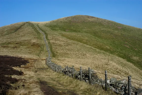
Windlestraw Law — Named summit at 659 m.

Wikimedia Commons contributors — see linked file page for photographer and licence licence
Plan your visit
- Typical visit
- 3 h–8 h
- Best time of year
- Late spring – early autumn (May–Oct)
- Nearest railway station
- Stow · 8.6 km
- Free entry
- Dog-friendly
About
Windlestraw Law is a named summit in the United Kingdom. Wikidata describes it as: "Named summit at 659 m.". Coordinates: 55.6775°, -3.0009°.
Photo gallery
From the Wikipedia article
Windlestraw Law is a hill in the Moorfoot Hills range, part of the Southern Uplands of Scotland. It is the highest peak of the range, and lies north of the town of Innerleithen in the Scottish Borders. A large and boggy peak, it is usually climbed from either its western slopes or the longer route from Tweeddale to the south.
Excerpt from Wikipedia under CC BY-SA 4.0. See the source article linked in Sources below.
- Coordinates
- 55.6775, -3.0009
- Address
- Scottish Borders, Scotland
- Nearest railway station
- Stow — 8.6 km
Sources
- osm: n1364897871 (ODbL)
- wikipedia: Windlestraw Law (CC BY-SA 4.0)
- commons: Windlestraw Law seen from Black Law - geograph.org.uk - 1617130.jpg (CC BY-SA 4.0)
Other places nearby
Loading nearby places…
Nearby
 📷 5
📷 5Mountains & hills · Central Scotland
Redscar Law
Redscar Law — mountain in scotland central. Elevation: 560 m.
 📷 5
📷 5Mountains & hills · Central Scotland
Wallet Knowe
Wallet Knowe — mountain in scotland central. Elevation: 482 m.
 📷 5
📷 5Mountains & hills · Central Scotland
Mossy Rig
Mossy Rig — mountain in scotland central. Elevation: 550 m.
 📷 5
📷 5Mountains & hills · Central Scotland
Deaf Heights
Deaf Heights — mountain in scotland central. Elevation: 565 m.
 📷 5
📷 5Mountains & hills · Central Scotland
Bareback Knowe
Bareback Knowe — mountain in scotland central. Elevation: 505 m.
 📷 5
📷 5Mountains & hills · Central Scotland
Glentress Rig
Glentress Rig — mountain in scotland central. Elevation: 426 m.
Where to eat & stay near Windlestraw Law
Places to stay
 📷 5
📷 5Campsites · Central Scotland
Tweedside Caravan Park
Tweedside Caravan Park — a campsite in scotland central.
 📷 5
📷 5Hotels · Central Scotland
Cardrona Hotel
Cardrona Hotel — a hotel in scotland central.
 📷 5
📷 5Campsites · Central Scotland
Glentress Forest Lodges
Glentress Forest Lodges — a campsite in scotland central.
 📷 5
📷 5Hotels · Central Scotland
Peebles Hydro Hotel
Peebles Hydro Hotel — a hotel in scotland central. Brand: Crieff Hydro Family of Hotels.
 📷 5
📷 5B&Bs · Central Scotland
Whitestone House
Whitestone House — a bed-and-breakfast in scotland central.
 📷 5
📷 5Hotels · Central Scotland
Park Hotel
Park Hotel — a hotel in scotland central.
Places to eat & drink
 📷 5
📷 5Historic pubs · Central Scotland
Clovenfords Hotel, Clovenfords
Clovenfords Hotel, Clovenfords in Scotland Central, United Kingdom.
 📷 5
📷 5Historic pubs · Central Scotland
The Keg Lounge Bar, 11 High Street, Peebles
The Keg Lounge Bar, 11 High Street, Peebles in Scotland Central, United Kingdom.
 📷 5
📷 5Historic pubs · Central Scotland
Red Lion House, 36 Biggiesknowe, Peebles
Red Lion House, 36 Biggiesknowe, Peebles in Scotland Central, United Kingdom.
 📷 5
📷 5Historic pubs · Central Scotland
The Bridge Inn, West Port, Peebles
The Bridge Inn, West Port, Peebles in Scotland Central, United Kingdom.
 📷 5
📷 5Restaurants · Central Scotland
Horse Shoe Inn
Horse Shoe Inn — a restaurant in scotland central.
 📷 5
📷 5Historic pubs · Central Scotland
Town Arms Inn, 1 Market Place, Selkirk
Town Arms Inn, 1 Market Place, Selkirk in Scotland Central, United Kingdom.
More mountains in this region
 📷 3
📷 3Mountains & hills · Central Scotland
Abbey Hill
Abbey Hill — Named summit at 278 m.
 📷 3
📷 3Mountains & hills · Central Scotland
Aberlady Bay
Aberlady Bay — bay on the north coast of East Lothian, Scotland, UK.
 📷 3
📷 3Mountains & hills · Central Scotland
Allermuir Hill
Allermuir Hill — Named summit at 493 m.
 📷 3
📷 3Mountains & hills · Central Scotland
Ardnandave
Ardnandave — Named summit at 715 m.
Frequently asked questions
- Where is Windlestraw Law?
- Windlestraw Law is in central Scotland, United Kingdom.
- What is Windlestraw Law?
- Windlestraw Law — Named summit at 659 m.
- How do I get to Windlestraw Law?
- The nearest railway station is Stow, about 8.6 km away. Its coordinates are 55.6775°, -3.0009°.
- Is Windlestraw Law free to visit?
- Yes, Windlestraw Law is free to enter.