
Mountains & hills · Scottish Lowlands
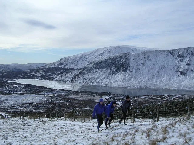
White Coomb
White Coomb — Named summit at 821 m.

Wikimedia Commons contributors — see linked file page for photographer and licence licence

Plan your visit
- Typical visit
- 3 h–8 h
- Best time of year
- Late spring – early autumn (May–Oct)
- Free entry
- Dog-friendly
About
White Coomb is a named summit in the United Kingdom. Wikidata describes it as: "Named summit at 821 m.". Coordinates: 55.4226°, -3.3237°.
Photo gallery
Official information
White Coomb is a notable hill located in the Southern Uplands of Scotland. It is part of the Database of British and Irish Hills and is popular among hill walkers and baggers for its elevation and scenic views.
From the Wikipedia article
White Coomb is a hill in the Moffat Hills range, part of the Southern Uplands of Scotland. Its broad summit is the highest point in the range and the registration county of Dumfriesshire, as well as being the fourth highest point in southern Scotland, however, despite this, it is largely concealed by other hills on all sides except its east and south east, making this the only direction from which its full scale can be seen. White Coomb is most easily climbed from the National Trust for Scotland car park underneath the Grey Mare's Tail waterfall, on the A708 from Moffat to Selkirk, at NT 186146. The most direct route heads directly west up a steep ridge, but a more comfortable route follows a well built footpath above the north side of the waterfall. Above the waterfall, the fast flowing Tail Burn must be crossed to avoid a long detour; although there are plenty of natural stepping stones, spate or icy conditions may make their use dangerous. From across the stream, the best route through the peat and heather follows the course of a wall leading to the summit of Upper Tarnberry. From there, the east ridge, which is steep and craggy in places, leads to the broad summit. An alternative ascent, described by the Daily Telegraph as one of "Britain's finest half-day and day walks", follows the Tail Burn to the outlet of Loch Skeen before ascending the ridge to Mid Craig, and passing Donald's Cleuch Head to reach the summit. The descent suggested is via Rough Craig and south to join the road and walk back to the start point.
Excerpt from Wikipedia under CC BY-SA 4.0. See the source article linked in Sources below.
- Coordinates
- 55.4226, -3.3237
- Address
- Dumfries and Galloway, Scotland
- Official site
- www.hills-database.co.uk
Sources
- osm: n618913739 (ODbL)
- wikipedia: White Coomb (CC BY-SA 4.0)
- commons: WhiteCoomb.jpg (CC BY-SA 4.0)
Other places nearby

White Coomb
Natural landmarks · 0.0 km

Carrifran Gans
Mountains & hills · 1.3 km
Loch Skeen
Natural landmarks · 1.6 km

Grey Mare's Tail (NTS)
Natural landmarks · 2.0 km

Grey Mare's Tail (NTS)
Waterfalls · 2.0 km
Grey Mare's Tail (waterfall)
Viewpoints · 2.1 km

Great Hill
Mountains & hills · 2.2 km

Watch Knowe
Mountains & hills · 2.3 km

Grey Mare’s Tail
Waterfalls · 2.6 km

Lochcraig Head
Mountains & hills · 2.7 km
Lochcraig Head
Mountains & hills · 2.7 km

Molls Cleuch Dod
Mountains & hills · 3.1 km
Nearby
📷 3Natural landmarks · Scottish Lowlands
White Coomb
White Coomb — 821m high mountain in Dumfries and Galloway, Scotland, UK.
📷 5Mountains & hills · Scottish Lowlands
Carrifran Gans
Carrifran Gans — a hill or mountain in scotland lowlands.
📷 3Natural landmarks · Scottish Lowlands
Loch Skeen
Loch Skeen — lake in Dumfries and Galloway, Scotland, UK, outflows south to Tail Burn.
📷 3Natural landmarks · Scottish Lowlands
Grey Mare's Tail (NTS)
Grey Mare's Tail (NTS) — a place in Scottish Lowlands, United Kingdom.
📷 5Waterfalls · Scottish Lowlands
Grey Mare's Tail (NTS)
Grey Mare's Tail (NTS) — waterfall in scotland lowlands.
📷 3Viewpoints · Scottish Lowlands
Grey Mare's Tail (waterfall)
Grey Mare's Tail (waterfall) is a viewpoint in the United Kingdom.
Where to eat & stay near White Coomb
Places to stay
 📷 5
📷 5 📷 5
📷 5B&Bs · Scottish Lowlands
Capperkirk
Capperkirk — a bed-and-breakfast in scotland lowlands.
 📷 5
📷 5Caravan parks · Scottish Lowlands
Angecroft Caravan Park
Angecroft Caravan Park — a caravan park in scotland lowlands.
 📷 7
📷 7Hotels · Scottish Lowlands
Buccleuch Arms Hotel
Buccleuch Arms Hotel — a hotel in scotland lowlands.
 📷 5
📷 5Campsites · Scottish Lowlands
Moffat Camping & Caravanning Club site
Moffat Camping & Caravanning Club site — a campsite in scotland lowlands.
 📷 5
📷 5Places to eat & drink
 📷 7
📷 7Historic pubs · Scottish Lowlands
Post Horn Hotel, Crawford
Post Horn Hotel, Crawford in Scotland Lowlands, United Kingdom.
More mountains in this region
 📷 3
📷 3 📷 5
📷 5Mountains & hills · Scottish Lowlands
Aros Bay
Aros Bay — bay on Islay, Argyll and Bute, Scotland, UK.
 📷 3
📷 3Mountains & hills · Scottish Lowlands
Beinn Bharrain
Beinn Bharrain — Named summit at 717 m.
 📷 5
📷 5Frequently asked questions
- Where is White Coomb?
- White Coomb is in the Scottish Lowlands, United Kingdom.
- What is White Coomb?
- White Coomb — Named summit at 821 m.
- How do I get to White Coomb?
- Its coordinates are 55.4226°, -3.3237°.
- Is White Coomb free to visit?
- Yes, White Coomb is free to enter.