Aqueducts · Scottish Highlands
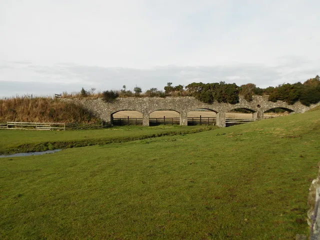
West Wellbank Aqueduct, Murroes
West Wellbank Aqueduct, Murroes — aqueduct in Angus, Scotland, UK.

Wikimedia Commons contributors — see linked file page for photographer and licence licence
Plan your visit
- Typical visit
- 30 min–1 h
- Nearest railway station
- Balmossie · 6.5 km
- Free entry
- Dog-friendly
About
West Wellbank Aqueduct, Murroes is a place of interest in the Scottish Highlands. Officially recognised as category B listed building. It sits within the Arbroath and Broughty Ferry parliamentary constituency. The nearest railway station is Balmossie, about 6.5 km away. Postcode area DD5.
Photo gallery
Place summary
West Wellbank Aqueduct is an aqueduct located in Murroes, in the Scottish Highlands (postcode DD5). It is designated as a category B listed building, highlighting its architectural and historical significance.
AI-generated from the structured facts on this page (operator, designation, listing, era). Not a substitute for visiting.
- Coordinates
- 56.5285, -2.8793
- District
- Angus
- Postcode
- DD5 3PP
- Parliamentary constituency
- Arbroath and Broughty Ferry
- Nearest railway station
- Balmossie — 6.5 km
Sources
- wikidata: Q17770479 (CC0)
- commons: Aqueduct in West Wellbank Wood - geograph.org.uk - 5206730.jpg (CC BY-SA 4.0)
Other places nearby
Loading nearby places…
Nearby
_(14801986203).jpg?width=1200) 📷 3
📷 3Historic houses · Scottish Highlands
Gagie House, Gagie
Gagie House, Gagie — architectural structure in Angus, Scotland, UK.
 📷 3
📷 3Memorials & monuments · Scottish Highlands
Wellbank War Memorial
Wellbank War Memorial — a memorial in scotland-highlands, United Kingdom.
 📷 3
📷 3Towns & cities · Scottish Highlands
Wellbank
Wellbank — village in Angus, Scotland, UK.
 📷 3
📷 3Aqueducts · Scottish Highlands
Aqueduct, Gagie Estate
Aqueduct, Gagie Estate — aqueduct in Angus, Scotland, UK.
 📷 3
📷 3Historic bridges · Scottish Highlands
Road Bridge, Gagie Estate
Road Bridge, Gagie Estate — category C listed building-listed bridge in scotland-highlands, United Kingdom.
 📷 5
📷 5Historic bridges · Scottish Highlands
Bridge, Westhall Terrace, Murroes
Bridge, Westhall Terrace, Murroes — category C listed building-listed bridge in scotland-highlands, United Kingdom.
More places in this region
Frequently asked questions
- Where is West Wellbank Aqueduct, Murroes?
- West Wellbank Aqueduct, Murroes is in the Scottish Highlands, United Kingdom (postcode DD5 3PP).
- Is West Wellbank Aqueduct, Murroes a listed building?
- West Wellbank Aqueduct, Murroes is officially recognised as category B listed building listed.
- Is West Wellbank Aqueduct, Murroes free to visit?
- Yes, West Wellbank Aqueduct, Murroes is free to enter.
- How do I get to West Wellbank Aqueduct, Murroes?
- The nearest railway station is Balmossie, about 6.5 km away. Drivers can navigate to postcode DD5 3PP.