
Historic houses · South East England
West Farleigh Hall
In or near Nettlestead.
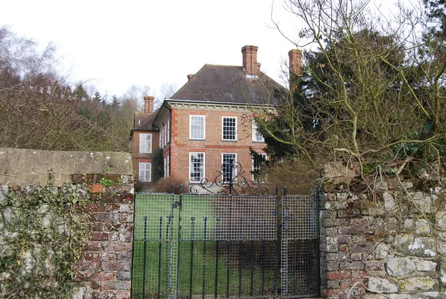
West Farleigh Hall — a Grade I-listed historic house in england-london, United Kingdom.

S Westerman — CC BY-SA 2.0 via Wikimedia Commons licence

Plan your visit
- Typical visit
- 1 h–2 h
- Nearest railway station
- Wateringbury · 2.2 km
- Family-friendly
- Limited wheelchair access
Getting there & planning your visit
To visit West Farleigh Hall, the nearest railway station is Wateringbury, which is 2.2 km away. The postcode for sat-nav is ME15 0PE. Please note that wheelchair accessibility is limited.
About
West Farleigh Hall is a Grade I-listed building in england-london, United Kingdom. Grade I status is conferred by Historic England (or Cadw, Historic Environment Scotland or NIEA equivalents) on buildings of exceptional national interest. See the linked Wikipedia article for full historical and architectural details.
Photo gallery
See it from the streetimagery from 2025
Imagery © Mapillary contributors, CC BY-SA 4.0
Protected designations
- Area of Outstanding Natural Beauty: Kent Downs
Designations sourced from Natural England open data under OGL v3.
From the Wikipedia article
Smiths Hall, known as West Farleigh Hall from the early 20th century until the 1990s, is an 18th-century country house in West Farleigh, Kent.
Excerpt from Wikipedia under CC BY-SA 4.0. See the source article linked in Sources below.
Background
History
A house on the site of Smiths Hall was owned by the Brewer family from the mid-15th century until 1762 when the house and estate was left by Jane Brewer to her cousin Rev. John Davis, Rector of Hamsey, East Sussex. Davis died in 1766 and the estate passed to his son Sir John Davis who sold it in 1774 to William Perrin. Perrin died in 1820. By 1838, the house was owned by Sir Henry FitzHerbert, Around 1921, Henry Arthur Hannen son of the Baron Hannen was living in the hall.
Architecture
The current house was constructed in 1719 as recorded in the dated rainwater hoppers. It is two-storeys and brick-built with a plain tile roof. The main façade on the west side is nine bays wide arranged symmetrically around a central doorway. The pale red brick façade is divided by projecting brick pilasters of darker red rubbed bricks into three equal sized sections. The first floor has nine sash windows of twelve panes with curved tops - three in each section. the ground floor window arrangement repeats that of the first floor except that the central doorway replaces the central window. The windows on both floors are framed in dark red rubbed bricks with the central voussoir brick…
Sourced from Wikipedia under CC BY-SA 4.0.
- Coordinates
- 51.2469, 0.4534
- County
- Kent
- District
- Maidstone
- Parish
- West Farleigh
- Postcode
- ME15 0PE
- Parliamentary constituency
- Weald of Kent
- Established
- 1719
- Nearest railway station
- Wateringbury — 2.2 km
Sources
- wikidata: Q7985143 (CC0)
- wikipedia: Smiths Hall (CC BY-SA 4.0)
Other places nearby
Smith's Hall
Manor houses · 0.0 km

The Tickled Trout
Historic pubs · 0.1 km

West Farleigh
Historic churches · 0.4 km

Teston Lane
Historic bridges · 0.8 km
Teston Bridge
Historic bridges · 0.8 km

Orchard View Park
Campsites · 0.8 km

All Saints Church, West Farleigh
Historic churches · 0.9 km

East Barming
Villages · 1.0 km

St Peter's and St Paul's Church, Teston
Historic churches · 1.2 km

Teston
Historic churches · 1.3 km
Buston Manor
Stately homes · 1.6 km

Wateringbury railway station
Heritage railway stations · 2.2 km
Nearby
📷 5Manor houses · South East England
Smith's Hall
Smith's Hall — a manor in england-london, United Kingdom.
📷 7Historic pubs · South East England
The Tickled Trout
The Tickled Trout in England South East, United Kingdom.
📷 5Historic churches · South East England
West Farleigh
West Farleigh — a church in england-london, United Kingdom.
📷 5Historic bridges · South East England
Teston Lane
Teston Lane is a historic bridge in the United Kingdom.
📷 5Historic bridges · South East England
Teston Bridge
Teston Bridge — a Grade I-listed bridge in england-london, United Kingdom.
📷 5Where to eat & stay near West Farleigh Hall
Places to stay
📷 5 📷 5
📷 5Campsites · South East England
Hamlet Wood Scout Campsite
Hamlet Wood Scout Campsite — a campsite in england london. Brand: The Scout Association.
 📷 5
📷 5Campsites · South East England
Whitewater Action Medway
Whitewater Action Medway — a campsite in england london.
 📷 5
📷 5 📷 5
📷 5Campsites · South East England
Lower Grange Farm Scout Activity Centre
Lower Grange Farm Scout Activity Centre — a campsite in england london.
 📷 5
📷 5Caravan parks · South East England
Lamb's Caravan Park
Lamb's Caravan Park — a caravan park in england south east.
Places to eat & drink
📷 7Historic pubs · South East England
The Tickled Trout
The Tickled Trout in England South East, United Kingdom.
 📷 7
📷 7Historic pubs · South East England
The Horse Shoes Public House
The Horse Shoes Public House in England South East, United Kingdom.
 📷 5
📷 5Historic pubs · South East England
The White Lion Public House
The White Lion Public House in England South East, United Kingdom.
 📷 7
📷 7Historic pubs · South East England
The King And Queen Public House
The King And Queen Public House in England South East, United Kingdom.
 📷 5
📷 5 📷 5
📷 5Historic pubs · South East England
The Royal Albion Inn
The Royal Albion Inn in England South East, United Kingdom.
More historic houses in this region
 📷 5
📷 5Historic houses · South East England
12 and 14 High Street, Rochester
12 and 14 High Street, Rochester — building in Rochester, Kent, England, UK.
 📷 5
📷 5Historic houses · South East England
Berkeley House
Berkeley House — house in Rochester, Kent, England, UK.
.jpg?width=1200) 📷 5
📷 5Historic houses · South East England
Betchworth House
Betchworth House — house in Betchworth, Mole Valley, England, UK.
 📷 5
📷 5Historic houses · South East England
Bookham Grove
Bookham Grove — building in Mole Valley, Surrey, England, UK.
Frequently asked questions
- Where is West Farleigh Hall?
- West Farleigh Hall is in Kent, London, United Kingdom (postcode ME15 0PE), in the parish of West Farleigh.
- What is West Farleigh Hall?
- West Farleigh Hall — a Grade I-listed historic house in england-london, United Kingdom.
- How do I get to West Farleigh Hall?
- The nearest railway station is Wateringbury, about 2.2 km away. Drivers can use postcode ME15 0PE.
- When was West Farleigh Hall built?
- Built or established in 1719.
- Is West Farleigh Hall a listed building?
- West Farleigh Hall is officially recognised as Grade I listed.
- Is West Farleigh Hall a protected site?
- Yes — West Farleigh Hall is part of the Kent Downs National Landscape (AONB).
- How do I get to West Farleigh Hall?
- The nearest railway station is Wateringbury, about 2.2 km away. Drivers can navigate to postcode ME15 0PE.