Holy wells · Yorkshire & the Humber
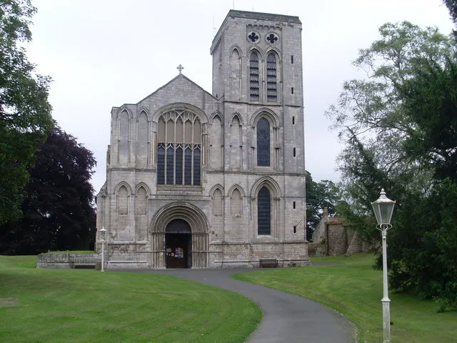
Walls Bounding Churchyard Of St Mary's Priory Church
In or near Westow.
Walls Bounding Churchyard Of St Mary's Priory Church — Grade I listed wall in Ryedale, United Kingdom.

Wikimedia Commons contributors — see linked file page for photographer and licence licence
Plan your visit
- Typical visit
- 15 min–30 min
- Nearest railway station
- Malton · 1.7 km
- Free entry
- Dog-friendly
About
Walls Bounding Churchyard Of St Mary's Priory Church is a place of interest in Yorkshire. Officially recognised as Grade I listed building. The site is a designated Site of Special Scientific Interest. It sits within the Thirsk and Malton parliamentary constituency. The nearest railway station is Malton, about 1.7 km away. Postcode area YO17.
Photo gallery
Protected designations
- Site of Special Scientific Interest: River Derwent SSSI
Designations sourced from Natural England open data under OGL v3.
Place summary
The Walls Bounding Churchyard of St Mary's Priory Church is located in Malton, Yorkshire. This Grade I listed building is part of a site designated as a Site of Special Scientific Interest (SSSI) due to its proximity to the River Derwent SSSI.
AI-generated from the structured facts on this page (operator, designation, listing, era). Not a substitute for visiting.
- Coordinates
- 54.1424, -0.7793
- District
- North Yorkshire
- Parish
- Malton
- Postcode
- YO17 7HB
- Parliamentary constituency
- Thirsk and Malton
- Nearest railway station
- Malton — 1.7 km
Sources
- wikidata: Q17525587 (CC0)
- commons: Final Resting Place - geograph.org.uk - 1931532.jpg (CC BY-SA 4.0)
Other places nearby
Priory Church of St Mary
Historic churches · 0.0 km

Millenium Garden of Peace
Cemeteries · 0.1 km

Old Malton
Villages · 0.4 km
Derventio Brigantum
Archaeological sites · 1.0 km

Eden Camp Museum
Museums · 1.0 km

Derventio
Archaeological sites · 1.1 km

Norton
Villages · 1.1 km

The Old Lodge
Manor houses · 1.2 km
Malton Castle
Castles · 1.2 km
The Union
Historic pubs · 1.2 km

Site of Malton Castle
Castles · 1.2 km

Malton Cemetery
Cemeteries · 1.2 km
Nearby
📷 3Historic churches · Yorkshire & the Humber
Priory Church of St Mary
Priory Church of St Mary — church in Malton, Ryedale, North Yorkshire, England, UK.
📷 3Cemeteries · Yorkshire & the Humber
Millenium Garden of Peace
Millenium Garden of Peace is a cemetery in the United Kingdom.
📷 5📷 3Archaeological sites · Yorkshire & the Humber
Derventio Brigantum
Derventio Brigantum — Roman fort located at present-day Malton, North Yorkshire, England, UK.
📷 3Museums · Yorkshire & the Humber
Eden Camp Museum
Eden Camp Museum — a museum in england-yorkshire, United Kingdom.
📷 3Archaeological sites · Yorkshire & the Humber
Derventio
Derventio — a archaeological in england-yorkshire, United Kingdom.
Where to eat & stay near Walls Bounding Churchyard Of St Mary's Priory Church
Places to stay
 📷 5
📷 5Caravan parks · Yorkshire & the Humber
Brickyard Lakes Country Park
Brickyard Lakes Country Park — a caravan park in england yorkshire.
 📷 5
📷 5Campsites · Yorkshire & the Humber
Thornthorpe Caravan & Camping Site
Thornthorpe Caravan & Camping Site — a campsite in england yorkshire.
 📷 5
📷 5 📷 5
📷 5Caravan parks · Yorkshire & the Humber
Hill Top Farm Caravans
Hill Top Farm Caravans — a caravan park in england yorkshire.
 📷 5
📷 5 📷 5
📷 5Campsites · Yorkshire & the Humber
Midsummer Camping
Midsummer Camping — a campsite in england yorkshire.
Places to eat & drink
📷 5 📷 7
📷 7Historic pubs · Yorkshire & the Humber
The Cross Keys Public House
The Cross Keys Public House in England Yorkshire, United Kingdom.
 📷 7
📷 7Historic pubs · Yorkshire & the Humber
The Blue Ball Public House And Attached Outbuildings At Rear
The Blue Ball Public House And Attached Outbuildings At Rear in England Yorkshire, United Kingdom.
 📷 5
📷 5Historic pubs · Yorkshire & the Humber
The New Globe Public House
The New Globe Public House in England Yorkshire, United Kingdom.
 📷 5
📷 5Historic pubs · Yorkshire & the Humber
The Golden Lion Public House
The Golden Lion Public House in England Yorkshire, United Kingdom.
 📷 5
📷 5Historic pubs · Yorkshire & the Humber
The Spotted Cow Public House
The Spotted Cow Public House in England Yorkshire, United Kingdom.
More places in this region
 📷 3
📷 3Holy wells · Yorkshire & the Humber
Portion of town wall to rear of Numbers 9 to 13 Town Wall
Portion of town wall to rear of Numbers 9 to 13 Town Wall — Grade II listed building in Stockport, Greater Manchester, England, UK.
 📷 3
📷 3Holy wells · Yorkshire & the Humber
Curtain Wall
Curtain Wall — Grade I listed wall in York, United Kingdom.
 📷 3
📷 3Holy wells · Yorkshire & the Humber
Garden walls and gatepiers to the Abbey House
Garden walls and gatepiers to the Abbey House — Grade I listed wall in Whitby, North Yorkshire, England, UK.
 📷 3
📷 3Holy wells · Yorkshire & the Humber
Gatehouse And Walls Adjoining To Bishopthorpe Palace
Gatehouse And Walls Adjoining To Bishopthorpe Palace — wall in Bishopthorpe, City of York, England, UK.
Frequently asked questions
- Where is Walls Bounding Churchyard Of St Mary's Priory Church?
- Walls Bounding Churchyard Of St Mary's Priory Church is in Yorkshire, United Kingdom (postcode YO17 7HB), in the parish of Malton.
- What is Walls Bounding Churchyard Of St Mary's Priory Church?
- Walls Bounding Churchyard Of St Mary's Priory Church — Grade I listed wall in Ryedale, United Kingdom.
- How do I get to Walls Bounding Churchyard Of St Mary's Priory Church?
- The nearest railway station is Malton, about 1.7 km away. Drivers can use postcode YO17 7HB.
- Is Walls Bounding Churchyard Of St Mary's Priory Church a listed building?
- Walls Bounding Churchyard Of St Mary's Priory Church is officially recognised as Grade I listed building listed.
- Is Walls Bounding Churchyard Of St Mary's Priory Church a protected site?
- Yes — Walls Bounding Churchyard Of St Mary's Priory Church is part of the River Derwent SSSI Site of Special Scientific Interest.
- Is Walls Bounding Churchyard Of St Mary's Priory Church free to visit?
- Yes, Walls Bounding Churchyard Of St Mary's Priory Church is free to enter.
- How do I get to Walls Bounding Churchyard Of St Mary's Priory Church?
- The nearest railway station is Malton, about 1.7 km away. Drivers can navigate to postcode YO17 7HB.