
Historic churches · East Midlands
Waddingworth
In or near Old Woodhall.
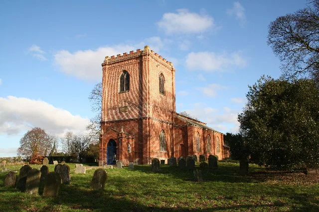
Waddingworth is a hamlet and civil parish in the East Lindsey district of Lincolnshire, England, and approximately 5 miles (8 km) north-west from the town of Horncastle. The parish church is almost on

A Riley — CC BY-SA 2.0 via Wikimedia Commons licence

Plan your visit
- Typical visit
- 30 min–1 h
- Free entry
About
Waddingworth is a hamlet and civil parish in the East Lindsey district of Lincolnshire, England, and approximately 5 miles (8 km) north-west from the town of Horncastle. The parish church is almost on the spot that is claimed to be the centre of Lincolnshire. The name 'Waddingworth' means 'enclosure of the people of Wada'. At the time of the 1086 Domesday Book, "Waldingurde" or "Wadingurde" consisted of 60 households. The former parish church and mortuary chapel of Saint Margaret dates to the 13th or 14th century. In 1808 it was recorded as dilapidated and in the same year was rebuilt. It was again reported dilapidated in 1904 and was restored in 1913 by H. F. Traylen. The church was later used as a store and is now disused. It was built of greenstone with brick patching. Built into the stonework over the door is the carved top of a 13th-century grave slab. The interior retains a 13th-century font.
Photo gallery
Protected designations
- Area of Outstanding Natural Beauty: Lincolnshire Wolds
Designations sourced from Natural England open data under OGL v3.
From the Wikipedia article
Waddingworth is a hamlet and civil parish in the East Lindsey district of Lincolnshire, England, and approximately 5 miles (8 km) north-west from the town of Horncastle. The parish church is almost on the spot that is claimed to be the centre of Lincolnshire. The name 'Waddingworth' means 'enclosure of the people of Wada'. At the time of the 1086 Domesday Book, "Waldingurde" or "Wadingurde" consisted of 60 households. The former parish church and mortuary chapel of Saint Margaret dates to the 13th or 14th century. In 1808 it was recorded as dilapidated and in the same year was rebuilt. It was again reported dilapidated in 1904 and was restored in 1913 by H. F. Traylen. The church was later used as a store and is now disused. It was built of greenstone with brick patching. Built into the stonework over the door is the carved top of a 13th-century grave slab. The interior retains a 13th-century font.
Excerpt from Wikipedia under CC BY-SA 4.0. See the source article linked in Sources below.
- Coordinates
- 53.2225, -0.2198
- County
- Lincolnshire
- District
- East Lindsey
- Parish
- Waddingworth
- Postcode
- LN10 5EE
- Parliamentary constituency
- Louth and Horncastle
Sources
- wikipedia: Waddingworth (CC BY-SA 4.0)
Other places nearby

Gautby
Historic churches · 2.1 km

Horsington, Lincolnshire
Historic churches · 2.2 km

Bucknall, Lincolnshire
Historic churches · 2.5 km

Horsington
Villages · 2.5 km

Minting
Historic churches · 2.5 km

Minting Priory
Abbeys & priories · 2.6 km

Old Woodhall
Towns & cities · 4.3 km

Edlington
Villages · 4.5 km

Baumber
Historic churches · 4.6 km

Thimbleby, Lincolnshire
Historic churches · 4.7 km

Halstead Hall
Archaeological sites · 4.7 km
Church of St. Swithin, Baumber
Historic churches · 4.8 km
Nearby
📷 5Historic churches · East Midlands
Gautby
Gautby ( GAWT-bee) is a village in the East Lindsey district of Lincolnshire, England. The village is situated 6 miles (10 km) north-west from the town of Horncastle, and is part of the Minting civil
📷 5Historic churches · East Midlands
Horsington, Lincolnshire
Horsington, Lincolnshire — a church in england-east-midlands, United Kingdom.
📷 5Historic churches · East Midlands
Bucknall, Lincolnshire
Bucknall, Lincolnshire — a church in england-east-midlands, United Kingdom.
📷 5📷 5Historic churches · East Midlands
Minting
Minting — a church in england-east-midlands, United Kingdom.
📷 3Abbeys & priories · East Midlands
Minting Priory
Minting Priory — a abbey in england-east-midlands, United Kingdom.
Where to eat & stay near Waddingworth
Places to stay
 📷 5
📷 5Campsites · East Midlands
Stockshill Caravan Park
Stockshill Caravan Park — a campsite in england east midlands.
 📷 3
📷 3Campsites · East Midlands
Forest View Camping
Forest View Camping — a campsite in england east midlands.
 📷 5
📷 5Campsites · East Midlands
Ashby Park
Ashby Park — a campsite in england east midlands.
 📷 5
📷 5Campsites · East Midlands
Woodhall Country Park
Woodhall Country Park — a campsite in england east midlands.
 📷 5
📷 5 📷 5
📷 5Places to eat & drink
 📷 5
📷 5 📷 5
📷 5Historic pubs · East Midlands
Abbey Lodge Inn
Abbey Lodge Inn in England East, United Kingdom.
 📷 5
📷 5Historic pubs · East Midlands
Fortescue Arms And Coach House
Fortescue Arms And Coach House in England East, United Kingdom.
 📷 5
📷 5Historic pubs · East Midlands
Lea Gate Public House
Lea Gate Public House in England East, United Kingdom.
 📷 5
📷 5Historic pubs · East Midlands
Star And Garter Public House
Star And Garter Public House in England East, United Kingdom.
 📷 5
📷 5More places in this region
 📷 5
📷 5Historic churches · East Midlands
All Saints' Church, Stamford
All Saints' Church, Stamford — church in Stamford, Lincolnshire, England, UK.
 📷 5
📷 5Historic churches · East Midlands
Church of All Saints
Church of All Saints — church in Little Casterton, Rutland, United Kingdom.
 📷 5
📷 5Historic churches · East Midlands
Church of All Saints
Church of All Saints — church in Fenland, UK.
 📷 5
📷 5Historic churches · East Midlands
Church of St Leonard
Church of St Leonard — church in Fenland, UK.
Frequently asked questions
- Where is Waddingworth?
- Waddingworth is in Lincolnshire, the East Midlands, United Kingdom (postcode LN10 5EE), in the parish of Waddingworth.
- What is Waddingworth?
- Waddingworth is a hamlet and civil parish in the East Lindsey district of Lincolnshire, England, and approximately 5 miles (8 km) north-west from the town of Horncastle. The parish church is almost on
- How do I get to Waddingworth?
- Drivers can use postcode LN10 5EE.
- Is Waddingworth a protected site?
- Yes — Waddingworth is part of the Lincolnshire Wolds National Landscape (AONB).
- Is Waddingworth free to visit?
- Yes, Waddingworth is free to enter.
- How do I get to Waddingworth?
- Drivers can navigate to postcode LN10 5EE. It sits within the Louth and Horncastle parliamentary constituency.