
Islands · Scottish Islands
Uyea
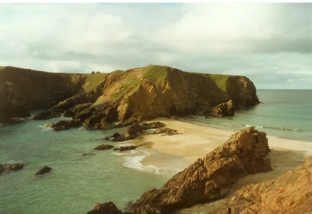
Uyea — an uninhabited tidal island located to the northwest of Mainland, Shetland.

Wikimedia Commons contributors — see linked file page for photographer and licence licence

Plan your visit
- Typical visit
- 4 h–12 h
- Free entry
- Dog-friendly
Getting there & planning your visit
Uyea is a remote island in the Scottish Islands with no railway station or postcode available. Entry to the island is free.
About
Uyea is a island in the United Kingdom. It covers approximately 45 km². Wikidata describes it as: "an uninhabited tidal island located to the northwest of Mainland, Shetland". Coordinates: 60.6222°, -1.4189°.
Photo gallery
From the Wikipedia article
Uyea (Scots: Öya in Shetland dialect spelling) is an uninhabited tidal island located to the northwest of Mainland, Shetland. Uyea lies off the Northmavine peninsula, from where it can be reached by foot at low tide. The island's highest elevation is 70 metres (230 ft) and its area is 45 hectares (0.17 sq mi). There are several natural arches on its rocky coast, as well as challenging rock climbs. Surrounding skerries include Big Nev, Dorra Stack, Little Nev, Out Shuna Stack, Robert Irvine's Skerry, and The Burrier.
Excerpt from Wikipedia under CC BY-SA 4.0. See the source article linked in Sources below.
- Coordinates
- 60.6222, -1.4189
- Official site
- www.ordnancesurvey.co.uk
Sources
- wikidata: Q7904154 (CC0)
- wikipedia: Uyea, Northmavine (CC BY-SA 4.0)
- commons: Uyeanorthmavine.jpg (CC BY-SA 4.0)
Other places nearby
North Wick
Mountains & hills · 0.8 km

Burrier Wick
Natural landmarks · 1.0 km
North Hill
Mountains & hills · 2.0 km

South Wick
Natural landmarks · 2.6 km

Beorgs of Uyea,stone implement working site and chambered cairn
Archaeological sites · 3.5 km

Sand Voe
Natural landmarks · 3.8 km
Hevdadale Hill
Mountains & hills · 4.0 km

Saefti Hill
Mountains & hills · 4.0 km
Brunt Hill
Mountains & hills · 4.0 km
Saefti Hill
Mountains & hills · 4.0 km
Brunt Hill
Mountains & hills · 4.0 km

Beorgs of Uyea
Mountains & hills · 4.3 km
Nearby
📷 3Mountains & hills · Scottish Islands
North Wick
North Wick — bay on North Mainland, Shetland Islands, Scotland, UK.
📷 5Natural landmarks · Scottish Islands
Burrier Wick
Burrier Wick — a natural feature in scotland islands.
📷 5Mountains & hills · Scottish Islands
North Hill
North Hill — mountain in scotland islands. Elevation: 107 m.
📷 5📷 3Archaeological sites · Scottish Islands
Beorgs of Uyea,stone implement working site and chambered cairn
Beorgs of Uyea,stone implement working site and chambered cairn — architectural structure in Shetland Islands, Scotland, UK.
📷 5Where to eat & stay near Uyea
Places to stay
 📷 5
📷 5Caravan parks · Scottish Islands
Braewick Caravan Park
Braewick Caravan Park — a caravan park in scotland islands.
 📷 5
📷 5 📷 5
📷 5Campsites · Scottish Islands
Burravoe Pier Trust Campsite
Burravoe Pier Trust Campsite — a campsite in scotland islands.
Places to eat & drink
 📷 7
📷 7Historic pubs · Scottish Islands
The Booth, Hillswick House, Hillswick
The Booth, Hillswick House, Hillswick in England South East, United Kingdom.
More places in this region
 📷 5
📷 5Islands · Scottish Islands
Bac Beag
Bac Beag — Scottish island, part of the Treshnish Isles in the Inner Hebrides.
 📷 5
📷 5Islands · Scottish Islands
Bac Mòr
Bac Mòr — island in Argyll and Bute, Scotland, UK, one of the Treshnish Isles.
 Flagship📷 3
Islands · Scottish Islands
Baleshare
Baleshare — flat tidal island in the Outer Hebrides, Scotland, UK.
 Flagship📷 5
Islands · Scottish Islands
Barra
Barra — island in Outer Hebrides, Scotland, UK.
Frequently asked questions
- Where is Uyea?
- Uyea is in the Scottish Islands, United Kingdom.
- What is Uyea?
- Uyea — an uninhabited tidal island located to the northwest of Mainland, Shetland.
- How do I get to Uyea?
- Its coordinates are 60.6222°, -1.4189°.
- Is Uyea free to visit?
- Yes, Uyea is free to enter.