Wildlife reserves · West Midlands
Upper Ray Meadows
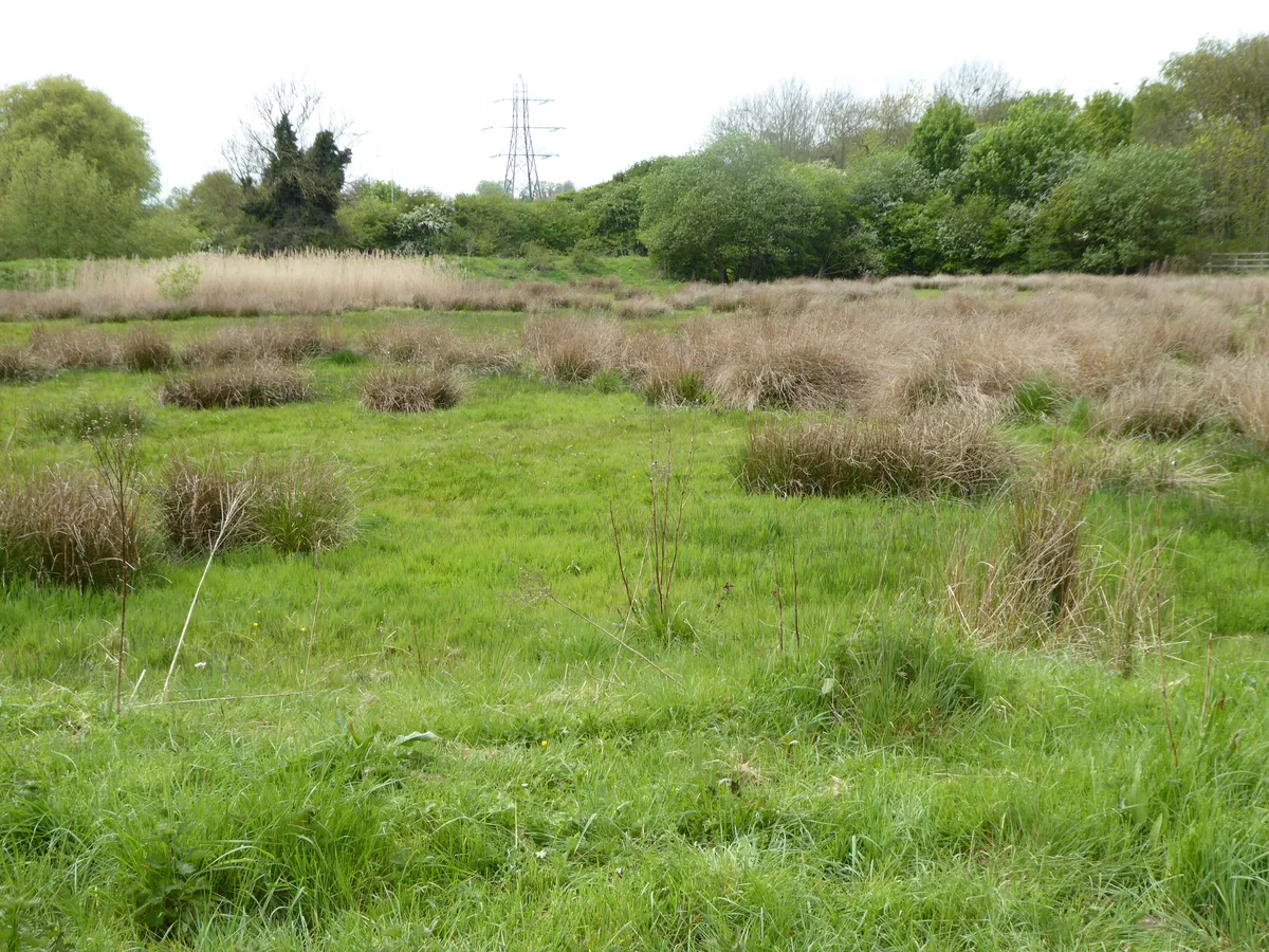
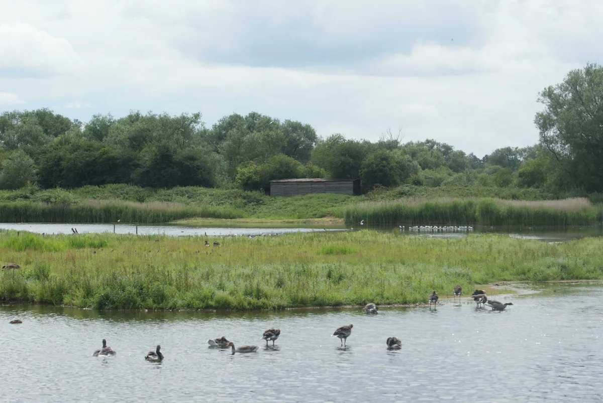
Upper Ray Meadows — nature reserve in Buckinghamshire, England.

Wikimedia Commons licence
Plan your visit
- Typical visit
- 2 h–4 h
- Best time of year
- Autumn & winter (migration & wildfowl)
- Nearest railway station
- Quainton Road · 7.0 km
- Free entry
- Dog-friendly
About
Upper Ray Meadows is a wildlife reserve in the United Kingdom. Wikidata describes it as: "nature reserve in Buckinghamshire, England". Coordinates: 51.8750°, -1.0289°.
Photo gallery
Protected designations
- Area of Outstanding Natural Beauty: Chilterns
Designations sourced from Natural England open data under OGL v3.
From the Wikipedia article
Upper Ray Meadows is a 181-hectare nature reserve, managed by the Berkshire, Buckinghamshire and Oxfordshire Wildlife Trust, south of Marsh Gibbon in Buckinghamshire. It is composed of a number of areas, one of which, Long Herdon Meadow, is a biological Site of Special Scientific Interest. The site consists of meadows on the floodplain of the River Ray, and it is a stronghold for rare species because heavy clay soils and frequent flooding makes arable farming difficult. The meadows are managed by traditional farming methods, and areas of medieval ridge and furrow still survive. In the summer, drier areas have displays of wild flowers such as black knapweed, meadowsweet and tufted vetch. The site supports a small breeding population of lapwings and curlews, and the Trust has created many new ponds and ditches to assist birds and invertebrates. Gallows Bridge Farm, which only has access to bird hides, is accessed from The Broadway. The Bernwood Jubilee Way between Marsh Gibbon and the A41 road runs along eastern boundary of Long Herdon Meadow, and there is an entrance where the footpath crosses the River Ray. Grange Meadow is accessed from Long Herdon Meadow. Bernwood Jubilee Way crosses the A41 and goes through Leaches Farm.
Excerpt from Wikipedia under CC BY-SA 4.0. See the source article linked in Sources below.
- Coordinates
- 51.8750, -1.0289
- District
- Buckinghamshire
- Parish
- Grendon Underwood
- Postcode
- HP18 0SX
- Parliamentary constituency
- Mid Buckinghamshire
- Nearest railway station
- Quainton Road — 7 km
Sources
- wikidata: Q24993653 (CC0)
- wikipedia: Upper Ray Meadows (CC BY-SA 4.0)
Other places nearby
Loading nearby places…
Nearby
 📷 3
📷 3Memorials & monuments · West Midlands
Grendon Underwood War Memorial
Grendon Underwood War Memorial — Grade II listed building-listed memorial in england-west-midlands, United Kingdom.
 📷 3
📷 3Forests & woodlands · West Midlands
Upper Ray Meadows
Upper Ray Meadows is a forest or woodland in the United Kingdom.
Mar2006.jpg?width=1200) 📷 3
📷 3Towns & cities · West Midlands
Edgcott
Edgcott — village and civil parish in Buckinghamshire, UK.
 📷 3
📷 3Forests & woodlands · West Midlands
Upper Ray Meadows
Upper Ray Meadows is a forest or woodland in the United Kingdom.
 📷 3
📷 3Forests & woodlands · West Midlands
Cow Leys
Cow Leys is a forest or woodland in the United Kingdom.
 📷 5
📷 5Towns & cities · West Midlands
Marsh Gibbon
Marsh Gibbon — village and civil parish in Buckinghamshire, UK.
More places in this region
 Flagship📷 3
Wildlife reserves · West Midlands
Abington Meadows
Abington Meadows — nature reserve in the United Kingdom.
 📷 5
📷 5Wildlife reserves · West Midlands
Brandon Marsh
Brandon Marsh — nature reserve in the United Kingdom.
 📷 5
📷 5Wildlife reserves · West Midlands
Bugbrooke Meadows
Bugbrooke Meadows — nature reserve in the United Kingdom.
 📷 5
📷 5Wildlife reserves · West Midlands
Chorleywood Common
Chorleywood Common — nature reserve in Hertfordshire, England.
Frequently asked questions
- Where is Upper Ray Meadows?
- Upper Ray Meadows is in the West Midlands, United Kingdom (postcode HP18 0SX), in the parish of Grendon Underwood.
- Is Upper Ray Meadows a protected site?
- Yes — Upper Ray Meadows is part of the Chilterns National Landscape (AONB).
- Is Upper Ray Meadows free to visit?
- Yes, Upper Ray Meadows is free to enter.
- How do I get to Upper Ray Meadows?
- The nearest railway station is Quainton Road, about 7.0 km away. Drivers can navigate to postcode HP18 0SX.
- Are dogs allowed at Upper Ray Meadows?
- Most wildlife reserves allow dogs on lead only, with restrictions during ground-nesting bird season (March-July). Check signage at the reserve.