
Memorials & monuments · South West England
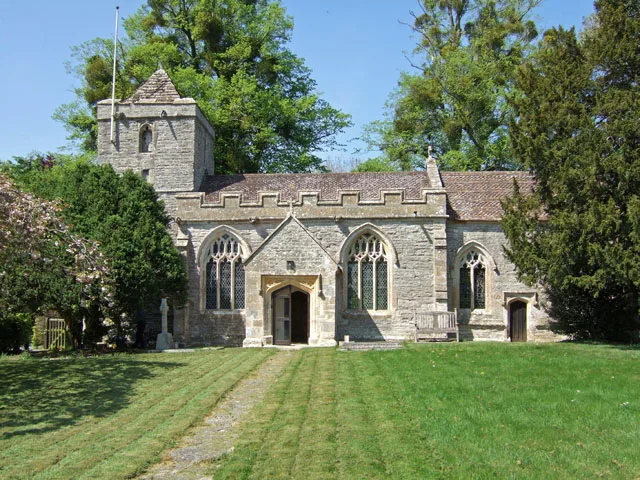
Unidentified Monument In Churchyard About 4 Metres South East Of Porch, Church Of St Thomas Of Canterbury
In or near South Barrow.
Unidentified Monument In Churchyard About 4 Metres South East Of Porch, Church Of St Thomas Of Canterbury — Grade II listed building-listed memorial in england-south-west, United Kingdom.

Trish Steel — CC BY-SA 2.0 via Wikimedia Commons licence

Plan your visit
- Typical visit
- 15 min–45 min
- Nearest railway station
- Castle Cary · 4.7 km
- Free entry
- Dog-friendly
Getting there & planning your visit
To visit the Unidentified Monument In Churchyard About 4 Metres South East Of Porch, Church Of St Thomas Of Canterbury, the nearest railway station is Castle Cary, located 4.7 km away. The postcode for navigation is BA7 7PY, and entry to the site is free.
About
Unidentified Monument In Churchyard About 4 Metres South East Of Porch, Church Of St Thomas Of Canterbury is a Grade II listed building-listed memorial in england-south-west, United Kingdom, registered on the National Heritage List for England (NHLE entry 1056529). Listed status protects buildings and structures of special architectural or historic interest. See the linked Wikipedia article for further details.
Photo gallery
Heritage listing
Details LOVINGTON CP ST53SE LOVINGTON VILLAGE 1/59 Unidentified monument in churchyard, about 4 m south-east of porch, Church of St Thomas of - Canterbury GV II Chest tomb. C18. Doulting and Keinton stone. Moulded plinth on slab base; plain ends and flanks of incised slab; much eroded; plain frieze, moulded coving to shallow hipped top. Inscriptions nearly all lost - the west end mentions Joyce Tid----, died possibly 1780. Listing NGR: ST5967430824 Legacy The contents of this record have been generated from a legacy data system. Legacy System number: 263384 Legacy System: LBS
From the Historic England List Entry under OGL v3.
Place summary
The Unidentified Monument in the churchyard, located about 4 metres south-east of the porch of the Church of St Thomas of Canterbury in Lovington, South-West England, is a Grade II listed building. It serves as a memorial, notable for its historical significance within the parish.
AI-generated from the structured facts on this page (operator, designation, listing, era). Not a substitute for visiting.
- Coordinates
- 51.0753, -2.5770
- District
- Somerset
- Parish
- Lovington
- Postcode
- BA7 7PY
- Parliamentary constituency
- Glastonbury and Somerton
- Nearest railway station
- Castle Cary — 4.7 km
Sources
- wikidata: Q26308260 (CC0)
Other places nearby

Alford, Somerset
Museums · 0.7 km

North Barrow
Villages · 1.6 km
Church of All Saints, Alford
Historic churches · 1.9 km

River Alham
Museums · 2.1 km

Medieval settlement 190m south west of Perry's Bridge
Vineyards · 2.2 km

East Lydford
Villages · 2.3 km

Church (Remains of)
Historic houses · 2.3 km

Bolter's Bridge
Historic bridges · 2.7 km

The Cross Keys Inn Caravan and Motorhome Park
Caravan parks · 3.0 km

South Barrow
Villages · 3.0 km

West Lydford
Villages · 3.3 km

Church of St Peter
Historic churches · 3.3 km
Nearby
📷 5Museums · South West England
Alford, Somerset
Alford is a village and parish on the River Alham, in Somerset, England, situated 8 miles (12.9 km) south of Shepton Mallet and two miles west of Castle Cary. The village has a population of 63.
📷 5📷 5Historic churches · South West England
Church of All Saints, Alford
Church of All Saints, Alford — church in Alford, Somerset, England, UK.
📷 5Museums · South West England
River Alham
The River Alham flows through Somerset, England. It rises at Higher Alham above Batcombe and runs through Alhampton, Milton Clevedon and joins the River Brue to the north of Alford. It was known as th
📷 5Vineyards · South West England
Medieval settlement 190m south west of Perry's Bridge
Medieval settlement 190m south west of Perry's Bridge — a UK vineyard in england south west, producing English or Welsh wine from cool-climate grape varieties.
📷 5Where to eat & stay near Unidentified Monument In Churchyard About 4 Metres South East Of Porch, Church Of St Thomas Of Canterbury
Places to stay
📷 5Caravan parks · South West England
The Cross Keys Inn Caravan and Motorhome Park
The Cross Keys Inn Caravan and Motorhome Park — a caravan park in england south west.
 📷 5
📷 5Campsites · South West England
Long Hazel Park
Long Hazel Park — a campsite in england south west.
 📷 5
📷 5Hotels · South West England
The George Hotel
The George Hotel — a hotel in england south west.
 📷 5
📷 5Campsites · South West England
Tall Trees Glamping
Tall Trees Glamping — a campsite in england south west.
 📷 5
📷 5 📷 5
📷 5Hotels · South West England
The Unicorn
The Unicorn — a hotel in england south west.
Places to eat & drink
📷 7 📷 7
📷 7Historic pubs · South West England
Manor House Inn
Manor House Inn in England South West, United Kingdom.
 📷 5
📷 5 📷 5
📷 5 📷 5
📷 5Restaurants · South West England
28 Market Place
28 Market Place — a restaurant in england south west.
 📷 5
📷 5More memorials in this region
 📷 5
📷 5Memorials & monuments · South West England
Bath Cenotaph
Bath Cenotaph is a memorial in the United Kingdom.
 📷 5
📷 5Memorials & monuments · South West England
Cross of Sacrifice
Cross of Sacrifice is a memorial in the United Kingdom.
 📷 5
📷 5Memorials & monuments · South West England
Grange Arch
Grange Arch is a memorial in the United Kingdom.
.jpg?width=1200) 📷 5
📷 5Memorials & monuments · South West England
King Alfred Memorial
King Alfred Memorial is a memorial in the United Kingdom.
Frequently asked questions
- Where is Unidentified Monument In Churchyard About 4 Metres South East Of Porch, Church Of St Thomas Of Canterbury?
- Unidentified Monument In Churchyard About 4 Metres South East Of Porch, Church Of St Thomas Of Canterbury is in South-West England, United Kingdom (postcode BA7 7PY), in the parish of Lovington.
- What is Unidentified Monument In Churchyard About 4 Metres South East Of Porch, Church Of St Thomas Of Canterbury?
- Unidentified Monument In Churchyard About 4 Metres South East Of Porch, Church Of St Thomas Of Canterbury — Grade II listed building-listed memorial in england-south-west, United Kingdom.
- How do I get to Unidentified Monument In Churchyard About 4 Metres South East Of Porch, Church Of St Thomas Of Canterbury?
- The nearest railway station is Castle Cary, about 4.7 km away. The nearest town is South Barrow. Drivers can use postcode BA7 7PY.
- Is Unidentified Monument In Churchyard About 4 Metres South East Of Porch, Church Of St Thomas Of Canterbury a listed building?
- Unidentified Monument In Churchyard About 4 Metres South East Of Porch, Church Of St Thomas Of Canterbury is officially recognised as Grade II listed building listed.
- Is Unidentified Monument In Churchyard About 4 Metres South East Of Porch, Church Of St Thomas Of Canterbury free to visit?
- Yes, Unidentified Monument In Churchyard About 4 Metres South East Of Porch, Church Of St Thomas Of Canterbury is free to enter.
- How do I get to Unidentified Monument In Churchyard About 4 Metres South East Of Porch, Church Of St Thomas Of Canterbury?
- The nearest railway station is Castle Cary, about 4.7 km away. Drivers can navigate to postcode BA7 7PY.