
Canals · North West England
Ulverston Canal
In or near Swarthmoor.
Ulverston Canal is a canal in the United Kingdom.

Wikimedia Commons contributors — see linked file page for photographer and licence licence

Plan your visit
- Typical visit
- 1 h–2 h
- Nearest railway station
- Ulverston · 1.8 km
- Free entry
- Dog-friendly
Getting there & planning your visit
To visit Ulverston Canal, you can take a train to Ulverston station, which is 1.8 km away. The postcode for navigation is LA12 9EA, and entry to the canal is free.
About
Ulverston Canal is a canal in the United Kingdom. Coordinates: 54.1942°, -3.0700°. This entry is part of The Great Britain Guide, a free, ad-free, open-data tourist directory.
Photo gallery
Protected designations
- Site of Special Scientific Interest: Morecambe Bay SSSI
- Ramsar wetland: Morecambe Bay
Designations sourced from Natural England open data under OGL v3.
From the Wikipedia article
The Ulverston Canal is a 1.25-mile (2 km) ship canal that connects the town of Ulverston, Cumbria, England with Morecambe Bay. The waterway, which is entirely straight and on a single level, is isolated from the rest of the UK canal network. It was built so that maritime trading vessels could use the town's port. Ulverston Canal was built in the late 18th century. Wharves were built in the town to handle the cargo and goods being loaded and unloaded from seagoing vessels. The canal promoted the industrial development of Ulverston. Despite its loss of economic importance with the construction of the Furness Railway in the mid 19th century, the canal remained in commercial operation until the 1940s when it was eventually abandoned. The canal's preservation is now managed by a property management company that receives funding from GlaxoSmithKline, which has a plant adjacent to the canal. The canal runs between its former sea entrance, known as Canal Foot, at Hammerside Point on Morecambe Bay and its basin and wharves at Ulverston. The 112-foot-long (34 m) sea lock was the only lock on the canal; however, the lock has been sealed with a concrete dam and footbridge. Beside the canal is a sheep and cattle auction and several waterside buildings have been renovated. At its mouth, the Bay Horse Hotel stands on the site of an 18th-century coaching inn; the Cumbria Coastal Way crosses the canal at this point.
Excerpt from Wikipedia under CC BY-SA 4.0. See the source article linked in Sources below.
Background
Architecture
Although it is about 1.25 mi from the River Leven estuary which is part of Morecambe Bay, the town of Ulverston was declared to be a port in 1774, which allowed goods to be shipped to other canals without the payment of sea duty. Ships of up to 150 tonnes could reach the shore at high water, and 70 vessels were registered there. Trade in slate and ore was growing, and canal mania was gripping the country. A local solicitor, William Burnthwaite. organised a meeting in July 1791 to consider ideas for a canal to improve access to the town. He estimated the cost at £2,000. This sum had been raised by May 1792, but by then the engineer John Rennie had produced proper plans for a ship canal,…
Sourced from Wikipedia under CC BY-SA 4.0.
- Coordinates
- 54.1942, -3.0700
- District
- Westmorland and Furness
- Parish
- Ulverston
- Postcode
- LA12 9EA
- Parliamentary constituency
- Barrow and Furness
- Established
- 1796
- Nearest railway station
- Ulverston — 1.8 km
Sources
- wikidata: Q7880849 (CC0)
- wikipedia: Ulverston Canal (CC BY-SA 4.0)
- commons: Canal Foot Ulverston.JPG (CC BY-SA 4.0)
Other places nearby

Rolling Bridge Over Ulverston Canal And Associated Accumulator Tower
Historic bridges · 0.1 km

Shed One
Distilleries · 0.9 km

Ulverston Auction Mart
Farmers’ markets · 1.0 km

The Wall
Indoor climbing centres · 1.1 km
.jpg?width=1200)
Plumpton Hall
Historic houses · 1.2 km

Hoad Hill
Mountains & hills · 1.2 km

Sir John Barrow Monument
Memorials & monuments · 1.2 km

Ulverston
Museums · 1.3 km

Lightburn Park Railway
Heritage railways · 1.3 km

Sir John Barrow Cottage
Museums · 1.4 km
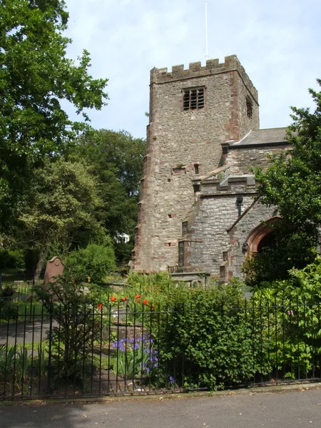
St Mary's Church, Ulverston
Historic churches · 1.5 km

Oddfellows Hall
Memorials & monuments · 1.5 km
Nearby
📷 4Historic bridges · North West England
Rolling Bridge Over Ulverston Canal And Associated Accumulator Tower
Rolling Bridge Over Ulverston Canal And Associated Accumulator Tower — Grade II listed building-listed bridge in england-north-west, United Kingdom.
📷 3Distilleries · North West England
Shed One
Shed One — Whisky/spirit distillery.
📷 5Farmers’ markets · North West England
Ulverston Auction Mart
Ulverston Auction Mart — a UK farmers' market in england north west.
📷 3Indoor climbing centres · North West England
The Wall
The Wall — a indoor climbing in england-north-west, United Kingdom.
📷 3Historic houses · North West England
Plumpton Hall
Plumpton Hall — house in Egton with Newland, South Lakeland, England, UK.
📷 5Mountains & hills · North West England
Hoad Hill
Hoad Hill — mountain in england north west. Elevation: 133 m.
Where to eat & stay near Ulverston Canal
Places to stay
 📷 5
📷 5B&Bs · North West England
Town House B&B
Town House B&B — a bed-and-breakfast in england north west.
📷 5B&Bs · North West England
Sefton House
Sefton House — a bed-and-breakfast in england north west.
 📷 5
📷 5Hotels · North West England
Lonsdale House Hotel
Lonsdale House Hotel — a hotel in england north west.
 📷 5
📷 5Caravan parks · North West England
Bardsea Leisure Park
Bardsea Leisure Park — a caravan park in england north west.
 📷 5
📷 5Hotels · North West England
Swarthmoor Hall
Swarthmoor Hall — a hotel in england north west.
 📷 5
📷 5Caravan parks · North West England
Old Park Wood
Old Park Wood — a caravan park in england north west.
Places to eat & drink
 📷 5
📷 5Historic pubs · North West England
Hoppers Public House
Hoppers Public House in England North West, United Kingdom.
 📷 4
📷 4Restaurants · North West England
L'Enclume
L'Enclume (pronounced [lɑ̃.klym], French for "the anvil") is a Modern British restaurant opened in 2002 in Cartmel, Cumbria, England, run by the chef Simon Rogan and his partner, Penny Tapsell. L'Encl
 📷 5
📷 5Restaurants · North West England
L'Enclume
L'Enclume — a restaurant in england north west.
 📷 5
📷 5Historic pubs · North West England
Chappells Tavern
Chappells Tavern in England North West, United Kingdom.
 📷 5
📷 5Historic pubs · North West England
Furness Abbey Hotel
Furness Abbey Hotel in England North West, United Kingdom.
 📷 7
📷 7More places in this region
 📷 5
📷 5Canals · North West England
Bridgewater Canal
Bridgewater Canal — canal in North West England.
 📷 4
📷 4 📷 3
📷 3Canals · North West England
Hulme Lock Branch Canal
Hulme Lock Branch Canal — Grade II listed canal in Manchester, Greater Manchester, England, UK.
 📷 5
📷 5Canals · North West England
Hulme Locks Branch Canal
Hulme Locks Branch Canal — canal in Manchester, England.
Frequently asked questions
- Where is Ulverston Canal?
- Ulverston Canal is in North-West England, United Kingdom (postcode LA12 9EA), in the parish of Ulverston.
- What is Ulverston Canal?
- Ulverston Canal is a canal in the United Kingdom.
- How do I get to Ulverston Canal?
- The nearest railway station is Ulverston, about 1.8 km away. The nearest town is Swarthmoor. Drivers can use postcode LA12 9EA.
- When was Ulverston Canal built?
- Built or established in 1796.
- Is Ulverston Canal a protected site?
- Yes — Ulverston Canal is part of the Morecambe Bay SSSI Site of Special Scientific Interest and the Morecambe Bay Ramsar wetland.
- Is Ulverston Canal free to visit?
- Yes, Ulverston Canal is free to enter.
- How do I get to Ulverston Canal?
- The nearest railway station is Ulverston, about 1.8 km away. Drivers can navigate to postcode LA12 9EA.