
Archaeological sites · South West England
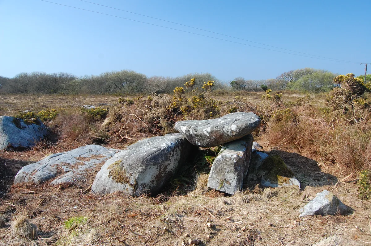
Two standing stones on Crousa Common, 890m WSW of Chywoone
In or near St Martin-in-Meneage.
Two standing stones on Crousa Common, 890m WSW of Chywoone — archaeological site in St Keverne, Cornwall, England, UK.

Wikimedia Commons contributors — see linked file page for photographer and licence licence

Plan your visit
- Typical visit
- 45 min–1.5 h
- Free entry
- Dog-friendly
About
Two standing stones on Crousa Common, 890m WSW of Chywoone is an archaeological site in the United Kingdom. Heritage designation: scheduled monument. Wikidata describes it as: "archaeological site in St Keverne, Cornwall, England, UK". Coordinates: 50.0393°, -5.1084°.
Photo gallery
Protected designations
- Site of Special Scientific Interest: East Lizard Heathlands SSSI
- National Nature Reserve: THE LIZARD
- Area of Outstanding Natural Beauty: Cornwall
Designations sourced from Natural England open data under OGL v3.
Place summary
Two standing stones on Crousa Common, located 890m WSW of Chywoone in South-West England, are designated as a scheduled monument. The site is situated within the East Lizard Heathlands SSSI, part of the Lizard National Nature Reserve and the Cornwall Area of Outstanding Natural Beauty.
AI-generated from the structured facts on this page (operator, designation, listing, era). Not a substitute for visiting.
- Coordinates
- 50.0393, -5.1084
- District
- Cornwall
- Parish
- St. Keverne
- Postcode
- TR12 6RD
- Parliamentary constituency
- St Ives
Sources
- wikidata: Q17640674 (CC0)
- commons: Crousa Common Standing Stones - geograph.org.uk - 940224.jpg (CC BY-SA 4.0)
Other places nearby

Standing stone known as the Long Stone, 200m north east of Tremenheere
Windmills · 1.0 km
Q84738501
Windmills · 1.0 km
Portal dolmen known as 'The Three Brothers of Grugith'
Archaeological sites · 1.4 km

The Three Brothers of Crugith
Archaeological sites · 1.4 km

Saint Keverne
Villages · 1.8 km

Coverack
Villages · 1.8 km

St Keverne
Historic churches · 1.8 km

Church of St Akeveranus
Historic churches · 2.0 km

Maple Leaf Farm Caravan and Camper Van Site
Campsites · 2.0 km

Penmarth Farm Campsite
Campsites · 2.1 km

Coverack Watersports Centre (Windsurfing, Kayaks & SUPs)
Natural landmarks · 2.1 km

YHA Coverack
Hostels · 2.1 km
Nearby
📷 5Windmills · South West England
Standing stone known as the Long Stone, 200m north east of Tremenheere
Standing stone known as the Long Stone, 200m north east of Tremenheere — a post mill in england-south-west, United Kingdom.
📷 5Windmills · South West England
Q84738501
Q84738501 — a post mill in england-south-west, United Kingdom.
📷 5Archaeological sites · South West England
Portal dolmen known as 'The Three Brothers of Grugith'
Portal dolmen known as 'The Three Brothers of Grugith' — archaeological site in Cornwall, England, UK.
📷 3Archaeological sites · South West England
The Three Brothers of Crugith
The Three Brothers of Crugith — a archaeological in england-south-west, United Kingdom.
📷 5📷 5Where to eat & stay near Two standing stones on Crousa Common, 890m WSW of Chywoone
Places to stay
📷 5Campsites · South West England
Maple Leaf Farm Caravan and Camper Van Site
Maple Leaf Farm Caravan and Camper Van Site — a campsite in england south west.
📷 5Campsites · South West England
Penmarth Farm Campsite
Penmarth Farm Campsite — a campsite in england south west.
📷 5 📷 5
📷 5Campsites · South West England
YHA Coverack campsite
YHA Coverack campsite — a campsite in england south west.
📷 5Campsites · South West England
Heath Farm Camping
Heath Farm Camping — a campsite in england south west.
 📷 5
📷 5Campsites · South West England
Little Trevothan Caravan and Camping Park
Little Trevothan Caravan and Camping Park — a campsite in england south west.
Places to eat & drink
 📷 5
📷 5Restaurants · South West England
Ming's Garden
Ming's Garden — a restaurant in england south west.
 📷 6
📷 6Historic pubs · South West England
Seven Stars, Falmouth
Seven Stars, Falmouth in England South West, United Kingdom.
 📷 5
📷 5Historic pubs · South West England
The Kimberley Public House
The Kimberley Public House in England South West, United Kingdom.
 📷 5
📷 5Historic pubs · South West England
Fitzsimmons Arms Public House
Fitzsimmons Arms Public House in England South West, United Kingdom.
 📷 5
📷 5Historic pubs · South West England
The Famous Barrel Public House
The Famous Barrel Public House in England South West, United Kingdom.
 📷 5
📷 5Historic pubs · South West England
Kings Arms
Kings Arms — Historic pub — listed building or notable heritage status.
More archaeological sites in this region
 📷 5
📷 5Archaeological sites · South West England
Battlesbury Camp Monuments: hillfort, settlement, cemetery, barrows, enclosure, and field systems
Battlesbury Camp Monuments: hillfort, settlement, cemetery, barrows, enclosure, and field systems — archaeological site in Warminster, Wiltshire, England, UK.
 📷 2
📷 2Archaeological sites · South West England
Blandford Forest
Blandford Forest — forest in Blandford Forum, England.
 📷 5
📷 5Archaeological sites · South West England
Boulsbury Wood
Boulsbury Wood — protected area in Dorset and Hampshire, England.
.jpg?width=1200) 📷 5
📷 5Archaeological sites · South West England
Cranborne Chase
Cranborne Chase — Plateau in southern England.
Frequently asked questions
- Where is Two standing stones on Crousa Common, 890m WSW of Chywoone?
- Two standing stones on Crousa Common, 890m WSW of Chywoone is in South-West England, United Kingdom (postcode TR12 6RD), in the parish of St. Keverne.
- What is Two standing stones on Crousa Common, 890m WSW of Chywoone?
- Two standing stones on Crousa Common, 890m WSW of Chywoone — archaeological site in St Keverne, Cornwall, England, UK.
- How do I get to Two standing stones on Crousa Common, 890m WSW of Chywoone?
- Drivers can use postcode TR12 6RD.
- Is Two standing stones on Crousa Common, 890m WSW of Chywoone a listed building?
- Two standing stones on Crousa Common, 890m WSW of Chywoone is officially recognised as scheduled monument listed.
- Is Two standing stones on Crousa Common, 890m WSW of Chywoone a protected site?
- Yes — Two standing stones on Crousa Common, 890m WSW of Chywoone is part of the East Lizard Heathlands SSSI Site of Special Scientific Interest and the THE LIZARD National Nature Reserve.
- Is Two standing stones on Crousa Common, 890m WSW of Chywoone free to visit?
- Yes, Two standing stones on Crousa Common, 890m WSW of Chywoone is free to enter.
- How do I get to Two standing stones on Crousa Common, 890m WSW of Chywoone?
- Drivers can navigate to postcode TR12 6RD. It sits within the St Ives parliamentary constituency.