
Memorials & monuments · South East England
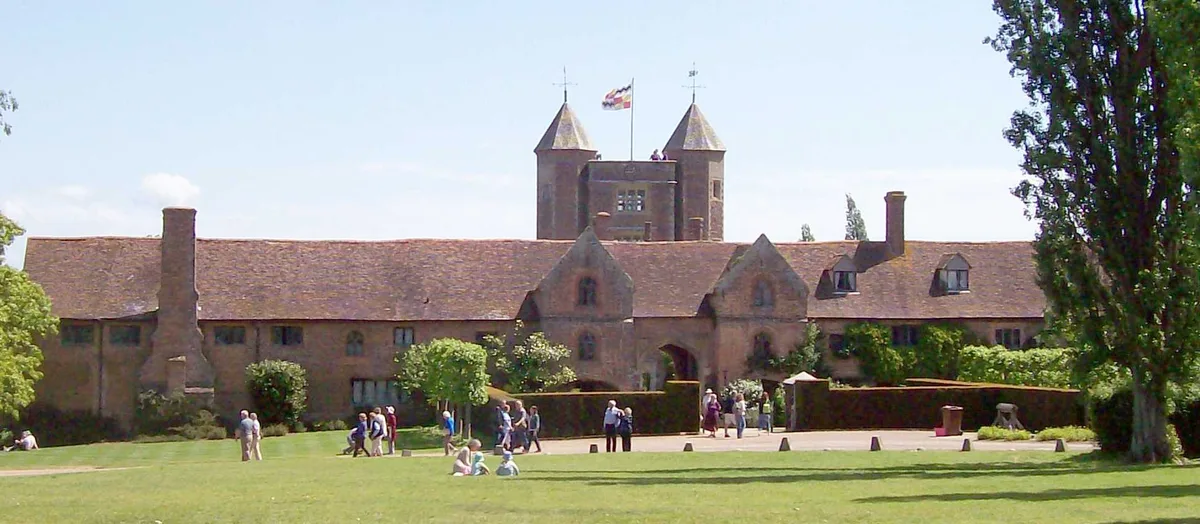
Tower and walls 30 yards east of the West Range at Sissinghurst Castle
In or near Frittenden.
Tower and walls 30 yards east of the West Range at Sissinghurst Castle — Grade I listed building-listed memorial in england-south-east, United Kingdom.

Pete Chapman — CC BY-SA 2.0 via Wikimedia Commons licence

Plan your visit
- Typical visit
- 15 min–45 min
- Nearest railway station
- Headcorn · 6.4 km
- Free entry
- Family-friendly
- Dog-friendly
- Limited wheelchair access
Getting there & planning your visit
The nearest railway station is Headcorn, located 6.4 km away. Entry to the Tower and walls is free, but wheelchair accessibility is limited. The postcode for sat-nav is TN17 2AB.
About
Tower and walls 30 yards east of the West Range at Sissinghurst Castle is a Grade I listed building-listed memorial in england-south-east, United Kingdom, registered on the National Heritage List for England (NHLE entry 1084163). Listed status protects buildings and structures of special architectural or historic interest. See the linked Wikipedia article for further details.
Photo gallery
See it from the streetimagery from 2019
Imagery © Mapillary contributors, CC BY-SA 4.0
Heritage listing
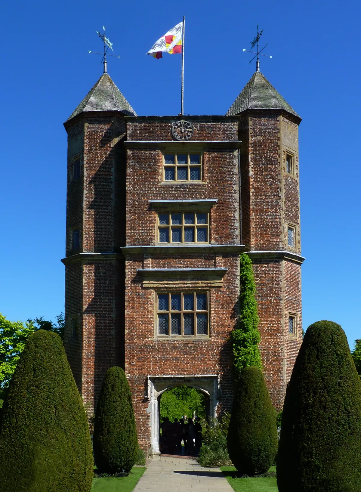
Details CRANBROOK BIDDENDEN ROAD TQ 83 NW (NORTH SIDE) 4/27 Sissinghurst 9.6.52 Tower and Walls 30 yards east of the west range at Sissinghurst Castle (formerly listed as part of Sissinghurst Castle) GV I Tower and walls. Circa 1570 for Sir Richard Baker. Red brick with red brick, stone and some cemented dressings, and bands between first and second and over third floors in centre. Coped parapet in centre and modillion cornices to shingled roofs with weather-vanes over towers. Central rectangular tower with flanking octagonal stair-turrets, that to north only containing staircase. Four storeys in centre with 3 windows on east and west sides of each stain- turret. Six-light transom and mullion window on third floor of centre, 8-light window on second floor with drip-mould over and large 8-light window in pilastered surround with entablature over on first floor. Bases of first floor pilasters rest directly on top of entablature and pilasters of the round-arched entrance surround. To north and south of the tower the remains of the enclosing walls of the courtyard, about 25 yards long, of the circa 1570 house extend, that to the south returning to the west some 40 yards, and including the remains of windows and a doorway. These have been rebuilt but rest on earlier parts below. Vita Sackville-West customarily wrote in the first floor room of the tower. Listing NGR: TQ8084338316 Legacy The contents of this record have been generated from a legacy data system. Legacy System number: 168878 Legacy System: LBS
From the Historic England List Entry under OGL v3.
Protected designations
- Area of Outstanding Natural Beauty: High Weald
- Area of Outstanding Natural Beauty: Kent Downs
Designations sourced from Natural England open data under OGL v3.
Place summary
The Tower and walls 30 yards east of the West Range at Sissinghurst Castle is a Grade I listed memorial located in Kent, South-East England. Situated within the parish of Cranbrook & Sissinghurst, it is notable for its historical significance and architectural integrity.
AI-generated from the structured facts on this page (operator, designation, listing, era). Not a substitute for visiting.
- Coordinates
- 51.1156, 0.5818
- County
- Kent
- District
- Tunbridge Wells
- Parish
- Cranbrook & Sissinghurst
- Postcode
- TN17 2AB
- Parliamentary constituency
- Weald of Kent
- Nearest railway station
- Headcorn — 6.4 km
- Official site
- www.nationaltrust.org.uk
Sources
- wikidata: Q17530338 (CC0)
Other places nearby

West Range at Sissinghurst Castle
Castles · 0.0 km
Sissinghurst Castle
Castles · 0.0 km

Sissinghurst Castle and Garden
Castles · 0.0 km
Sissinghurst Castle Garden
Gardens · 0.3 km
.jpg?width=1200)
King's Head House
Historic houses · 1.7 km

Sissinghurst
Villages · 1.7 km

Hayselden Manor
Manor houses · 1.9 km

Plush Huts
Campsites · 2.6 km

Monument To Reverend Edward Moore, About 25 Metres South Of Church Of St Mary
Memorials & monuments · 2.7 km
Apr2006.jpg?width=1200)
Frittenden
Towns & cities · 3.0 km

Coursehorn
Towns & cities · 3.0 km

Old Wilsley
Historic houses · 3.1 km
Nearby
📷 5Castles · South East England
West Range at Sissinghurst Castle
West Range at Sissinghurst Castle — a Grade I-listed castle in england-south-east, United Kingdom.
📷 5Castles · South East England
Sissinghurst Castle
Sissinghurst Castle — castle in Kent, England.
📷 5Castles · South East England
Sissinghurst Castle and Garden
Sissinghurst Castle and Garden — a castle in england-south-east, United Kingdom.
★ Iconic📷 10Gardens · South East England
Sissinghurst Castle Garden
Vita Sackville-West's 1930s garden in Kent — the most-imitated White Garden in Britain.
📷 5Historic houses · South East England
King's Head House
King's Head House — house in Cranbrook & Sissinghurst, Tunbridge Wells, England, UK.
📷 5Where to eat & stay near Tower and walls 30 yards east of the West Range at Sissinghurst Castle
Places to stay
📷 5 📷 5
📷 5Caravan parks · South East England
Waterside Oast
Waterside Oast — a caravan park in england south east.
 📷 5
📷 5Campsites · South East England
Star Field camping and glamping
Star Field camping and glamping — a campsite in england south east.
 📷 5
📷 5 📷 5
📷 5Campsites · South East England
Glassenbury Camping
Glassenbury Camping — a campsite in england south east.
 📷 5
📷 5Places to eat & drink
 📷 7
📷 7Restaurants · South East England
West House
West House — a restaurant in england south east.
 📷 7
📷 7Historic pubs · South East England
The Kings Arms Inn And Shop Adjoining To Right
The Kings Arms Inn And Shop Adjoining To Right in England South East, United Kingdom.
 📷 7
📷 7Historic pubs · South East England
The Gun And Spitroast Public House And Rear Courtyard
The Gun And Spitroast Public House And Rear Courtyard in England South East, United Kingdom.
 📷 5
📷 5Historic pubs · South East England
The Harrow Public House
The Harrow Public House in England South East, United Kingdom.
 📷 5
📷 5Historic pubs · South East England
The George Public House
The George Public House in England South East, United Kingdom.
 📷 7
📷 7More memorials in this region
 📷 5
📷 5Memorials & monuments · South East England
Air Forces Memorial
Air Forces Memorial is a memorial in the United Kingdom.
 📷 5
📷 5Memorials & monuments · South East England
All Saints Church
All Saints Church is a memorial in the United Kingdom.
 📷 5
📷 5Memorials & monuments · South East England
Bevans War Memorial
Bevans War Memorial is a memorial in the United Kingdom.
.jpg?width=1200) 📷 5
📷 5Memorials & monuments · South East England
Cumberland Obelisk
Cumberland Obelisk is a memorial in the United Kingdom.
Frequently asked questions
- Where is Tower and walls 30 yards east of the West Range at Sissinghurst Castle?
- Tower and walls 30 yards east of the West Range at Sissinghurst Castle is in Kent, South-East England, United Kingdom (postcode TN17 2AB), in the parish of Cranbrook & Sissinghurst.
- What is Tower and walls 30 yards east of the West Range at Sissinghurst Castle?
- Tower and walls 30 yards east of the West Range at Sissinghurst Castle — Grade I listed building-listed memorial in england-south-east, United Kingdom.
- How do I get to Tower and walls 30 yards east of the West Range at Sissinghurst Castle?
- The nearest railway station is Headcorn, about 6.4 km away. Drivers can use postcode TN17 2AB.
- Is Tower and walls 30 yards east of the West Range at Sissinghurst Castle a listed building?
- Tower and walls 30 yards east of the West Range at Sissinghurst Castle is officially recognised as Grade I listed building listed.
- Is Tower and walls 30 yards east of the West Range at Sissinghurst Castle a protected site?
- Yes — Tower and walls 30 yards east of the West Range at Sissinghurst Castle is part of the High Weald National Landscape (AONB) and the Kent Downs National Landscape (AONB).
- Is Tower and walls 30 yards east of the West Range at Sissinghurst Castle free to visit?
- Yes, Tower and walls 30 yards east of the West Range at Sissinghurst Castle is free to enter.
- How do I get to Tower and walls 30 yards east of the West Range at Sissinghurst Castle?
- The nearest railway station is Headcorn, about 6.4 km away. Drivers can navigate to postcode TN17 2AB.