
Forests & woodlands · East of England
Tollesbury Wick Marshes
In or near Virley.
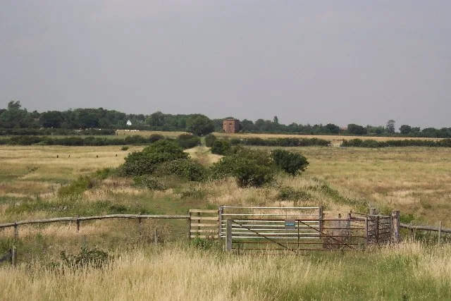
Tollesbury Wick Marshes is a forest or woodland in the United Kingdom.

Wikimedia Commons contributors — see linked file page for photographer and licence licence

Plan your visit
- Typical visit
- 1 h–3 h
- Free entry
- Family-friendly
- Dog-friendly
About
Tollesbury Wick Marshes is a named forest, woodland or nature reserve in the United Kingdom. Coordinates: 51.7534°, 0.8640°. This entry is part of The Great Britain Guide, a free, ad-free, open-data tourist directory.
Photo gallery
Protected designations
- Site of Special Scientific Interest: Blackwater Estuary SSSI
- National Nature Reserve: BLACKWATER ESTUARY
- Ramsar wetland: Blackwater Estuary (Mid-Essex Coast Phase 4)
Designations sourced from Natural England open data under OGL v3.
From the Wikipedia article
Tollesbury Wick is a 242.8-hectare (600-acre) nature reserve east of Tollesbury in Essex. It is managed by the Essex Wildlife Trust. Tollesbury Wick Marshes is part of the Blackwater Estuary Site of Special Scientific Interest. This area is coastal freshwater marsh, which is grazed by sheep. It is worked by traditional methods that encourage wildlife. Areas of ungrazed rough pasture have badgers, and field voles and pygmy shrews are hunted by hen harriers and short-eared owls. The shore of the marshes is within the Blackwater, Crouch, Roach and Colne Estuaries Marine Conservation Zone. There is access from the sea wall only to a footpath to a bird hide.
Excerpt from Wikipedia under CC BY-SA 4.0. See the source article linked in Sources below.
Background
History
The marshes were once part of a salt production industry during the Iron Age and Roman periods, and red hills created by this process are found across the area. Tollesbury Pier railway station was to the south-west of the marsh, the southern extension of the Kelvedon and Tollesbury Light Railway, offering a passenger service from 1907 to 1921. The anticipated development of housing and yachting facilities near the station never materialised. The Essex Wildlife Trust acquired the area in the 1990s. Previously the area was highly drained flat arable and rough set-aside farmland, with little wildlife. The trust allowed water to collect in the area, but the land had drainage problems and also…
Sourced from Wikipedia under CC BY-SA 4.0.
- Coordinates
- 51.7534, 0.8640
- County
- Essex
- District
- Maldon
- Parish
- Tollesbury
- Postcode
- CM9 8TB
- Parliamentary constituency
- Witham
Sources
- osm: r1555352 (ODbL)
- wikipedia: Tollesbury Wick (CC BY-SA 4.0)
- commons: The site of Tollesbury Pier railway station - geograph.org.uk - 40324.jpg (CC BY-SA 4.0)
Other places nearby
Tollesbury Wick
Wildlife reserves · 0.9 km

Lightship
Natural landmarks · 1.0 km

Woodup Amenity Pool
Lidos & outdoor pools · 1.2 km

Great Cob Island
Islands · 1.4 km

Tollesbury
Villages · 2.1 km

Radio Caroline Ross Revenge
Museums · 2.1 km

The King's Head Public House
Historic pubs · 2.2 km

Cobmarsh Island
Islands · 3.2 km

RAF Bradwell Bay memorial
Memorials & monuments · 3.4 km

Virley
Towns & cities · 3.9 km

Bradwell-On-Sea War Memorial
Memorials & monuments · 4.1 km

Weymarks Beach
Beaches · 4.1 km
Nearby
Flagship📷 5Wildlife reserves · East of England
Tollesbury Wick
Tollesbury Wick — Essex Wildlife Trust Nature reserve.
📷 3Natural landmarks · East of England
Lightship
Lightship — a other in england-east, United Kingdom.
📷 5Lidos & outdoor pools · East of England
Woodup Amenity Pool
Woodup Amenity Pool — a lido in england east.
📷 3📷 5📷 3Museums · East of England
Radio Caroline Ross Revenge
Radio Caroline Ross Revenge — a museum in england-east, United Kingdom.
Where to eat & stay near Tollesbury Wick Marshes
Places to stay
 📷 5
📷 5Caravan parks · East of England
St Lawrence Holiday Park
St Lawrence Holiday Park — a caravan park in england east.
 📷 5
📷 5Caravan parks · East of England
Waterside Holiday Park
Waterside Holiday Park — a caravan park in england east.
 📷 5
📷 5 📷 5
📷 5 📷 5
📷 5Caravan parks · East of England
Steeple Bay Holiday Park
Steeple Bay Holiday Park — a caravan park in england east.
 📷 5
📷 5Caravan parks · East of England
Coopers Beach Holiday Park
Coopers Beach Holiday Park — a caravan park in england east. Brand: Parkdean Resorts.
Places to eat & drink
📷 5Historic pubs · East of England
The King's Head Public House
The King's Head Public House in England East, United Kingdom.
 📷 5
📷 5Historic pubs · East of England
The Fox And Hounds
The Fox And Hounds in England East, United Kingdom.
 📷 7
📷 7Historic pubs · East of England
Peldon Rose Public House
Peldon Rose Public House in England East, United Kingdom.
 📷 7
📷 7Historic pubs · East of England
Dog And Pheasant Public House
Dog And Pheasant Public House in England East, United Kingdom.
 📷 5
📷 5Historic pubs · East of England
The Mayland Mill Public House
The Mayland Mill Public House in England East, United Kingdom.
 📷 7
📷 7Historic pubs · East of England
Donkey And Buskins Public House
Donkey And Buskins Public House in England East, United Kingdom.
More forests in this region
 📷 5
📷 5Forests & woodlands · East of England
Adams Road Bird Sanctuary
Adams Road Bird Sanctuary is a forest or woodland in the United Kingdom.
 📷 5
📷 5Forests & woodlands · East of England
Arthur's Meadow NR
Arthur's Meadow NR is a forest or woodland in the United Kingdom.
 📷 5
📷 5Forests & woodlands · East of England
Ashwell Quarry & Quarry Springs
Ashwell Quarry & Quarry Springs is a forest or woodland in the United Kingdom.
 📷 5
📷 5Forests & woodlands · East of England
Ashwell Springs
Ashwell Springs is a forest or woodland in the United Kingdom.
Frequently asked questions
- Where is Tollesbury Wick Marshes?
- Tollesbury Wick Marshes is in Essex, East of England, United Kingdom (postcode CM9 8TB), in the parish of Tollesbury.
- What is Tollesbury Wick Marshes?
- Tollesbury Wick Marshes is a forest or woodland in the United Kingdom.
- How do I get to Tollesbury Wick Marshes?
- Drivers can use postcode CM9 8TB.
- Who owns Tollesbury Wick Marshes?
- Tollesbury Wick Marshes is owned by Essex Wildlife Trust.
- Is Tollesbury Wick Marshes a protected site?
- Yes — Tollesbury Wick Marshes is part of the Blackwater Estuary SSSI Site of Special Scientific Interest and the BLACKWATER ESTUARY National Nature Reserve.
- Is Tollesbury Wick Marshes free to visit?
- Yes, Tollesbury Wick Marshes is free to enter.
- How do I get to Tollesbury Wick Marshes?
- Drivers can navigate to postcode CM9 8TB. It sits within the Witham parliamentary constituency.