Islands · Central Scotland
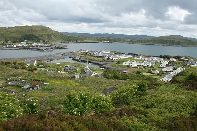
Tighnabruaich
Also known as: Taigh na Bruaich
In or near Port Bannatyne.
Tighnabruaich in Inner Hebrides + Skye, United Kingdom.

Johnny Durnan — CC BY-SA 2.0 via Wikimedia Commons licence
Plan your visit
- Typical visit
- 4 h–12 h
- Free entry
- Dog-friendly
About
Tighnabruaich is a place of interest in Inner Hebrides + Skye, United Kingdom — drawn from open-data sources for visitor reference. See the linked Wikipedia article for the full description.
Photo gallery
See it from the streetimagery from 2023
Imagery © Mapillary contributors, CC BY-SA 4.0
From the Wikipedia article
Tighnabruaich ( ; Scottish Gaelic: Taigh na Bruaich) is a village on the Cowal Peninsula, on the western arm of the Kyles of Bute in Argyll and Bute, west of Scotland. In 2011 the population was 660. It is west of Glasgow and north of the Isle of Arran. Tighnabruaich is Gaelic for "house of the bank". Tighnabruaich is now part of a continuous coastal strip of housing that joins onto Kames.
Excerpt from Wikipedia under CC BY-SA 4.0. See the source article linked in Sources below.
Background
History
A pier was possibly built in the 1830s by the Castle Steamship Company, a forerunner of Caledonian MacBrayne. It was a stopping place for paddle steamers and Clyde puffers. The wooden pier was rebuilt in 1885 by the Tighnabruaich Estate who owned it from 1840 until 1950. George Olding owned it until 1965 when it became the responsibility of the local council. Passenger services on and around the Clyde were developed after the PS Comet was introduced into service in 1812 and tourism developed with the introduction of cruises through the Kyles around Bute, to Arran and along Loch Fyne. [2025, currently under new ownership and closed for extensive renovations.]
Sourced from Wikipedia under CC BY-SA 4.0.
- Coordinates
- 55.9075, -5.2347
- District
- Argyll and Bute
- Postcode
- PA21 2DS
- Parliamentary constituency
- Argyll, Bute and South Lochaber
Sources
- wikidata: Q7801613 (CC0)
- wikipedia: Tighnabruaich (CC BY-SA 4.0)
Other places nearby

Parish Church, Tighnabruaich
Historic churches · 0.1 km
Tighnabruaich Lifeboat Station
Harbours & ports · 0.2 km

Dun Beag
Mountains & hills · 0.4 km

Dun Mor
Mountains & hills · 0.5 km

Pier, Tighnabruaich
Piers · 0.7 km

Barr Liath
Mountains & hills · 1.3 km

Cnocan Gharbh Achaidh
Mountains & hills · 1.6 km

Barlia Hill
Mountains & hills · 1.6 km

Corval Hill
Mountains & hills · 1.7 km

Cnoc an Fhithich
Mountains & hills · 1.7 km
Sron Plocach
Mountains & hills · 1.7 km

Kilfinan Parish War Memorial
Memorials & monuments · 1.8 km
Nearby
📷 5Historic churches · Central Scotland
Parish Church, Tighnabruaich
Parish Church, Tighnabruaich — category B listed building-listed church in scotland-highlands, United Kingdom.
📷 4Harbours & ports · Central Scotland
Tighnabruaich Lifeboat Station
Tighnabruaich Lifeboat Station in Inner Hebrides + Skye, United Kingdom.
📷 5Mountains & hills · Central Scotland
Dun Beag
Dun Beag — mountain in scotland highlands. Elevation: 163 m.
📷 5Mountains & hills · Central Scotland
Dun Mor
Dun Mor — mountain in scotland highlands. Elevation: 164 m.
📷 5Piers · Central Scotland
Pier, Tighnabruaich
Pier, Tighnabruaich — category B listed building-listed pier in scotland-highlands, United Kingdom.
📷 5Mountains & hills · Central Scotland
Barr Liath
Barr Liath — mountain in scotland highlands. Elevation: 276 m.
Where to eat & stay near Tighnabruaich
Places to stay
 📷 5
📷 5Hostels · Central Scotland
Bute Backpackers Hotel
Bute Backpackers Hotel — a hostel in scotland highlands.
 📷 4
📷 4Hotels · Central Scotland
Glenburn Hotel
Glenburn Hotel in Inner Hebrides + Skye, United Kingdom.
 📷 5
📷 5Campsites · Central Scotland
Glendaruel Caravan & Camping Park
Glendaruel Caravan & Camping Park — a campsite in scotland highlands.
 📷 3
📷 3Campsites · Central Scotland
Tarbert Holiday Park
Tarbert Holiday Park — a campsite in scotland highlands.
 📷 5
📷 5Campsites · Central Scotland
Lochgilphead Caravan Park
Lochgilphead Caravan Park — a campsite in scotland highlands.
 📷 7
📷 7Places to eat & drink
 📷 7
📷 7Historic pubs · Central Scotland
Cairnbaan Hotel, Crinan Canal
Cairnbaan Hotel, Crinan Canal in Scotland Central, United Kingdom.
More places in this region
 Flagship📷 5
Islands · Central Scotland
Easdale
Easdale — one of the Slate Islands, in the Firth of Lorn, Scotland.
 Flagship📷 5
Islands · Central Scotland
Eileach an Naoimh
Eileach an Naoimh — uninhabited island, Garvellachs, Scotland.
 Flagship📷 3
Islands · Central Scotland
Eilean Musdile
Eilean Musdile — an islet to the south west of Lismore in the Inner Hebrides.
 📷 5
📷 5Islands · Central Scotland
Eorsa
Eorsa — island. Off the coast of Mull, Scotland, in United Kingdom.
Frequently asked questions
- Where is Tighnabruaich?
- Tighnabruaich is in the Scottish Islands, United Kingdom (postcode PA21 2DS).
- What is Tighnabruaich?
- Tighnabruaich in Inner Hebrides + Skye, United Kingdom.
- How do I get to Tighnabruaich?
- Drivers can use postcode PA21 2DS.
- Is Tighnabruaich free to visit?
- Yes, Tighnabruaich is free to enter.
- How do I get to Tighnabruaich?
- Drivers can navigate to postcode PA21 2DS. It sits within the Argyll, Bute and South Lochaber parliamentary constituency.