
Mountain bike trails · South East England
The Tube
In or near Effingham.
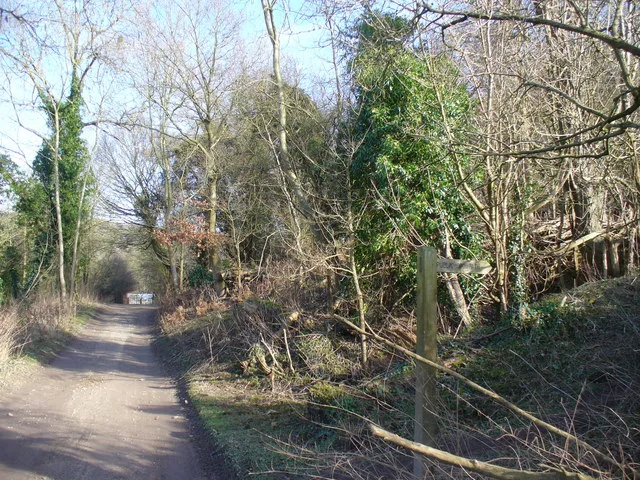
The Tube — a mtb trail in england london.

N Chadwick — CC BY-SA 2.0 via Wikimedia Commons licence

Plan your visit
- Typical visit
- 1 h–2 h
- Nearest railway station
- Gomshall · 1.0 km
About
The Tube is a mtb trail located in england london, mapped by OpenStreetMap contributors. Detailed amenities and visitor information may vary; check the OSM page for the latest tagged metadata.
Photo gallery
Protected designations
- Area of Outstanding Natural Beauty: Surrey Hills
Designations sourced from Natural England open data under OGL v3.
Place summary
The Tube is a mountain biking trail located in London. It offers a range of terrain suitable for various skill levels, making it accessible for both beginners and experienced riders. The trail features a mix of natural and constructed features, providing a challenging yet enjoyable ride. Expect a well-maintained path that showcases the urban landscape, integrating cycling with the city's vibrant atmosphere.
AI-generated from the structured facts on this page (operator, designation, listing, era). Not a substitute for visiting.
- Coordinates
- 51.2281, -0.4440
- County
- Surrey
- District
- Guildford
- Parish
- Shere
- Postcode
- GU5 9QB
- Parliamentary constituency
- Godalming and Ash
- Nearest railway station
- Gomshall — 1 km
Sources
- osm: r18081199 (ODbL)
Other places nearby

The Tube
Mountain bike trails · 0.3 km

Little Kings Wood viewpoint
Viewpoints · 0.6 km

Gomshall
Villages · 1.0 km

Netley House
Manor houses · 1.0 km
Piney Copse
Archaeological sites · 1.2 km

Tower Hill Manor
Manor houses · 1.3 km

BW 11
Mountain bike trails · 1.3 km
BW 11
Mountain bike trails · 1.4 km

BW 153
Mountain bike trails · 1.5 km

BW 143
Mountain bike trails · 1.5 km

Abinger Hammer Clock
Natural landmarks · 1.5 km

North Downs Way - Hollister Farm
Mountain bike trails · 1.6 km
Nearby
📷 5📷 5Viewpoints · South East England
Little Kings Wood viewpoint
Little Kings Wood viewpoint is a viewpoint in the United Kingdom.
📷 5📷 5Manor houses · South East England
Netley House
Netley House — a manor in South East England, United Kingdom.
📷 5📷 5Manor houses · South East England
Tower Hill Manor
Tower Hill Manor — Grade II listed building-listed manor in england-london, United Kingdom.
Where to eat & stay near The Tube
Places to stay
 📷 7
 📷 5
 📷 5
Hostels · South East England
Hurtwood Hideout
Hurtwood Hideout — a hostel in england south east.
 📷 5
Caravan parks · South East England
Edgeley Holiday Park
Edgeley Holiday Park — a caravan park in england south east.
 📷 5
Campsites · South East England
Bentley Copse Activity Centre
Bentley Copse Activity Centre — a campsite in england south east.
 📷 5
Campsites · South East England
Dorking Scouts Camp Site
Dorking Scouts Camp Site — a campsite in england london.
Places to eat & drink
 📷 7
Historic pubs · South East England
Duke Of Wellington Public House
Duke Of Wellington Public House in England South East, United Kingdom.
 📷 7
Historic pubs · South East England
The Bulls Head Public House
The Bulls Head Public House in England South East, United Kingdom.
 📷 5
Historic pubs · South East England
The Windsor Castle Public House
The Windsor Castle Public House in England South East, United Kingdom.
 📷 7
 📷 7
 📷 7
Historic pubs · London
The Ship Inn And Ye Olde Sweet Shoppe
The Ship Inn And Ye Olde Sweet Shoppe in England London, United Kingdom.
More places in this region
 📷 5
 📷 5
 📷 5
 📷 5
Frequently asked questions
- Where is The Tube?
- The Tube is in Surrey, South-East England, United Kingdom (postcode GU5 9QB), in the parish of Shere.
- What is The Tube?
- The Tube — a mtb trail in england london.
- How do I get to The Tube?
- The nearest railway station is Gomshall, about 1.0 km away. The nearest town is Effingham. Drivers can use postcode GU5 9QB.
- Is The Tube a protected site?
- Yes — The Tube is part of the Surrey Hills National Landscape (AONB).
- How do I get to The Tube?
- The nearest railway station is Gomshall, about 1.0 km away. Drivers can navigate to postcode GU5 9QB.