Parks · North East England
The Carrs
In or near Coxhoe.
The Carrs in England North East, United Kingdom.

Trevor Littlewood — CC BY-SA 2.0 via Wikimedia Commons licence
Plan your visit
- Typical visit
- 1 h–2 h
- Nearest railway station
- Newton Aycliffe · 9.1 km
- Free entry
- Family-friendly
- Dog-friendly
Getting there & planning your visit
The Carrs is located in County Durham, with the nearest railway station being Newton Aycliffe, approximately 9.1 km away. The postcode for The Carrs is DL17 8SX. Entry to the park is free, and accessibility details are not provided.
About
The Carrs is a place of interest in England North East, United Kingdom — drawn from open-data sources for visitor reference. See the linked Wikipedia article for the full description.
Photo gallery
Official information
The Carrs is a Site of Special Scientific Interest (SSSI) located in County Durham, recognized for its biological interest. Visitors can explore the natural features and habitats that contribute to the site's ecological significance.
Protected designations
- Site of Special Scientific Interest: The Carrs SSSI
Designations sourced from Natural England open data under OGL v3.
From the Wikipedia article
The Carrs is a Site of Special Scientific Interest in County Durham, England. It is situated on the eastern outskirts of Ferryhill, between the town and the East Coast Main Line railway. The Carrs is an area of wetland that has formed in the low-lying parts of a glacial meltwater channel. A large part of the site is open water, which is fringed by fen vegetation. Woodland and calcareous grassland cover the steep slopes on the western side of the site, where there is also a disused quarry. The site's importance lies mainly in its areas of open water and fen vegetation, which are scarce habitats in lowland County Durham. There is also a small area of equally scarce magnesian limestone grassland, in which blue moor-grass, Sesleria albicans, and glaucous sedge, Carex flacca, are dominant. The site adjoins the Ferryhill Carrs Local Nature Reserve, which extends to the north, alongside the railway line.
Excerpt from Wikipedia under CC BY-SA 4.0. See the source article linked in Sources below.
- Coordinates
- 54.6889, -1.5339
- District
- County Durham
- Parish
- Ferryhill
- Postcode
- DL17 8SX
- Parliamentary constituency
- Newton Aycliffe and Spennymoor
- Established
- 1988
- Nearest railway station
- Newton Aycliffe — 9.1 km
- Official site
- designatedsites.naturalengland.org.uk
Sources
Other places nearby

Thrislington
Vineyards · 0.9 km

Ferryhill railway station
Heritage railway stations · 0.9 km

War Memorial Affixed to Memorial Cottage
Memorials & monuments · 1.0 km

Chilton
Other places · 1.0 km
Ferryhill
Cathedrals · 1.0 km

Ferryhill Station
Heritage railway stations · 1.1 km

Mainsforth Colliery 1972-1968
Memorials & monuments · 1.2 km

Thrislington Plantation National Nature Reserve
Forests & woodlands · 1.3 km
Mainsforth Colliery
Mines & mining heritage · 1.3 km
East Howle and Crossings War Memorial
Memorials & monuments · 1.3 km

Ferryhill War Memorial
Memorials & monuments · 1.4 km

Ferryhill Town Hall
Chapels · 1.4 km
Nearby
📷 5Vineyards · North East England
Thrislington
Thrislington — a UK vineyard in scotland lowlands, producing English or Welsh wine from cool-climate grape varieties.
📷 5Heritage railway stations · North East England
Ferryhill railway station
Ferryhill railway station in England North East, United Kingdom.
📷 3Memorials & monuments · North East England
War Memorial Affixed to Memorial Cottage
War Memorial Affixed to Memorial Cottage — Grade II listed building-listed memorial in scotland-lowlands, United Kingdom.
📷 5Other places · North East England
Chilton
Chilton in England North East, United Kingdom.
📷 5Cathedrals · North East England
Ferryhill
Ferryhill in England North East, United Kingdom.
📷 3Heritage railway stations · North East England
Ferryhill Station
Ferryhill Station in England North East, United Kingdom.
Where to eat & stay near The Carrs
Places to stay
 📷 5
📷 5Hotels · North East England
The Old Mill Hotel
The Old Mill Hotel — a hotel in scotland lowlands.
 📷 5
📷 5Caravan parks · North East England
Grove Farm caravan site
Grove Farm caravan site — a caravan park in scotland lowlands.
 📷 5
📷 5Hotels · North East England
The Hardwick Arms
The Hardwick Arms — a hotel in scotland lowlands.
 📷 5
📷 5Campsites · North East England
Todd's House Farm Campsite
Todd's House Farm Campsite — a campsite in scotland lowlands.
 📷 5
📷 5Caravan parks · North East England
Woodside Ridge Caravan Park
Woodside Ridge Caravan Park — a caravan park in scotland lowlands.
 📷 2
📷 2Caravan parks · North East England
Donnewell Farm Campsite
Donnewell Farm Campsite — a caravan park in scotland lowlands.
Places to eat & drink
 📷 3
📷 3 📷 5
📷 5Historic pubs · North East England
Dun Cow Public House And 2 Mounting Blocks At Front At Rear
Dun Cow Public House And 2 Mounting Blocks At Front At Rear in England North East, United Kingdom.
 📷 5
📷 5Historic pubs · North East England
No.41 (The Green Tree Public House) And No.43
No.41 (The Green Tree Public House) And No.43 in England North East, United Kingdom.
 📷 5
📷 5Restaurants · North East England
Amaani Restaurant
Amaani Restaurant — a restaurant in scotland lowlands.
 📷 5
📷 5Cafés · North East England
Breaking Bread Kitchen and Bakehouse
Breaking Bread Kitchen and Bakehouse — a café in scotland lowlands.
📷 5Historic pubs · North East England
5, Market Place
5, Market Place in Scotland Lowlands, United Kingdom.
More parks in this region
 📷 3
📷 3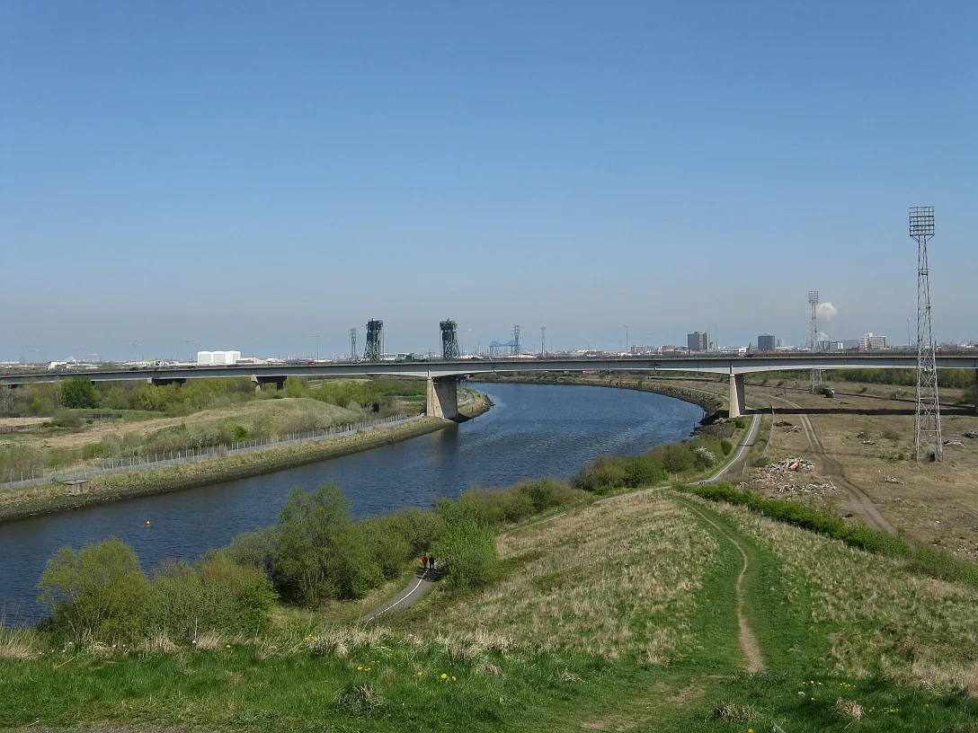 📷 4
📷 4Parks · North East England
Maze Park Nature Reserve
Maze Park Nature Reserve — park in Middlesbrough, United Kingdom.
 📷 3
📷 3Parks · North East England
Portrack Incinerator
Portrack Incinerator — former waste and power plant in England.
 📷 3
📷 3Parks · North East England
Preston Park, Stockton-on-Tees
Preston Park, Stockton-on-Tees — public park in north eastern England.
Frequently asked questions
- Where is The Carrs?
- The Carrs is in North-East England, United Kingdom (postcode DL17 8SX), in the parish of Ferryhill.
- What is The Carrs?
- The Carrs in England North East, United Kingdom.
- How do I get to The Carrs?
- The nearest railway station is Newton Aycliffe, about 9.1 km away. Drivers can use postcode DL17 8SX.
- When was The Carrs built?
- Built or established in 1988.
- Is The Carrs a protected site?
- Yes — The Carrs is part of the The Carrs SSSI Site of Special Scientific Interest.
- How do I get to The Carrs?
- Drivers can navigate to postcode DL17 8SX. It sits within the Newton Aycliffe and Spennymoor parliamentary constituency.