Mountains & hills · North West England
The Calf
In or near Grayrigg.
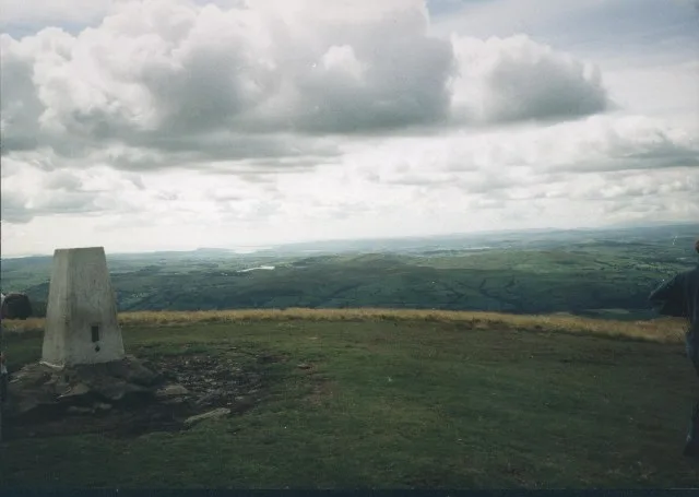
The Calf — Named summit at 676.7 m.

Wikimedia Commons contributors — see linked file page for photographer and licence licence
Plan your visit
- Typical visit
- 3 h–8 h
- Best time of year
- Late spring – early autumn (May–Oct)
- Free entry
- Dog-friendly
About
The Calf is a named summit in the United Kingdom. Wikidata describes it as: "Named summit at 676.7 m.". Coordinates: 54.3679°, -2.5135°.
Photo gallery
360° viewimagery from 2022
Imagery © Mapillary contributors, CC BY-SA 4.0
Protected designations
- Site of Special Scientific Interest: River Eden and Tributaries SSSI
Designations sourced from Natural England open data under OGL v3.
From the Wikipedia article
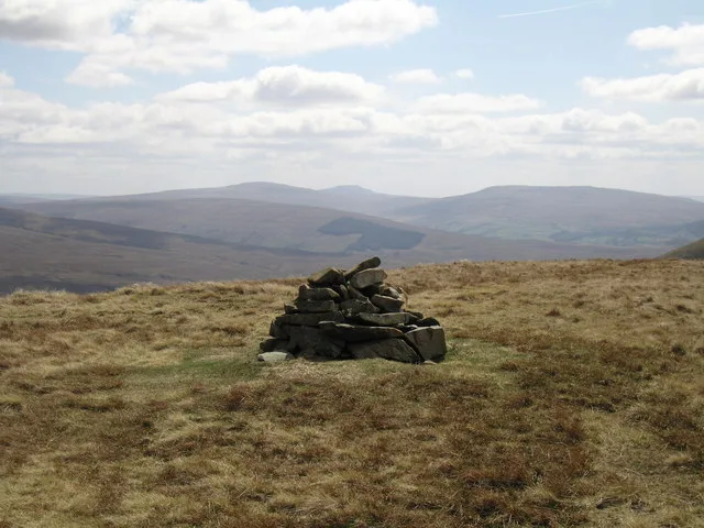
The Calf, at an elevation of 676 metres (2,218 ft), is the highest point in the Howgill Fells, an area of high ground in north-west England. It is in the north-west of the Yorkshire Dales in Westmorland and Furness in the county of Cumbria (historically it was on the West Riding of Yorkshire/Westmorland boundary). It can be ascended from the town of Sedbergh to the south, by way of Cautley Spout from the east, or up the long valley of Langdale from the north. The Sedbergh ascent is the most popular, and has the distinction of being on good paths all the way. The summit commands an extensive panorama, although foreground detail is obscured by the extreme flatness of the plateau. A twenty-mile skyline of the Lakeland peaks can be seen, as well as the Yorkshire Three Peaks and many of the nearer Howgill Fells. Alfred Wainwright, in his Walks on the Howgill Fells, describes a route from Sedbergh to Calders and The Calf as "the classic high-level walk on the Howgill Fells". He includes a drawing of the trig point on the summit of The Calf, discusses a "reclining" standing stone 400 yards to the north-east which appears on large-scale Ordnance Survey maps, and spends a column of text discussing "the altitude of Calders", which he estimates as 2215 ft. He gives diagrams of the views covering the full 360 degrees, and sketches of the Lakeland skyline and the view of the Yorkshire Three Peaks to the south-east. He also describes ascents of the Calf from Castley ("this impressive expedition", "a beautiful walk"), Beck Houses farm on the west of the Howgills (" this high-level traverse of the plateau splendidly reveals the topographical details of the Howgills") and Bowderdale ("the longest direct ascent of The Calf"). Calders, at 674 metres (2,211 ft), is about 1 km SSE of the summit of The Calf. It is classified as a Hewitt.
Excerpt from Wikipedia under CC BY-SA 4.0. See the source article linked in Sources below.
- Coordinates
- 54.3679, -2.5135
Sources
- osm: n9439548715 (ODbL)
- wikipedia: The Calf (CC BY-SA 4.0)
- commons: The Calf summit.jpg (CC BY-SA 4.0)
Featured in this guide
Other places nearby
The Calf
Natural landmarks · 0.1 km

Bram Rigg Top
Mountains & hills · 0.6 km

Red Gill Washfold
Public art & sculpture · 1.0 km

Calders
Mountains & hills · 1.1 km

Great Dummacks
Mountains & hills · 1.4 km

Cautley Spout
Waterfalls · 1.4 km

Cobles
Mountains & hills · 1.8 km

Fell Head
Mountains & hills · 2.1 km
Fell Head
Mountains & hills · 2.1 km

Brown Moor
Mountains & hills · 2.3 km
Yarlside
Mountains & hills · 2.3 km

Arant Haw
Mountains & hills · 2.5 km
Nearby
📷 3📷 5Mountains & hills · North West England
Bram Rigg Top
Bram Rigg Top — mountain in england north west. Elevation: 672 m.
📷 3Public art & sculpture · North West England
Red Gill Washfold
Red Gill Washfold — Public artwork (sculpture) by Andy Goldsworthy.
📷 4Mountains & hills · North West England
Calders
Calders — a mountain in england-north-west, United Kingdom.
📷 5Mountains & hills · North West England
Great Dummacks
Great Dummacks — mountain in england north west. Elevation: 663 m.
📷 5Where to eat & stay near The Calf
Places to stay
 📷 5
📷 5Caravan parks · North West England
Cross Hall Caravan Park
Cross Hall Caravan Park — a caravan park in england north west.
📷 5Caravan parks · North West England
Cross Hall Camp Site
Cross Hall Camp Site — a caravan park in england north west.
 📷 5
📷 5Hotels · North West England
The Black Bull
The Black Bull — a hotel in england north west.
 📷 5
📷 5Caravan parks · North West England
Pinfold Caravan Park
Pinfold Caravan Park — a caravan park in england north west.
 📷 5
📷 5Hostels · North West England
Longrigg Centre
Longrigg Centre — a hostel in england north west.
 📷 5
📷 5Campsites · North West England
Farm & Fell
Farm & Fell — a campsite in england north west.
Places to eat & drink
 📷 5
📷 5Cafés · North West England
The Cross Keys Temperance Inn
The Cross Keys Temperance Inn — a café in england north west.
 📷 5
📷 5Cafés · North West England
Gun Dog Coffee Shop
Gun Dog Coffee Shop — a café in england north west.
 📷 7
📷 7Cafés · North West England
The White Hare Cafe
The White Hare Cafe — a café in england north west.
 📷 5
📷 5Historic pubs · North East England
1, Scattergate
1, Scattergate in England North East, United Kingdom.
 📷 5
📷 5 📷 5
📷 5Historic pubs · North West England
Punch Bowl Hotel
Punch Bowl Hotel in England North West, United Kingdom.
More mountains in this region
 📷 5
📷 5Mountains & hills · North West England
Appleton Park
Appleton Park — a hill or mountain in england west midlands.
 📷 5
📷 5Mountains & hills · North West England
High Warren
High Warren — mountain in england west midlands. Elevation: 105 m.
 📷 5
📷 5Mountains & hills · North West England
Alderley Edge
Alderley Edge — mountain in england west midlands. Elevation: 194 m.
 📷 3
📷 3Frequently asked questions
- Where is The Calf?
- The Calf is in North-West England, United Kingdom.
- What is The Calf?
- The Calf — Named summit at 676.7 m.
- How do I get to The Calf?
- Its coordinates are 54.3679°, -2.5135°.
- Is The Calf a protected site?
- Yes — The Calf is part of the River Eden and Tributaries SSSI Site of Special Scientific Interest.
- Is The Calf free to visit?
- Yes, The Calf is free to enter.