
Mountains & hills · Central Scotland
Stob na Boine Druim-fhinn
In or near Cairndow.
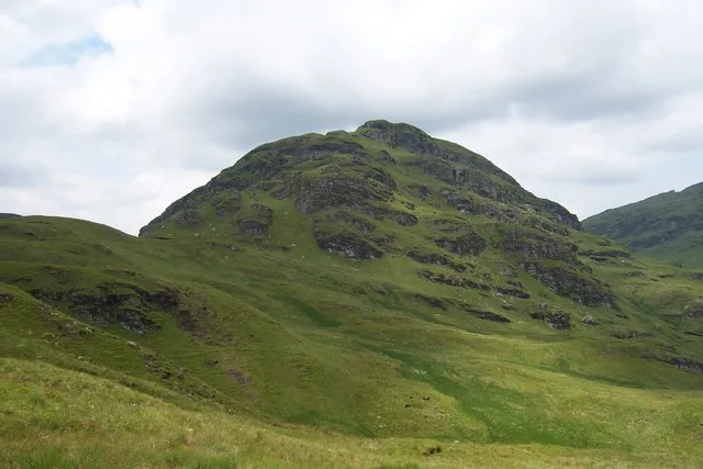
Stob na Boine Druim-fhinn — Named summit at 658 m.

Wikimedia Commons contributors — see linked file page for photographer and licence licence

Plan your visit
- Typical visit
- 3 h–8 h
- Best time of year
- Late spring – early autumn (May–Oct)
- Free entry
- Dog-friendly
About
Stob na Boine Druim-fhinn is a named summit in the United Kingdom. Wikidata describes it as: "Named summit at 658 m.". Coordinates: 56.1804°, -4.9516°.
Photo gallery
Official information
Stob na Boine Druim-fhinn is a geographical feature located in Argyllshire, Scotland. It is part of the Ordnance Survey records that document place names and their significance in the region.
From the Wikipedia article
Stob na Boine Druim-fhinn is a mountain on the Cowal peninsula in Argyll, Scotland, northwest of Lochgoilhead. On 17 January 1949, a United States Army Air Forces Boeing B-29 Superfortress (44-62279) of the 31st Test and Evaluation Squadron was on a flight from RAF Scampton, England, to Reykjavík, Iceland. At 9:50am, the B-29 crashed into the side of Stob na Boine Druim-fhinn, killing all twenty passengers and crew. The cause of the crash was not determined, but the adverse weather and heavy icing were deemed to be contributory factors.
Excerpt from Wikipedia under CC BY-SA 4.0. See the source article linked in Sources below.
- Coordinates
- 56.1804, -4.9516
- Address
- Argyll and Bute, Scotland
- Official site
- scotlandsplaces.gov.uk
Sources
- osm: n1132335902 (ODbL)
- wikipedia: Stob na Boine Druim-fhinn (CC BY-SA 4.0)
- commons: East face of Stob na Boine Druim-fhinn - geograph.org.uk - 464664.jpg (CC BY-SA 4.0)
Other places nearby
Stob na Boine Druim-fhinn
Natural landmarks · 0.1 km

Mullach Coire a' Chuir
Natural landmarks · 0.9 km

Beinn Tharsuinn
Mountains & hills · 1.0 km
Beinn Tharsuinn
Mountains & hills · 1.0 km

Monadh Beag
Mountains & hills · 2.0 km
Beinn Lochain
Mountains & hills · 2.0 km
Beinn Lochain
Natural landmarks · 2.1 km

Stob Liath
Mountains & hills · 2.7 km
Stob Liath
Mountains & hills · 2.7 km

Bridge over Eas a' Chruisgein, Drimsynie
Historic bridges · 2.7 km

Lochgoilhead Holiday Park
Caravan parks · 2.7 km

Cruach na Cioba
Mountains & hills · 2.8 km
Nearby
📷 3Natural landmarks · Central Scotland
Stob na Boine Druim-fhinn
Stob na Boine Druim-fhinn — mountain in Argyll and Bute, Scotland, UK.
📷 3Natural landmarks · Central Scotland
Mullach Coire a' Chuir
Mullach Coire a' Chuir — mountain in Argyll and Bute, Scotland, UK.
📷 5Mountains & hills · Central Scotland
Beinn Tharsuinn
Beinn Tharsuinn — a hill or mountain in scotland highlands.
📷 5Mountains & hills · Central Scotland
Beinn Tharsuinn
Beinn Tharsuinn — mountain in scotland highlands. Elevation: 619 m.
📷 5Mountains & hills · Central Scotland
Monadh Beag
Monadh Beag — a hill or mountain in scotland highlands.
📷 3Where to eat & stay near Stob na Boine Druim-fhinn
Places to stay
📷 5Caravan parks · Central Scotland
Lochgoilhead Holiday Park
Lochgoilhead Holiday Park — a caravan park in scotland highlands.
 📷 5
📷 5Campsites · Central Scotland
Lochgoilhead Scout Camp
Lochgoilhead Scout Camp — a campsite in scotland highlands.
 📷 5
📷 5Caravan parks · Central Scotland
St Catherine's Caravan Park
St Catherine's Caravan Park — a caravan park in scotland highlands.
 📷 5
📷 5Caravan parks · Central Scotland
Honeymoon Bridge
Honeymoon Bridge — a caravan park in scotland highlands.
 📷 5
📷 5Hostels · Central Scotland
Inveraray Hostel
Inveraray Hostel — a hostel in scotland highlands.
 📷 3
📷 3Campsites · Central Scotland
Coilessan camping permit area March-September
Coilessan camping permit area March-September — a campsite in scotland highlands.
Places to eat & drink
 📷 3
📷 3Historic pubs · Central Scotland
Ardbrecknish House
Ardbrecknish House — Historic pub — listed building or notable heritage status.
 📷 5
📷 5Historic pubs · Central Scotland
The Drovers Inn
The Drovers Inn — Historic pub — listed building or notable heritage status.
 📷 7
📷 7Historic pubs · Central Scotland
Ardencaple Hotel Including Former Stables, Rhu Road Lower, Rhu
Ardencaple Hotel Including Former Stables, Rhu Road Lower, Rhu in Scotland Central, United Kingdom.
More mountains in this region
 📷 3
📷 3 📷 3
📷 3 📷 3
📷 3Mountains & hills · Central Scotland
An Caisteal
An Caisteal — Named summit at 995 m.
 📷 5
📷 5Frequently asked questions
- Where is Stob na Boine Druim-fhinn?
- Stob na Boine Druim-fhinn is in the Scottish Highlands, United Kingdom.
- What is Stob na Boine Druim-fhinn?
- Stob na Boine Druim-fhinn — Named summit at 658 m.
- How do I get to Stob na Boine Druim-fhinn?
- Its coordinates are 56.1804°, -4.9516°.
- Is Stob na Boine Druim-fhinn free to visit?
- Yes, Stob na Boine Druim-fhinn is free to enter.