Mountains & hills · Scottish Highlands
Stob an Duine Ruaidh
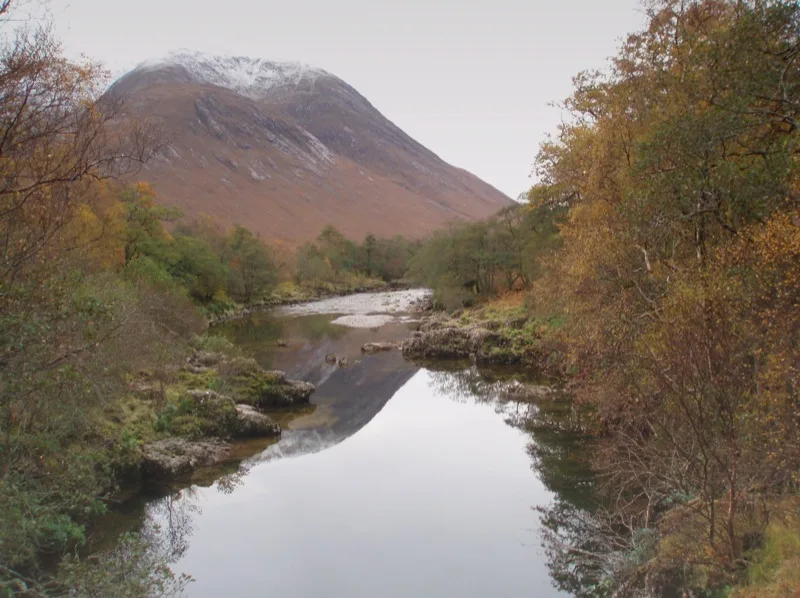
Stob an Duine Ruaidh — mountain in scotland highlands. Elevation: 918 m.

Alan Reid — CC BY-SA 2.0 via Wikimedia Commons licence
Plan your visit
- Typical visit
- 3 h–8 h
- Best time of year
- Late spring – early autumn (May–Oct)
About
Stob an Duine Ruaidh is a mountain located in scotland highlands. Elevation: 918 m. A named British peak recorded in OpenStreetMap. Peaks are typically named on Ordnance Survey 1:50k mapping.
Photo gallery
Place summary
Stob an Duine Ruaidh is a mountain located in the Scottish Highlands. It is part of the Ardgour range and offers notable views of the surrounding landscapes. The area is popular for hiking and outdoor activities, attracting those interested in exploring the rugged terrain. Visitors can expect a challenging ascent and a rewarding panorama from the summit.
AI-generated from the structured facts on this page (operator, designation, listing, era). Not a substitute for visiting.
- Coordinates
- 56.5235, -5.0504
Sources
- osm: n5443375345 (ODbL)
Other places nearby
Loading nearby places…
Nearby
 📷 3
📷 3Mountains & hills · Scottish Highlands
Stob an Duine Ruaidh
Stob an Duine Ruaidh — a mountain in scotland-highlands, United Kingdom.
📷 3Mountains & hills · Scottish Highlands
Meall Cruidh
Meall Cruidh — a mountain in scotland-highlands, United Kingdom.
📷 5Mountains & hills · Scottish Highlands
Meall Cruidh
Meall Cruidh — mountain in scotland highlands. Elevation: 930 m.
 📷 3
📷 3Mountains & hills · Scottish Highlands
Stob Coire Dheirg (1984-1990 position)
Stob Coire Dheirg (1984-1990 position) — a mountain in scotland-highlands, United Kingdom.
 📷 5
📷 5Mountains & hills · Scottish Highlands
Ben Starav
Ben Starav — Named summit at 1078 m.
 📷 5
📷 5Natural landmarks · Scottish Highlands
Ben Starav
Ben Starav — 1078m high mountain in Highland, Scotland, UK.
Where to eat & stay near Stob an Duine Ruaidh
Places to stay
 📷 5
📷 5Hotels · Scottish Highlands
Loch Awe Hotel
Loch Awe Hotel — a hotel in scotland highlands.
 📷 5
📷 5Caravan parks · Scottish Highlands
Loch Awe Holiday Park
Loch Awe Holiday Park — a caravan park in scotland highlands.
 📷 5
📷 5Caravan parks · Scottish Highlands
Airds Bay CL
Airds Bay CL — a caravan park in scotland highlands.
 📷 5
📷 5Caravan parks · Scottish Highlands
Oban Camping & Caravanning Club Site
Oban Camping & Caravanning Club Site — a caravan park in scotland highlands.
 📷 5
📷 5Caravan parks · Scottish Highlands
Creagan Station Tourers Camper Site
Creagan Station Tourers Camper Site — a caravan park in scotland highlands.
 📷 5
📷 5Campsites · Scottish Highlands
Red Squirrel Campsite
Red Squirrel Campsite — a campsite in scotland highlands.


More mountains in this region
 📷 3
📷 3Mountains & hills · Scottish Highlands
A' Bhuidheanach Bheag
A' Bhuidheanach Bheag — Named summit at 936 m.
 📷 3
📷 3Mountains & hills · Scottish Highlands
A' Chailleach
A' Chailleach — Named summit at 997 m.
 📷 3
📷 3Mountains & hills · Scottish Highlands
A' Chailleach
A' Chailleach — Named summit at 930 m.
 📷 3
📷 3Mountains & hills · Scottish Highlands
A' Chaoirnich
A' Chaoirnich — Named summit at 875 m.
Frequently asked questions
- Where is Stob an Duine Ruaidh?
- Stob an Duine Ruaidh is in the Scottish Highlands, United Kingdom.
- What is Stob an Duine Ruaidh?
- Stob an Duine Ruaidh — mountain in scotland highlands. Elevation: 918 m.
- How do I get to Stob an Duine Ruaidh?
- Its coordinates are 56.5235°, -5.0504°.