
Reservoirs & lochs · South West England
Stithians Reservoir
In or near Gwennap.
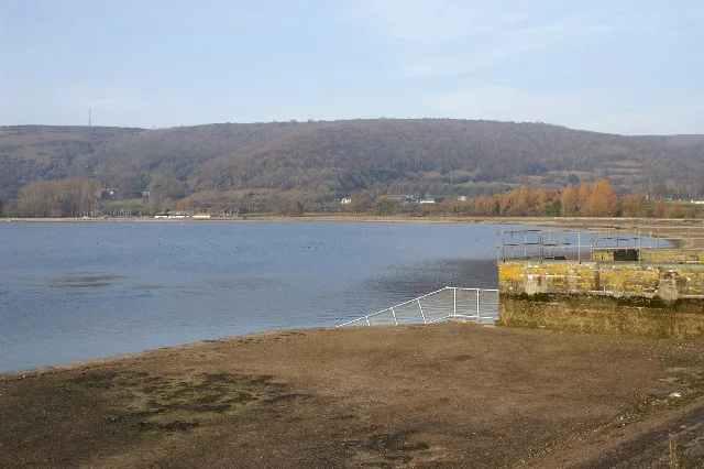
Stithians Reservoir — reservoir in Cornwall, England.

Wikimedia Commons contributors — see linked file page for photographer and licence licence

Plan your visit
- Typical visit
- 1 h–2.5 h
- Nearest railway station
- Redruth · 5.9 km
- Free entry
- Dog-friendly
About
Stithians Reservoir is a reservoir in the United Kingdom. Wikidata describes it as: "reservoir in Cornwall, England". Coordinates: 50.1817°, -5.2044°.
Photo gallery
Protected designations
- Site of Special Scientific Interest: West Cornwall Bryophytes SSSI
- Site of Special Scientific Interest: Lower Fal & Helford Intertidal SSSI
- Area of Outstanding Natural Beauty: Cornwall
Designations sourced from Natural England open data under OGL v3.
From the Wikipedia article
Stithians Reservoir (Cornish: Kreun Stedhyan) is a reservoir situated just under a mile to the west of the village of Stithians, Cornwall, England, UK.
Excerpt from Wikipedia under CC BY-SA 4.0. See the source article linked in Sources below.
Background
History
Work on the dam began on 19 July 1962, however work stopped shortly after due to excavations which revealed the site was over a large area of soft kaolinised granite, which would require expensive foundations. A new design was drawn up for the dam, which was the current arched design. The dam was opened on 13 October 1967 by Sir John Carew Pole, whilst the Bishop of Truro, Dr Maurice Key blessed the reservoir. By the opening in 1967 the valley behind the dam was completely flooded, 274 acres of farmland and three country houses became submerged. Two causeways were built to carry sections of roads that were flooded, one at the southern end and the other in the north western corner near the…
Sourced from Wikipedia under CC BY-SA 4.0.
- Coordinates
- 50.1817, -5.2044
- District
- Cornwall
- Parish
- Stithians
- Postcode
- TR3 7AR
- Parliamentary constituency
- Camborne and Redruth
- Nearest railway station
- Redruth — 5.9 km
Sources
- wikidata: Q7372607 (CC0)
- wikipedia: Stithians Reservoir (CC BY-SA 4.0)
- commons: Stithians Dam - geograph.org.uk - 194873.jpg (CC BY-SA 4.0)
Other places nearby

Birdwatching Hide
Viewpoints · 1.1 km

Bridge At Sw704354
Historic bridges · 1.2 km
Penmarth
Historic churches · 1.2 km

Wayside cross 100m south east of Tretheague House
Historic houses · 1.6 km

Carnmenellis
Mountains & hills · 1.8 km
Carnmenellis
Mountains & hills · 1.8 km

Pottery Campsite
Campsites · 1.8 km

Little White Alice
Hostels · 1.9 km

Church of Saint Stedian
Historic churches · 2.0 km
Wayside cross in St Stithians churchyard
Historic churches · 2.0 km
Stithians War Memorial
Memorials & monuments · 2.0 km

Stithians
Historic churches · 2.2 km
Nearby
📷 5Viewpoints · South West England
Birdwatching Hide
Birdwatching Hide is a viewpoint in the United Kingdom.
📷 3Historic bridges · South West England
Bridge At Sw704354
Bridge At Sw704354 — Grade II listed building-listed bridge in england-south-west, United Kingdom.
📷 5Historic churches · South West England
Penmarth
Penmarth (Cornish: Pollmargh) is a hamlet in Cornwall, England, United Kingdom, about 4 miles (6.4 km) west of Penryn and about 4 miles (6.4 km) south of Redruth. The hamlet is often referred to as Ca
📷 3Historic houses · South West England
Wayside cross 100m south east of Tretheague House
Wayside cross 100m south east of Tretheague House — a Grade II-listed historic house in england-south-west, United Kingdom.
📷 5Mountains & hills · South West England
Carnmenellis
Carnmenellis — a hill or mountain in england south west.
📷 5Mountains & hills · South West England
Carnmenellis
Carnmenellis — mountain in england south west. Elevation: 252 m.
Where to eat & stay near Stithians Reservoir
Places to stay
📷 5📷 4Hostels · South West England
Little White Alice
Little White Alice — a hostel in england south west.
 📷 5
📷 5Caravan parks · South West England
Retanna Holiday Park
Retanna Holiday Park — a caravan park in england south west.
 📷 5
📷 5 📷 5
📷 5 📷 5
📷 5Places to eat & drink
 📷 3
📷 3Historic pubs · South West England
Seven Stars
Seven Stars — Historic pub — listed building or notable heritage status.
 📷 5
📷 5Historic pubs · South West England
Kings Arms
Kings Arms — Historic pub — listed building or notable heritage status.
 📷 5
📷 5Historic pubs · South West England
The Famous Barrel Public House
The Famous Barrel Public House in England South West, United Kingdom.
 📷 7
📷 7Historic pubs · South West England
The Pendarves Arms
The Pendarves Arms in England South West, United Kingdom.
 📷 6
📷 6Historic pubs · South West England
Seven Stars, Falmouth
Seven Stars, Falmouth in England South West, United Kingdom.
 📷 5
📷 5Historic pubs · South West England
The Kimberley Public House
The Kimberley Public House in England South West, United Kingdom.
More places in this region
 Flagship📷 10
Reservoirs & lochs · South West England
Cheddar Reservoir
Cheddar Reservoir — reservoir in Somerset, England.
 📷 5
📷 5Reservoirs & lochs · South West England
Ashford Reservoir
Ashford Reservoir — reservoir in Somerset, England, UK.
 📷 5
📷 5Reservoirs & lochs · South West England
Burrator Reservoir
Burrator Reservoir — reservoir in Devon, England.
 📷 5
📷 5Reservoirs & lochs · South West England
Chard Reservoir
Chard Reservoir — reservoir in Somerset, England, UK.
Frequently asked questions
- Where is Stithians Reservoir?
- Stithians Reservoir is in South-West England, United Kingdom (postcode TR3 7AR), in the parish of Stithians.
- What is Stithians Reservoir?
- Stithians Reservoir — reservoir in Cornwall, England.
- How do I get to Stithians Reservoir?
- The nearest railway station is Redruth, about 5.9 km away. The nearest town is Gwennap. Drivers can use postcode TR3 7AR.
- Is Stithians Reservoir a protected site?
- Yes — Stithians Reservoir is part of the West Cornwall Bryophytes SSSI Site of Special Scientific Interest and the Lower Fal & Helford Intertidal SSSI Site of Special Scientific Interest.
- Is Stithians Reservoir free to visit?
- Yes, Stithians Reservoir is free to enter.
- How do I get to Stithians Reservoir?
- The nearest railway station is Redruth, about 5.9 km away. Drivers can navigate to postcode TR3 7AR.