
Archaeological sites · Yorkshire & the Humber
Stanwick Iron Age Fortifications
In or near Eppleby.
Stanwick Iron Age Fortifications — a archaeological in england-yorkshire, United Kingdom.

Gordon Hatton — CC BY-SA 2.0 via Wikimedia Commons licence

Plan your visit
- Typical visit
- 45 min–1.5 h
- Free entry
- Dog-friendly
About
Stanwick Iron Age Fortifications is a archaeological located in england-yorkshire, United Kingdom. Sourced from OpenStreetMap (ODbL licence); see local listings for visitor information, opening hours and admission details.
Photo gallery
Official information
Stanwick Iron Age Fortifications are the remains of 1st century AD defensive structures built by the Brigantes tribe. The site features a complex of earthworks that indicate multiple phases of development and includes significant archaeological finds such as pottery and an Iron Age sword.
Place summary
Stanwick Iron Age Fortifications are located in Yorkshire. This archaeological site features extensive earthworks dating back to the Iron Age, representing one of the largest known fortification systems from that period in Britain.
AI-generated from the structured facts on this page (operator, designation, listing, era). Not a substitute for visiting.
- Coordinates
- 54.4988, -1.7191
- District
- North Yorkshire
- Parish
- Stanwick St. John
- Postcode
- DL11 7RT
- Parliamentary constituency
- Richmond and Northallerton
- Official site
- www.pastscape.org.uk
Sources
- osm: node/2754355274 (ODbL)
Other places nearby

Stanwick Iron Age Hill Fort
Hill forts · 0.2 km
Stanwick Park
Historic houses · 0.2 km
Stanwick St John
Historic bridges · 0.4 km

Kirk Bridge
Historic bridges · 0.4 km
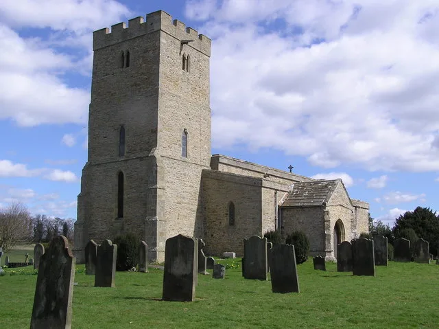
St John the Baptist's Church, Stanwick
Historic churches · 0.5 km

Stanwick Camp
Archaeological sites · 0.6 km

Forcett
Other places · 0.9 km

Forcett
Villages · 1.1 km

Bridge Over Aldbrough Beck
Historic bridges · 1.3 km

Forcett Hall
Historic houses · 1.4 km

Eppleby
Towns & cities · 1.7 km

Aldbrough St John Packhorse Bridge
Historic bridges · 1.9 km
Nearby
📷 3Hill forts · Yorkshire & the Humber
Stanwick Iron Age Hill Fort
Stanwick Iron Age Hill Fort — a hill fort in england-yorkshire, United Kingdom.
📷 4Historic houses · North East England
Stanwick Park
Stanwick Park in England North East, United Kingdom.
📷 5Historic bridges · North East England
Stanwick St John
Stanwick St John in England North East, United Kingdom.
📷 3Historic bridges · North East England
Kirk Bridge
Kirk Bridge — Grade II listed building-listed bridge in england-north-east, United Kingdom.
📷 3Historic churches · North East England
St John the Baptist's Church, Stanwick
St John the Baptist's Church, Stanwick — church in Stanwick St John, North Yorkshire, England, UK.
📷 5Archaeological sites · North East England
Stanwick Camp
Stanwick Camp in England North East, United Kingdom.
Where to eat & stay near Stanwick Iron Age Fortifications
Places to stay
 📷 7
📷 7 📷 5
📷 5Caravan parks · North East England
Hillcrest Caravan Park
Hillcrest Caravan Park — a caravan park in england north east.
 📷 5
📷 5Caravan parks · Yorkshire & the Humber
Richmond Hargill House Caravan Club Site
Richmond Hargill House Caravan Club Site — a caravan park in england yorkshire.
 📷 5
📷 5Campsites · North East England
Winston Caravan Park
Winston Caravan Park — a campsite in england north east.
 📷 5
📷 5Caravan parks · Yorkshire & the Humber
Tavern House Caravan Park
Tavern House Caravan Park — a caravan park in england yorkshire.
 📷 5
📷 5Campsites · North East England
Thorpe Farm Centre Campsite
Thorpe Farm Centre Campsite — a campsite in england north east.
Places to eat & drink
 📷 4
📷 4 📷 5
📷 5Historic pubs · North East England
Milbank Arms
Milbank Arms in England North East, United Kingdom.
 📷 5
📷 5Cafés · North East England
The Country Teashop
The Country Teashop — a café in england north east.
 📷 7
📷 7Cafés · North East England
Influence Cafe
Influence Cafe — a café in england north east.
 📷 7
📷 7Historic pubs · North East England
The Comet Public House
The Comet Public House in England North East, United Kingdom.
 📷 4
📷 4Historic pubs · North East England
The Bar
The Bar in England North East, United Kingdom.
More archaeological sites in this region
 📷 3
📷 3Archaeological sites · Yorkshire & the Humber
Mellor Mill dig site
Mellor Mill dig site — a archaeological in england-west-midlands, United Kingdom.
 📷 3
📷 3Archaeological sites · Yorkshire & the Humber
Industrial Chimney
Industrial Chimney — a archaeological in england-west-midlands, United Kingdom.
 📷 3
📷 3Archaeological sites · Yorkshire & the Humber
The Dipping Stone
The Dipping Stone — a archaeological in england-west-midlands, United Kingdom.
 📷 3
📷 3Archaeological sites · Yorkshire & the Humber
Murder Stone
Murder Stone — a archaeological in england-west-midlands, United Kingdom.
Frequently asked questions
- Where is Stanwick Iron Age Fortifications?
- Stanwick Iron Age Fortifications is in Yorkshire, United Kingdom (postcode DL11 7RT), in the parish of Stanwick St. John.
- What is Stanwick Iron Age Fortifications?
- Stanwick Iron Age Fortifications — a archaeological in england-yorkshire, United Kingdom.
- How do I get to Stanwick Iron Age Fortifications?
- Drivers can use postcode DL11 7RT.
- Is Stanwick Iron Age Fortifications free to visit?
- Yes, Stanwick Iron Age Fortifications is free to enter.
- How do I get to Stanwick Iron Age Fortifications?
- Drivers can navigate to postcode DL11 7RT. It sits within the Richmond and Northallerton parliamentary constituency.