Historic houses · North East England
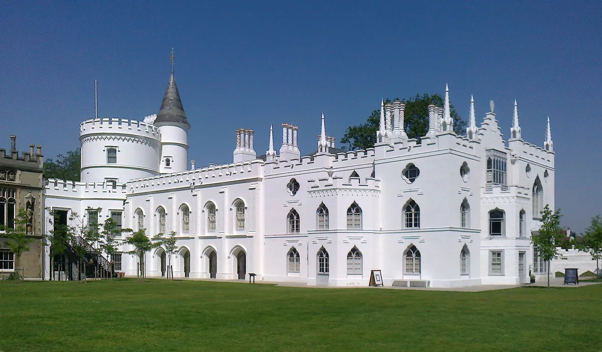
Stanhope Castle
In or near Stanhope.
Stanhope Castle — house in Stanhope, County Durham, England, UK.
_-_geograph.org.uk_-_1640579.jpg?width=1200)
Wikimedia Commons contributors — see linked file page for photographer and licence licence
_-_geograph.org.uk_-_1640579.jpg)
Plan your visit
- Typical visit
- 1 h–2 h
- Nearest railway station
- Stanhope · 0.5 km
- Family-friendly
- Limited wheelchair access
About
Stanhope Castle is a historic house in the Scottish Lowlands. Built or established in 1798, it dates from the Georgian period. Officially recognised as Grade II* listed building. The site is within the North Pennines National Landscape (AONB), and is a designated Site of Special Scientific Interest. It sits within the Bishop Auckland parliamentary constituency. The nearest railway station is Stanhope, about 0.5 km away. Postcode area DL13.
Photo gallery
See it from the streetimagery from 2019
Imagery © Mapillary contributors, CC BY-SA 4.0
Protected designations
- Site of Special Scientific Interest: Muggleswick, Stanhope and Edmundbyers Commons and Blanchland Moor SSSI
- Area of Outstanding Natural Beauty: North Pennines
Designations sourced from Natural England open data under OGL v3.
Place summary
Stanhope Castle is a Georgian historic house located in the Scottish Lowlands, within the parish of Stanhope, postcode DL13. Established in 1798, it is a Grade II* listed building and is situated within the North Pennines Area of Outstanding Natural Beauty (AONB) and the Muggleswick, Stanhope and Edmundbyers Commons and Blanchland Moor Site of Special Scientific Interest (SSSI).
AI-generated from the structured facts on this page (operator, designation, listing, era). Not a substitute for visiting.
- Coordinates
- 54.7474, -2.0075
- District
- County Durham
- Parish
- Stanhope
- Postcode
- DL13 2PZ
- Parliamentary constituency
- Bishop Auckland
- Established
- 1798
- Nearest railway station
- Stanhope — 0.5 km
Sources
- wikidata: Q17536587 (CC0)
- commons: Stanhope Castle (view NW) - geograph.org.uk - 1640579.jpg (CC BY-SA 4.0)
Other places nearby

Stanhope Castle
Literary houses · 0.0 km

Stanhope War Memorial
Memorials & monuments · 0.1 km

Stanhope
Towns & cities · 0.1 km

Regenerare
Public art & sculpture · 0.1 km

Stanhope Caravan Park
Caravan parks · 0.2 km

Stanhope Town Hall
Historic houses · 0.3 km

Unthank Hall
Historic houses · 0.5 km

Stanhope railway station
Heritage railway stations · 0.5 km
Weardale Railway
Heritage railways · 0.5 km

Stanhope
Villages · 0.7 km

Stanhope Hall
Historic houses · 0.7 km

Heather View Country and Leisure Park
Caravan parks · 0.8 km
Nearby
📷 5Literary houses · North East England
Stanhope Castle
Stanhope Castle — a literary house museum in scotland lowlands.
📷 3Memorials & monuments · North East England
Stanhope War Memorial
Stanhope War Memorial — a memorial in scotland-lowlands, United Kingdom.
📷 4📷 3Public art & sculpture · North East England
Regenerare
Regenerare — a public art in scotland-lowlands, United Kingdom.
📷 5Caravan parks · North East England
Stanhope Caravan Park
Stanhope Caravan Park — a caravan park in scotland lowlands.
📷 4Historic houses · North East England
Stanhope Town Hall
Stanhope Town Hall in England North East, United Kingdom.
Where to eat & stay near Stanhope Castle
Places to stay
📷 5Caravan parks · North East England
Stanhope Caravan Park
Stanhope Caravan Park — a caravan park in scotland lowlands.
📷 5Caravan parks · North East England
Heather View Country and Leisure Park
Heather View Country and Leisure Park — a caravan park in scotland lowlands.
 📷 5
📷 5Caravan parks · North East England
Belle Vue Caravan Site
Belle Vue Caravan Site — a caravan park in scotland lowlands.
 📷 5
📷 5Caravan parks · North East England
Betsdale Caravan Park
Betsdale Caravan Park — a caravan park in scotland lowlands.
 📷 5
📷 5Caravan parks · North East England
Frosterley Inn Caravan Park
Frosterley Inn Caravan Park — a caravan park in scotland lowlands.
 📷 5
📷 5Hostels · North East England
Hiole House Bunkhouse
Hiole House Bunkhouse — a hostel in scotland lowlands.
Places to eat & drink
 📷 5
📷 5Historic pubs · North East England
Black Bull Public House
Black Bull Public House in Scotland Lowlands, United Kingdom.
 📷 5
📷 5Historic pubs · North East England
The Lord Crewe Arms Hotel
The Lord Crewe Arms Hotel in Scotland Lowlands, United Kingdom.
 📷 5
📷 5Cafés · North East England
The White Monk Tearoom
The White Monk Tearoom — a café in scotland lowlands.
 📷 3
📷 3 📷 4
📷 4Historic pubs · North East England
Delves Lane
Delves Lane in England North East, United Kingdom.
 📷 5
📷 5Historic pubs · North East England
Queens Head Public House
Queens Head Public House in Scotland Lowlands, United Kingdom.
Other historic houses from this era
 Flagship📷 10
Historic houses · London
Strawberry Hill House
Strawberry Hill House — villa and house museum in Twickenham, London, United Kingdom.
 📷 5
📷 5Historic houses · London
12, Upper Grosvenor Street W1
12, Upper Grosvenor Street W1 — House in Mayfair, London W1.
 📷 5
📷 5Historic houses · London
123 Mortlake High Street
123 Mortlake High Street — house and former town hall in Mortlake, London.
 📷 5
📷 5Historic houses · London
15, Upper Grosvenor Street W1
15, Upper Grosvenor Street W1 — building in Westminster, London, England, UK.
More historic houses in this region
 📷 3
📷 3Historic houses · North East England
Wayside cross known as Jenny Bradley 1000m north west of Bloworth Crossing on Greenhow Moor
Wayside cross known as Jenny Bradley 1000m north west of Bloworth Crossing on Greenhow Moor — a Grade II*-listed historic house in england-yorkshire, United Kingdom.
 📷 3
📷 3Historic houses · North East England
Crackpot Hall
Crackpot Hall — a historic house in england-north-west, United Kingdom.
 📷 3
📷 3Historic houses · North East England
Bunton Mine shop
Bunton Mine shop — a historic house in england-north-west, United Kingdom.
 📷 3
📷 3Historic houses · North East England
Blakethwaite Mine
Blakethwaite Mine — a historic house in england-north-west, United Kingdom.
Frequently asked questions
- Where is Stanhope Castle?
- Stanhope Castle is in the Scottish Lowlands, United Kingdom (postcode DL13 2PZ), in the parish of Stanhope.
- What is Stanhope Castle?
- Stanhope Castle — house in Stanhope, County Durham, England, UK.
- How do I get to Stanhope Castle?
- The nearest railway station is Stanhope, about 0.5 km away. Drivers can use postcode DL13 2PZ.
- When was Stanhope Castle built?
- Built or established in 1798.
- Is Stanhope Castle a listed building?
- Stanhope Castle is officially recognised as Grade II* listed building listed.
- Is Stanhope Castle a protected site?
- Yes — Stanhope Castle is part of the Muggleswick, Stanhope and Edmundbyers Commons and Blanchland Moor SSSI Site of Special Scientific Interest and the North Pennines National Landscape (AONB).
- How do I get to Stanhope Castle?
- The nearest railway station is Stanhope, about 0.5 km away. Drivers can navigate to postcode DL13 2PZ.