Historic churches · South West England
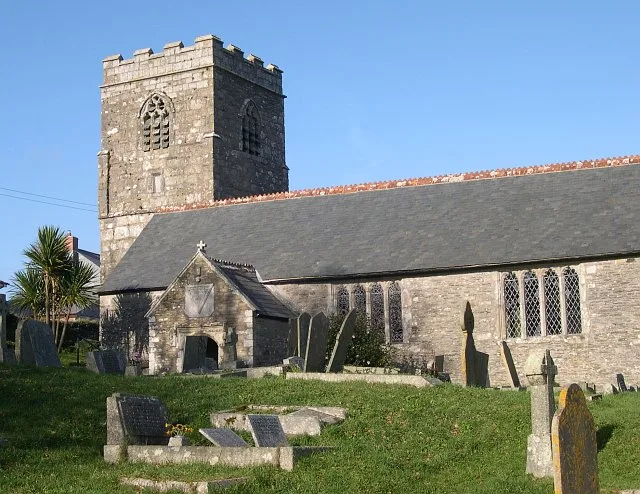
St Veep
In or near Polruan.
St Veep (Cornish: Sen Vip) is a civil parish in Cornwall, England, United Kingdom, situated above the east bank of the River Fowey about three miles (5 km) south-east of Lostwithiel. It is bordered by

Rob Farrow — CC BY-SA 2.0 via Wikimedia Commons licence
Plan your visit
- Typical visit
- 30 min–1 h
- Nearest railway station
- Lostwithiel · 5.8 km
- Free entry
About
St Veep (Cornish: Sen Vip) is a civil parish in Cornwall, England, United Kingdom, situated above the east bank of the River Fowey about three miles (5 km) south-east of Lostwithiel. It is bordered by the parishes of St Winnow to the north-west, Boconnoc to the north, Lanreath to the east Polperro to the south-east and Lanteglos to the south. The River Fowey forms its western boundary. The parish is named after Saint Veep of whom little is known (not even whether the saint was male or female). Part of the village of Lerryn is in St Veep parish. The hamlets of Cliff (50.369°N 4.634°W / 50.369; -4.634 (Cliff)), Higher Penpol (50.360°N 4.616°W / 50.360; -4.616 (Higher Penpol)), Middle Penpol and Lower Penpol (50.360°N 4.607°W / 50.360; -4.607 (Lower Penpol)) are all within the parish.
Photo gallery
Protected designations
- Area of Outstanding Natural Beauty: Cornwall
Designations sourced from Natural England open data under OGL v3.
From the Wikipedia article
St Veep (Cornish: Sen Vip) is a civil parish in Cornwall, England, United Kingdom, situated above the east bank of the River Fowey about three miles (5 km) south-east of Lostwithiel. It is bordered by the parishes of St Winnow to the north-west, Boconnoc to the north, Lanreath to the east Polperro to the south-east and Lanteglos to the south. The River Fowey forms its western boundary. The parish is named after Saint Veep of whom little is known (not even whether the saint was male or female). Part of the village of Lerryn is in St Veep parish. The hamlets of Cliff (50.369°N 4.634°W / 50.369; -4.634 (Cliff)), Higher Penpol (50.360°N 4.616°W / 50.360; -4.616 (Higher Penpol)), Middle Penpol and Lower Penpol (50.360°N 4.607°W / 50.360; -4.607 (Lower Penpol)) are all within the parish.
Excerpt from Wikipedia under CC BY-SA 4.0. See the source article linked in Sources below.
Background
History
The parish church was originally dedicated to Saint Veep, but when it was rebuilt in 1336 it was rededicated to Saint Quiricus and Saint Julietta. Following the Prayer Book Rebellion of 1549, a number of well-known Cornish figures and priests were murdered or hanged in Cornwall. These included Richard Bennet, vicar of St Veep, under the direct orders of Anthony Kingston, Provost Marshal serving under King Edward VI. Valuable church silverware, which had been deposited with Lloyds Bank of St Austell and subsequently lost, was rediscovered in 2015 at a storage facility near Glasgow. Items included a communion cup (dated 1579), silver flagon tankard (1737) and a silver plate (1738).
Sourced from Wikipedia under CC BY-SA 4.0.
- Coordinates
- 50.3650, -4.6180
- District
- Cornwall
- Parish
- St. Veep
- Postcode
- PL22 0PA
- Parliamentary constituency
- South East Cornwall
- Nearest railway station
- Lostwithiel — 5.8 km
Sources
- wikipedia: St Veep (CC BY-SA 4.0)
Other places nearby
St Cyricius and St Julietta's Church
Historic churches · 0.1 km

Saint Veep
Villages · 0.2 km

St Cadix's Priory
Abbeys & priories · 0.6 km

Penpol Mill
Watermills · 0.9 km

River Lerryn
Museums · 1.6 km

Golant
Historic churches · 1.7 km
St Sampson's Church
Historic churches · 1.9 km

Lanteglos
Villages · 2.0 km

Ethy rock
Historic houses · 2.0 km

Lerryn
Villages · 2.2 km

Golant YHA
Hostels · 2.2 km

Lanteglos-by-Fowey
Historic churches · 2.2 km
Nearby
📷 4Historic churches · South West England
St Cyricius and St Julietta's Church
St Cyricius and St Julietta's Church — Grade I listed building-listed church in england-south-west, United Kingdom.
📷 5📷 3Abbeys & priories · South West England
St Cadix's Priory
St Cadix's Priory — a abbey in england-south-west, United Kingdom.
📷 5📷 4Museums · South West England
River Lerryn
River Lerryn — a museum in england-south-west, United Kingdom.
📷 5Historic churches · South West England
Golant
Golant (Cornish: Golnans) is a village in south Cornwall, England, United Kingdom. It is on the west bank of the River Fowey and in the civil parish of St Sampson. Golant is about two miles (3.2 km) n
Where to eat & stay near St Veep
Places to stay
📷 4 📷 5
📷 5Campsites · South West England
Penmarlam Caravan and Camping Park
Penmarlam Caravan and Camping Park — a campsite in england south west.
 📷 5
📷 5Campsites · South West England
Tremeer Farm
Tremeer Farm — a campsite in england south west.
 📷 5
📷 5Hotels · South West England
The Old Quay House Hotel
The Old Quay House Hotel — a hotel in england south west.
 📷 5
📷 5Campsites · South West England
Chuchtown Farm Campsite
Chuchtown Farm Campsite — a campsite in england south west.
 📷 5
📷 5Hotels · South West England
King of Prussia
King of Prussia — a hotel in england south west.
Places to eat & drink
 📷 7
📷 7Historic pubs · South West England
The Pack Horse Public House
The Pack Horse Public House in England South West, United Kingdom.
 📷 7
📷 7Restaurants · South West England
The House on the Props
The House on the Props — a restaurant in england south west.
 📷 7
📷 7 📷 5
📷 5 📷 5
📷 5Restaurants · South West England
Pier House Hotel
Pier House Hotel — a restaurant in england south west.
 📷 5
📷 5Historic pubs · South West England
The Fisherman's Arms
The Fisherman's Arms in England South West, United Kingdom.
More places in this region
 📷 5
📷 5Historic churches · South West England
Abbey Church of St Gregory the Great, Downside Abbey
Abbey Church of St Gregory the Great, Downside Abbey — church in Stratton-on-the-Fosse, Somerset, England, UK.
 📷 5
📷 5Historic churches · South West England
All Saints Church
All Saints Church — Grade I listed church in Woolley, Somerset, England, UK.
 📷 5
📷 5Historic churches · South West England
All Saints Church, Hampreston
All Saints Church, Hampreston — church in Hampreston, Dorset, England, UK.
 📷 5
📷 5Historic churches · South West England
All Saints Church, Nether Cerne
All Saints Church, Nether Cerne — church in Nether Cerne, Dorset, England, UK.
Frequently asked questions
- Where is St Veep?
- St Veep is in South-West England, United Kingdom (postcode PL22 0PA), in the parish of St. Veep.
- What is St Veep?
- St Veep (Cornish: Sen Vip) is a civil parish in Cornwall, England, United Kingdom, situated above the east bank of the River Fowey about three miles (5 km) south-east of Lostwithiel. It is bordered by
- How do I get to St Veep?
- The nearest railway station is Lostwithiel, about 5.8 km away. Drivers can use postcode PL22 0PA.
- Is St Veep a protected site?
- Yes — St Veep is part of the Cornwall National Landscape (AONB).
- Is St Veep free to visit?
- Yes, St Veep is free to enter.
- How do I get to St Veep?
- The nearest railway station is Lostwithiel, about 5.8 km away. Drivers can navigate to postcode PL22 0PA.